
Calgary Split by a Temperature Wall: Pacific Warmth vs Arctic Air Could Deliver 10°C Swings Across Alberta City Today
CALGARY, ALBERTA — A sharp and dramatic temperature divide is setting up across Calgary today as Pacific air collides head-on with entrenched Arctic cold, creating what meteorologists describe as one of the trickiest high-temperature forecasts of the winter.
High-resolution model guidance shows a narrow but intense boundary slicing through the region, with some neighborhoods potentially climbing into the +8°C to +10°C range, while others remain stuck below freezing — or even well below zero.
A City Divided: Arctic North, Pacific South
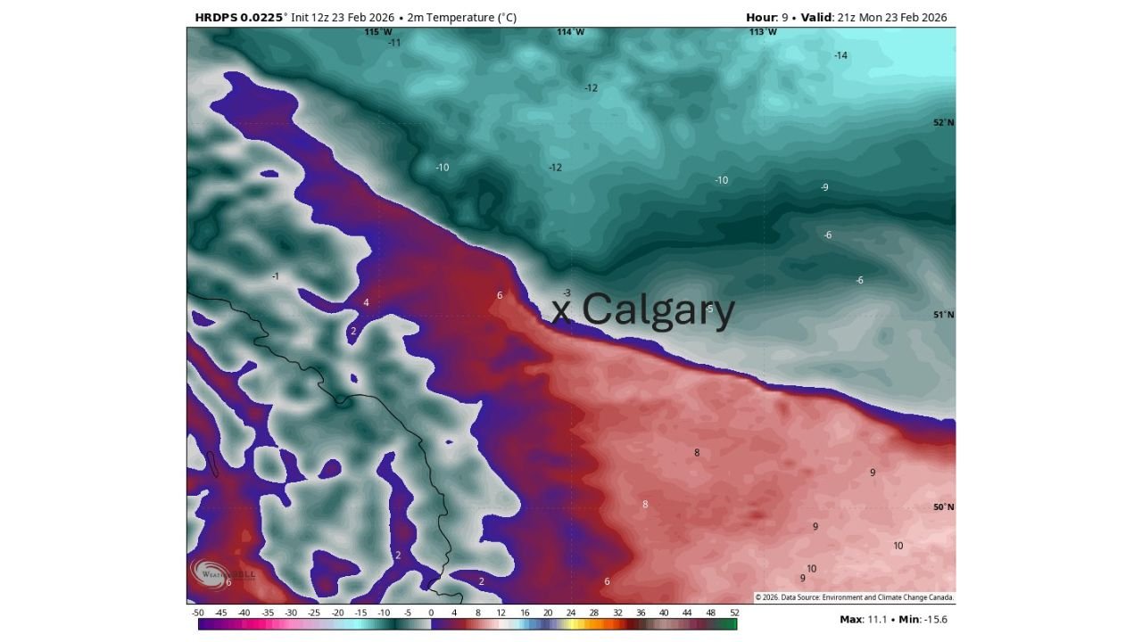
Latest HRDPS temperature projections valid Monday afternoon show:
- -10°C to -14°C north and northeast of Calgary
- Around -6°C to -9°C in northern suburbs
- Near -3°C to +2°C across parts of central Calgary
- +6°C to +10°C just south and southeast of the city
This sets up a striking gradient over a relatively short distance — a classic battleground between Pacific-modified air pushing in from the southwest and Arctic air holding firm over southern Alberta.
Why the Forecast Is So Tricky
The sharp dividing line between cold and mild air is extremely narrow, meaning:
- A slight shift in wind direction could dramatically alter temperatures.
- Chinook winds could surge farther north than expected.
- Arctic air could hold stronger than models anticipate.
In setups like this, one suburb could see melting snow and mild breezes, while another experiences biting cold just a few kilometers away.
These types of temperature contrasts are common near the foothills of the Canadian Rockies, where elevation changes and wind patterns amplify differences.
Potential Temperature Spread: Nearly 20°C Difference Nearby
Model data suggests a possible 15°C to 20°C temperature difference between northern Alberta plains and areas just south of Calgary.
Even within city limits, swings of 8°C to 12°C between communities are possible depending on how far the warmer Pacific air advances.
If the warmer air fully mixes into the metro area, highs could approach the upper single digits Celsius in some districts. If the Arctic air remains entrenched, some neighborhoods may struggle to climb above freezing.
Pacific vs Arctic: The Atmospheric Battle
The current setup shows:
- Pacific air streaming inland from British Columbia
- Arctic high pressure anchored over central and northern Alberta
- A sharp frontal boundary marking the collision zone near Calgary
This creates a narrow zone of temperature contrast — almost like a “temperature wall” — directly across the city.
These contrasts are especially common in late winter when seasonal transitions increase variability.
What Residents Should Expect
Because the dividing line is so tight, Calgary residents could notice:
- Rapid temperature shifts during the day
- Strong localized wind changes
- Uneven snowmelt patterns
- Very different road conditions across short distances
Drivers traveling from north to south Calgary may experience noticeably different surface conditions within minutes.
A Classic Calgary Weather Wildcard
Calgary is no stranger to dramatic winter temperature swings, particularly when Chinook winds interact with Arctic air masses. However, the tightness of today’s gradient makes it especially difficult to pinpoint exact high temperatures citywide.
Meteorologists caution that official high readings may vary significantly depending on which side of the boundary dominates by peak heating this afternoon.
WaldronNews.com will continue monitoring how this Pacific–Arctic temperature clash unfolds across Calgary and southern Alberta today.