
California Braces for Major Cold Storm Through February 19 as Sierra Nevada Faces Feet of Snow and Heavy Rain Threatens San Francisco and Los Angeles — Another System Expected February 23–25
UNITED STATES — A powerful cold storm is lining up to drench California with heavy rain along the coast and dump multiple feet of snow across the Sierra Nevada through February 19, according to multiple global forecast models. Meteorologists are also tracking another storm system expected to impact the state between February 23 and February 25.
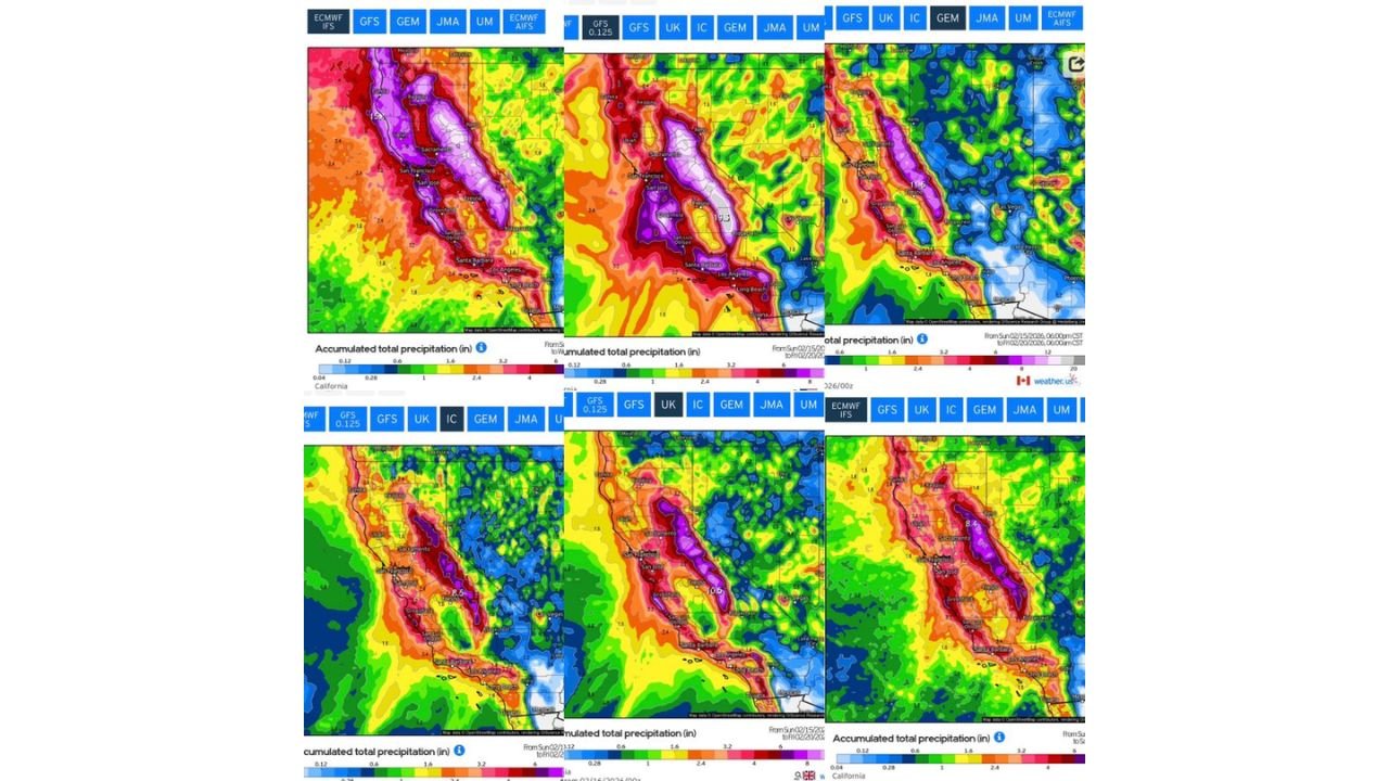
Forecast model consensus — including ECMWF, GFS, GEM, UKMET, and JMA — shows widespread precipitation totals stacking up across Northern, Central, and Southern California, with the heaviest amounts focused along the Sierra Nevada mountain range and coastal ranges.
Sierra Nevada Could See Feet of Snow Through February 19
Model guidance consistently highlights extreme precipitation totals across the Sierra Nevada, stretching from near Redding and Lake Tahoe southward past Yosemite and into the higher elevations above Fresno and Bakersfield.
Color-scale projections show:
- 8 to 12+ inches of liquid equivalent precipitation in the higher elevations
- Snowfall totals potentially measuring in feet, especially above 5,000–6,000 feet
- Low snow levels due to the cold nature of the system
Communities near Sacramento, Lake Tahoe, Fresno, and the Central Sierra are positioned near the core of the heaviest precipitation zone. Mountain travel could become extremely difficult with heavy snow rates and potential chain controls.
The cold structure of the storm suggests snow levels will drop lower than typical atmospheric river events, increasing the chance for accumulating snow at mid-elevations.
Heavy Rain Targets San Francisco, Sacramento, and Central Valley
Widespread rainfall is projected across Northern California, including:
- San Francisco Bay Area
- Sacramento Valley
- San Jose and surrounding communities
Accumulated precipitation totals across lower elevations appear in the 2 to 5 inch range, with locally higher amounts in foothill and coastal terrain.
Urban flooding, ponding on roads, and rapid rises on creeks and streams are possible if the heaviest rain bands materialize.
Southern California Also in the Impact Zone
Forecast panels show significant precipitation extending into Southern California, including:
- Los Angeles
- Santa Barbara
- Long Beach
- Inland valleys and coastal mountain slopes
While totals are generally lower than the Sierra maxima, several inches of rain are still possible in favored upslope areas.
Burn scar locations will need monitoring for localized debris flow risks if intense rain rates develop.
Strong Model Agreement Increases Confidence
Multiple international forecast models — including ECMWF, GFS, UKMET, GEM, and JMA — show similar placement of the heavy precipitation axis across California. This agreement increases confidence that:
- The Sierra Nevada will see significant snowfall accumulation
- Coastal and valley regions will experience widespread heavy rainfall
- Impacts will last through at least February 19
The broad area of red and purple shading across nearly all model outputs underscores the high-impact nature of this event.
Another Storm Expected February 23–25
Longer-range guidance signals a second storm system arriving around February 23 through February 25, potentially renewing rainfall and snowfall across the same areas.
If the first system saturates soils and builds a deep mountain snowpack, the follow-up storm could compound impacts, particularly in flood-prone and mountain travel corridors.
What This Means for Residents
Residents across California should prepare for:
- Hazardous mountain travel
- Possible chain controls or road closures in the Sierra
- Urban and small stream flooding
- Delays due to heavy rain and snow
Those in higher elevations should monitor snowfall forecasts closely, while coastal and valley residents should stay alert for flood advisories or warnings.
The coming days represent a classic cold Pacific storm setup for California — one capable of delivering both beneficial water supply gains and disruptive weather impacts.
WaldronNews.com will continue monitoring updates as the February 19 system unfolds and as the next storm approaches February 23–25.