
California Central Valley Faces Rare Severe Weather Risk With Damaging Winds and Tornado Potential on Wednesday
CALIFORNIA — Parts of California’s Central Valley are facing an unusually rare severe weather setup on Wednesday, December 24, as a strong Pacific storm system brings the potential for damaging winds, flooding rainfall, hail, and even a low-end tornado threat to a region that seldom experiences such hazards.
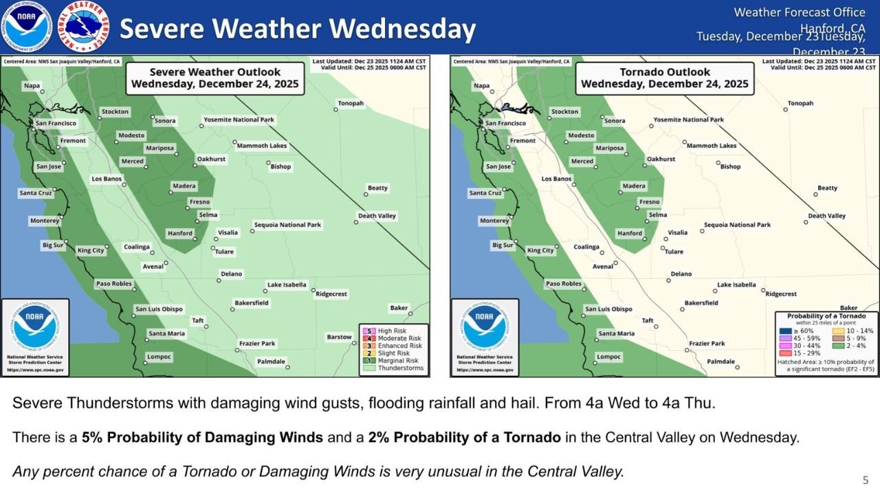
According to forecast outlooks from the National Weather Service Weather Prediction Center and the Hanford Weather Forecast Office, a broad swath of the Central Valley has been placed under a Marginal Risk for severe thunderstorms through early Thursday morning, with impacts expected from 4 a.m. Wednesday through 4 a.m. Thursday.
Meteorologists emphasize that any severe weather signal at all is highly unusual for this region, especially during late December.
Damaging Wind Gusts Highlight Primary Threat Across the Central Valley
Forecast guidance indicates a 5% probability of damaging wind gusts across portions of the San Joaquin Valley, including areas near Fresno, Madera, Merced, Hanford, and Visalia.
While a 5% probability may sound low compared to Midwest or Southern Plains standards, forecasters stress that this level of risk is significant for California’s interior valleys, where severe thunderstorms are infrequent.
Strong downdrafts associated with fast-moving storms could produce localized wind damage, downed tree limbs, and isolated power outages, particularly in open agricultural areas.
Low-End Tornado Risk Adds to Unusual Setup
In addition to wind threats, outlook maps show a 2% probability of a tornado within the Central Valley on Wednesday.
Any tornado risk in this region is considered exceptional, as the area typically lacks the instability and wind shear needed for rotating storms. However, this system is expected to feature strong upper-level dynamics and enhanced wind profiles, creating a narrow window where brief tornado spin-ups could occur.
Forecasters note that even weak tornadoes in California can cause damage, especially in rural or lightly built areas.
Flooding Rainfall and Small Hail Also Possible
Beyond wind and tornado concerns, storms moving through the region may produce periods of heavy rainfall, raising the risk of localized flooding, particularly in low-lying or poor-drainage locations.
Small hail is also possible within stronger storm cells, though it is expected to be a secondary threat compared to wind.
Why This Event Is So Unusual for the Central Valley
Meteorologists stress that any measurable chance of severe thunderstorms in the Central Valley is rare, especially during winter.
The current setup combines:
- A strong Pacific storm system
- Enhanced atmospheric instability
- Unseasonably strong wind energy aloft
This combination is not typical for California, making Wednesday’s forecast noteworthy even if impacts remain isolated.
Residents are urged to stay weather-aware, monitor official updates, and be prepared for rapidly changing conditions.
What Residents Should Do
Officials recommend that Central Valley residents:
- Secure loose outdoor items
- Monitor local weather alerts
- Avoid flooded roadways
- Have a plan in place in case warnings are issued
Even brief severe storms can create hazardous travel and outdoor conditions.
Severe weather may be uncommon in California’s Central Valley, but Wednesday’s forecast shows that it is not impossible. Staying informed could make all the difference as this rare event unfolds.
For continued weather updates and regional coverage, stay with WaldronNews.com.