
California Faces High-Impact Pacific Storm With Flooding Rain, Damaging Winds, and Burn Scar Risks Through Christmas Week
CALIFORNIA — On Friday, December 19, 2025, at 9:49 a.m., meteorologists confirmed that a powerful Pacific storm system originating near the Marshall Islands is expected to impact large portions of California, bringing the threat of heavy rainfall, flooding, and damaging winds statewide as the system intensifies heading into Christmas week.
Forecasters warn that this storm is strengthening as it moves east across the Pacific and could become one of the most impactful weather events California has seen in years, particularly because of its timing, moisture content, and wind potential.
Storm Timing and Expected Impacts
According to forecast data, conditions will deteriorate rapidly beginning early next week, with impacts increasing from December 23 through December 25.
Key expected impacts include:
- Heavy rainfall capable of producing flooding
- Wind speeds of 60 to 80 mph, especially in coastal and mountain areas
- Downed trees and power lines
- Widespread power outages
- Dangerous travel conditions
Meteorologists note that storms delayed for long periods over the Pacific often arrive stronger than originally projected, and this system fits that pattern.
Rare Storm Pattern Raises Historical Concerns
Weather experts say the evolving setup resembles December 2004, when unusually warm Pacific waters fueled powerful storms across California. In that event, extreme warmth preceded significant rainfall and wind damage, similar to what is now being observed with this system.
The warming of Pacific waters has played a key role in allowing the storm to retain strength and moisture, increasing confidence in high-impact outcomes.
Burn Scar Zones Face Elevated Flood and Mudslide Risk
Areas affected by previous wildfires are at particularly high risk during this storm.
Residents in and near:
- Eaton Fire Burn Scar Zone
- Pacific Palisades Burn Scar Zone
are urged to prepare for rapid runoff, debris flows, and possible mudslides, even if rainfall occurs over a short period.
Emergency officials recommend:
- Having sandbags ready
- Clearing drainage paths
- Remaining alert for evacuation warnings
- Avoiding canyon roads during heavy rain
Bay Area and Southern California Wind Threats
The San Francisco Bay Area is expected to experience strong winds capable of snapping tree limbs and toppling weakened trees, with impacts potentially beginning as early as December 23.
Meanwhile, Santa Barbara County through western Los Angeles County faces an increased risk of:
- Power outages
- Fallen trees
- Infrastructure damage
Wind gusts in these regions could range from 45 to 80 mph, depending on local terrain and storm evolution.
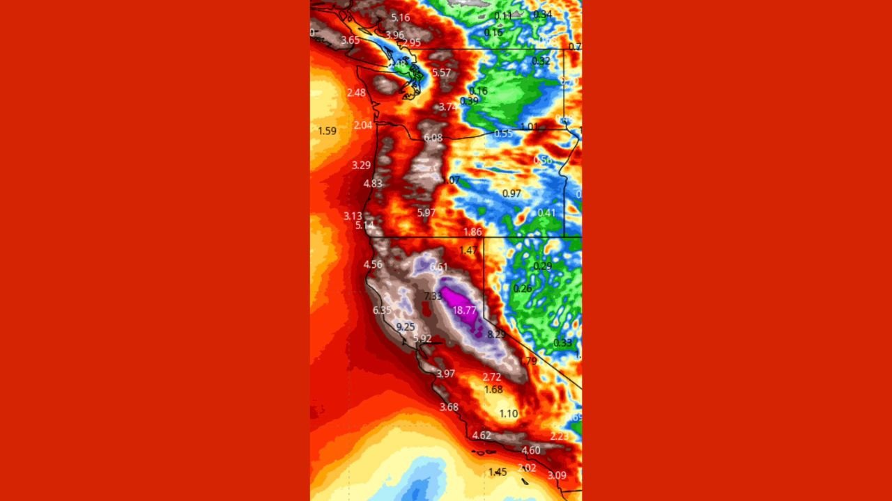
Rainfall Totals and Flooding Concerns
Forecast rainfall maps indicate:
- Several inches of rain across much of California
- Higher totals along coastal ranges and foothills
- Lower but still impactful totals inland
With soils already vulnerable in many areas, forecasters warn that flash flooding is possible, especially during periods of intense rainfall.
Snow Levels Remain High in the Mountains
Despite the storm’s strength, snow levels are expected to stay above 7,000 feet, meaning:
- Most mountain resorts may receive rain or only light snow
- Significant snowfall likely limited to elevations above 8,000 feet
Colder air may arrive after December 26 or 27, potentially lowering snow levels with a secondary system.
Next 24 to 48 Hours Considered Critical
Meteorologists emphasize that the next 24 to 42 hours will be crucial as forecast confidence continues to increase.
Residents across California are urged to:
- Monitor official forecasts closely
- Prepare for possible power outages
- Secure outdoor items
- Avoid unnecessary travel during peak storm periods
Forecasters stress that this storm highlights the power of Pacific-driven weather systems and their ability to produce rapidly escalating impacts across California, particularly during the holiday season.