
California Faces Moderate Risk of Excessive Rainfall as Day 3 Outlook Highlights Flood Potential Along the Coast and Interior
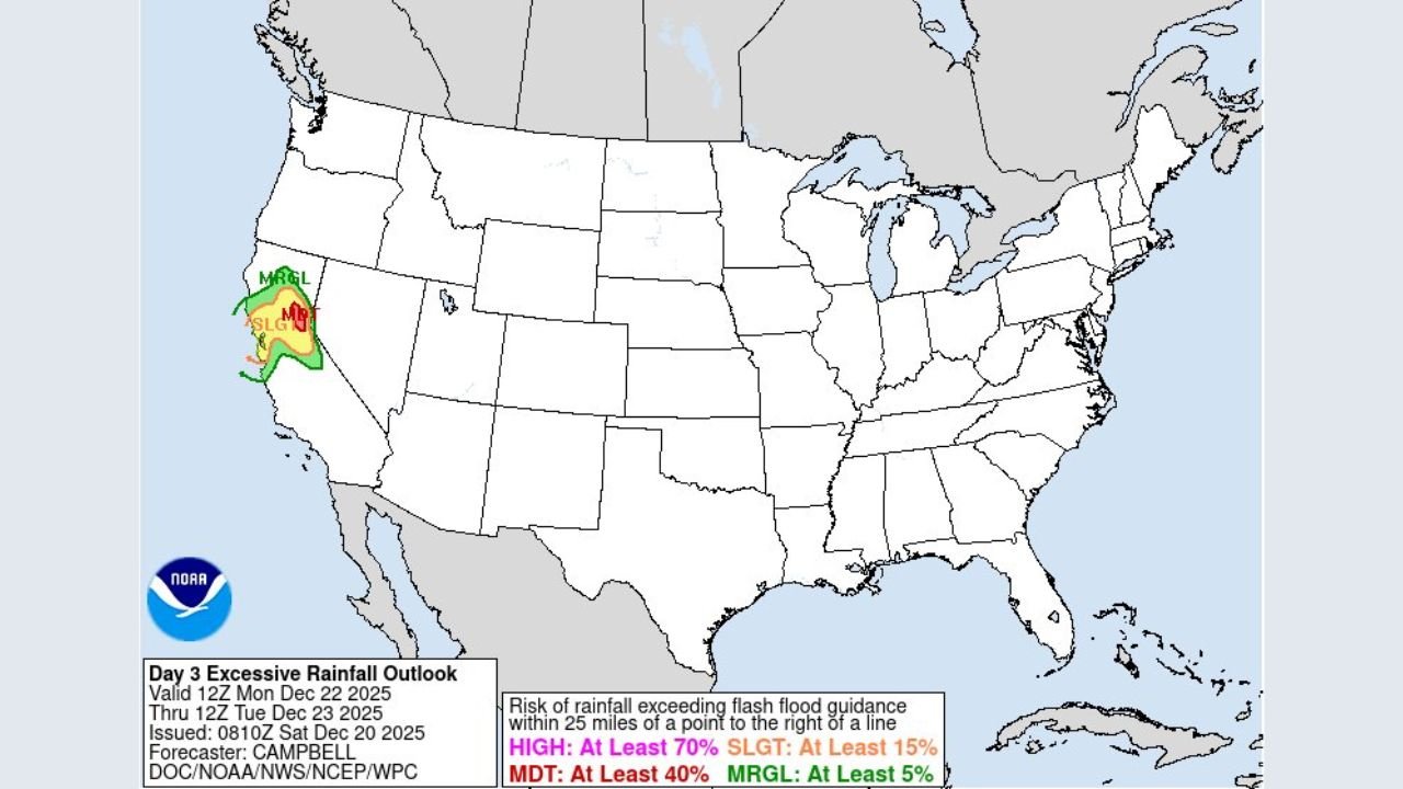
CALIFORNIA — The National Weather Service’s Weather Prediction Center has issued a Day 3 Excessive Rainfall Outlook showing a Moderate Risk of flooding across parts of California, signaling a heightened threat for flash flooding, urban flooding, and rapid runoff beginning Monday, December 22, and continuing into early Tuesday, December 23.
According to the outlook, portions of central and northern California are most at risk, where repeated rounds of rain could overwhelm creeks, rivers, and drainage systems.
What the Day 3 Excessive Rainfall Outlook Means
The Moderate Risk category indicates a significant chance of rainfall exceeding flash flood guidance, particularly within 25 miles of highlighted areas. In these zones:
- Flash flooding is possible
- Low-lying roads and underpasses may flood
- Rapid rises on small streams and creeks are likely
- Mudslides and debris flows are a concern, especially near burn scars
The Weather Prediction Center classifies risk levels as Marginal, Slight, Moderate, and High, with Moderate Risk representing a serious flooding concern that can impact communities.
Areas Most Impacted in California
Based on the latest map data, the highest rainfall and flood risk is concentrated across:
- Coastal and inland sections of Northern California
- Parts of Central California, including interior valleys and foothills
- Areas where terrain and recent rainfall increase runoff potential
The outlook also highlights surrounding Slight Risk zones, meaning heavy rain impacts could expand depending on how storm bands evolve.
Why Flooding Is a Concern
Meteorologists point to persistent rain bands moving over the same areas, increasing the likelihood of:
- Saturated soils
- Runoff exceeding drainage capacity
- Localized flash flooding, even outside of major rivers
When rainfall rates outpace absorption, flooding can occur quickly — sometimes within minutes — especially in urban areas and near hillsides.
Timing of the Threat
- Rainfall risk increases late Monday
- Heaviest impacts expected overnight into early Tuesday
- Flooding may persist even after rain tapers off due to runoff
Safety Guidance for Residents
Officials urge residents in affected parts of California to remain alert and take precautions:
- Avoid driving across flooded roads
- Be prepared for road closures or travel delays
- Monitor local weather alerts and emergency updates
- Have a plan in place if flooding develops rapidly
Even areas outside the core Moderate Risk zone could see localized flooding if heavier rain bands shift.
What Happens Next
Forecast confidence will continue to improve as the event approaches. Any increase in rainfall intensity or expansion of the Moderate Risk area could elevate flooding impacts.
Residents across California’s coastal and interior regions should stay weather-aware and be prepared to act if flood warnings are issued.
For continuing coverage and weather updates, stay connected with WaldronNews.com.