
California Faces Strong Christmas Holiday Storm as Southern California Braces for Flooding, Heavy Rain, and Gusty Winds
CALIFORNIA — A strong and potentially high-impact storm system is set to affect Southern California during the Christmas holiday period, bringing several days of rain, elevated flood risks, and gusty winds across the region. Forecast data and National Weather Service outlooks indicate the most dangerous conditions are likely Tuesday night through Wednesday, with impacts extending into the latter half of the week.
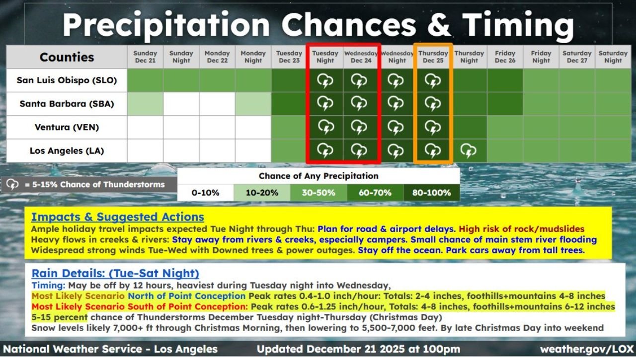
Forecasters warn that the timing of this system — coinciding with holiday travel and outdoor plans — could significantly amplify disruptions across Los Angeles, Ventura, Santa Barbara, and San Luis Obispo counties.
“This is not a one-day event — the prolonged nature of the rainfall raises flooding and debris-flow concerns, especially in urban areas and recent burn scars.”
Rain Expected Tuesday Through Saturday Across Southern California
Forecast guidance shows rain developing Tuesday, increasing in coverage and intensity through Wednesday, then continuing at varying levels into Friday and Saturday.
- Heaviest rainfall: Tuesday night through Wednesday
- Rain duration: Tuesday through Saturday
- Thunderstorms: Isolated chances Tuesday night through Thursday
Rainfall rates during peak periods could overwhelm drainage systems, especially in low-lying and urban areas.
Flood Watch Issued for All Four Counties
A Flood Watch is in effect from Tuesday afternoon through Wednesday evening for:
- Los Angeles County
- Ventura County
- Santa Barbara County
- San Luis Obispo County
Officials warn that urban flooding, roadway ponding, and debris flows are possible — particularly near foothills, canyons, and wildfire burn scars.
“Debris flows and rapid runoff remain a serious concern where soils cannot absorb additional rainfall.”
Forecast Rainfall Totals Raise Flood Concerns
Storm-total rainfall projections show significant accumulation across the region, with higher totals in foothill and mountain zones.
Estimated Storm Totals (Tuesday–Saturday):
- Coastal and valley areas: 4–8 inches
- Foothills and mountains: 8–12 inches
- Localized higher amounts possible near terrain-favored areas
Some locations in the Transverse Ranges and Santa Ynez Mountains may see double-digit rainfall totals, increasing the risk of mudslides and road closures.
Gusty Southeast Winds Add to Impact Potential
In addition to heavy rain, gusty southeast winds are expected Tuesday into Wednesday, which may:
- Down trees and power lines
- Cause scattered power outages
- Worsen travel conditions during peak rainfall
Combined wind and saturated soils heighten the risk of falling trees, especially in older neighborhoods.
Holiday Travel and Safety Impacts
The National Weather Service advises residents and travelers to prepare for:
- Road and airport delays
- Hazardous driving conditions
- Temporary closures near creeks, rivers, and coastal zones
- Dangerous ocean conditions — residents are urged to stay out of the water
“This is a storm where timing and preparedness will make a major difference.”
What Residents Should Do Now
- Avoid travel during peak rainfall windows
- Stay away from creeks, rivers, and burn-scar areas
- Secure outdoor objects before winds increase
- Monitor official updates as rainfall forecasts evolve
Bottom Line
A multi-day Christmas holiday storm is poised to impact Southern California, with heavy rain, flooding risks, and gusty winds expected from Tuesday through Saturday. The most dangerous conditions are likely Tuesday night into Wednesday, making this a storm that warrants close attention and preparation.
Stay with WaldronNews.com for continuous updates, localized impact reports, and safety guidance as this Southern California storm unfolds.