
California Flash Flood Emergency Hits Shasta County as Stationary Storm Dumps 3–6 Inches of Rain on Redding Area
REDDING, CALIFORNIA — A life-threatening flash flooding emergency is unfolding across Shasta County after multiple bands of heavy rain became nearly stationary over the Redding area, overwhelming roadways, neighborhoods, and drainage systems within just a few hours.
Local law enforcement and emergency officials confirmed that flash flooding remains ongoing, with several inches of rain already fallen and additional heavy rain continuing to redevelop over the same locations. Authorities described conditions as rapidly deteriorating, especially in downtown Redding and along major transportation corridors.
“This is a dangerous and life-threatening situation,” officials warned as floodwaters continued to rise.
Stationary Storm System Triggers Extreme Rainfall Rates
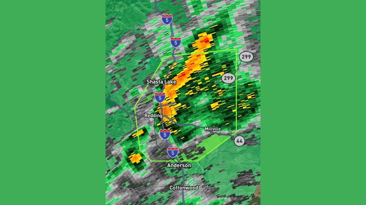
Radar imagery shows an intense, narrow rain band aligned north-to-south along the Interstate 5 corridor, stretching from near Shasta Lake through Redding and south toward Anderson and Cottonwood. The storm system has shown little movement, allowing repeated rounds of heavy rainfall to impact the same areas.
Meteorologists estimate between 3 and 6 inches of rain have already fallen across portions of the Redding metro area in a short time span — more than enough to trigger widespread flash flooding.
“The rain bands are not moving. They are redeveloping over the same locations.”
Flash Flooding Strands Vehicles and Forces Swift Water Rescues
Authorities confirmed that floodwaters quickly overtopped streets, underpasses, and low-lying roadways, leaving multiple vehicles stranded in rapidly moving water. Emergency crews were forced to conduct swift water rescues as drivers became trapped when roads flooded faster than expected.
Downtown Redding and adjacent urban corridors have been particularly hard hit, with runoff funneling into city streets and intersections. Officials stressed that even shallow-appearing water can conceal powerful currents.
“If you encounter water over the road, turn around immediately. Do not try to cross it.”
High-Risk Areas Include I-5 Corridor, Highway 299, and Nearby Communities
The most severe impacts have been reported along and east of Interstate 5, including areas near Highway 299 and toward Millville. Communities south of Redding, including Anderson and areas near Cottonwood, remain at elevated risk as runoff continues to move downstream.
With soils fully saturated, additional rainfall is producing immediate surface flooding rather than soaking into the ground, increasing the speed and severity of rising waters.
Emergency Warnings Remain in Effect as Flooding Continues
Emergency officials confirmed that flash flooding is still occurring, and conditions may worsen with little warning. Residents in flood-prone areas are urged to remain vigilant, especially as continued rainfall could cause sudden rises in creeks, drainage channels, and roadways.
Officials warned that nighttime conditions could further increase danger due to reduced visibility.
“Flooding can escalate rapidly, and conditions may become life-threatening with little notice.”
What Residents Should Do Right Now
Emergency management officials urge residents to take the following precautions immediately:
- Avoid all unnecessary travel
- Never drive through flooded roadways
- Move to higher ground if water levels rise
- Monitor local alerts and emergency instructions
Authorities continue to monitor rainfall totals, river responses, and urban flooding conditions across Shasta County as the storm remains locked in place.
Flash Flood Threat Remains Active Across Northern California
With heavy rain continuing and the storm system showing little movement, officials emphasize that the flash flooding threat is not over. Residents across Redding and surrounding communities should remain on high alert until conditions improve and waters recede.
“This is not a normal rain event. Lives are at risk.”
What are conditions like in your area? Have you experienced flooding, road closures, or power disruptions? Share your updates and stay informed with continuing coverage at WaldronNews.com.