
California Flash Flood Emergency Risk Escalates as ERO Issues Highest-Level Rainfall Outlook for Southern Counties
CALIFORNIA — A rapidly intensifying storm system is placing Southern California under one of the most serious flash flood threats seen this season, as federal forecasters elevate the region to the highest category for excessive rainfall and life-threatening flooding.
As of Monday afternoon, the Weather Prediction Center’s Excessive Rainfall Outlook (ERO) upgraded large portions of Santa Barbara County, Ventura County, Los Angeles County, and San Bernardino County into the “High Risk” category, signaling a significant danger for flash flooding, debris flows, and infrastructure impacts.
Why This Alert Is So Serious
The High Risk (purple) designation is rarely issued and is reserved for situations where widespread, dangerous flash flooding is expected, not just possible. Forecast guidance shows a prolonged, moisture-rich storm tapping into a strong atmospheric river — often referred to as a “Pineapple Express” — pushing directly into Southern California.
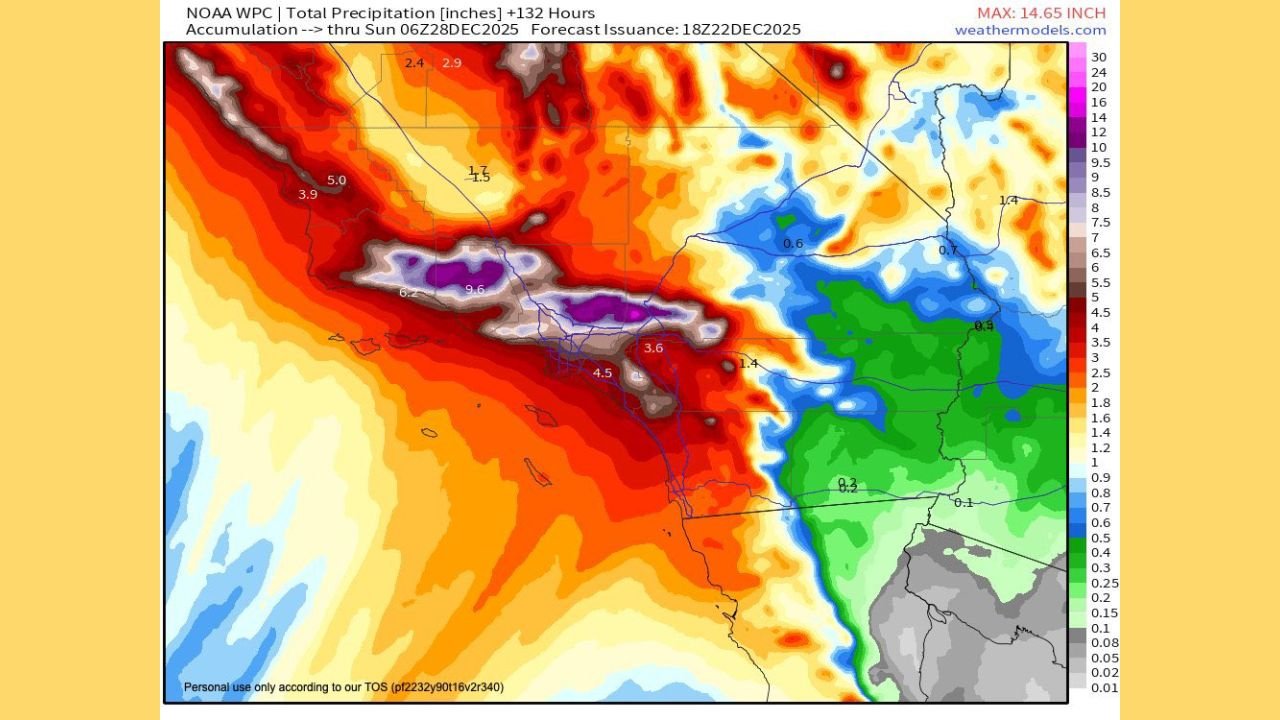
Rainfall totals through late week are projected to be extreme, particularly in foothills, burn-scar areas, and mountainous terrain.
Model guidance indicates:
- 4 to 8 inches of rain across coastal and valley areas
- 8 to 14+ inches in the Transverse Ranges and nearby mountains
- Intense rainfall rates capable of overwhelming drainage systems in a short time
Timing: When the Greatest Threat Occurs
The most dangerous window for flooding is expected to run from:
- Tuesday evening around 8 PM
- Through early Thursday morning around 4 AM
During this period, multiple rounds of heavy rainfall may repeatedly impact the same areas, dramatically increasing the risk for flash flooding and mudslides.
Counties and Cities at Highest Risk
Areas highlighted in the highest-risk zone include:
- Santa Barbara and Santa Maria areas
- Oxnard, Ventura, and surrounding coastal communities
- The Los Angeles Basin, including foothill neighborhoods
- Santa Clarita Valley
- Portions of San Bernardino County, especially near slopes and burn scars
Urban flooding is possible even outside of mountainous terrain due to the intensity of rainfall and saturated ground.
Flooding, Mudslides, and Burn Scar Concerns
Because Southern California terrain is steep and many regions were affected by recent wildfires, the threat is not limited to water alone. Debris flows, rockslides, and mudslides are a major concern, especially near canyon roads and hillside communities.
Emergency managers warn that flooding could occur rapidly and with little warning, even in locations that typically handle rainfall well.
What Residents Should Do Now
Officials urge residents to prepare immediately by:
- Avoiding travel during heavy rain periods
- Staying away from flood-prone roads and low-lying areas
- Having emergency alerts enabled on mobile devices
- Preparing for possible power outages and road closures
Conditions may deteriorate quickly once rainfall intensifies.
Forecast Confidence Remains High
Multiple forecast models and federal guidance agree on the overall setup, including the storm’s strength, moisture supply, and duration. While exact rainfall totals may still vary, confidence is high that dangerous flooding conditions will develop somewhere within the highlighted Southern California counties.
This is a rapidly evolving situation. Stay with WaldronNews.com for continued updates, localized impacts, safety guidance, and any new flood watches or warnings issued for California. If you live in an affected area, now is the time to prepare and stay informed.