
California, Oregon Face Heavy Rain and Mountain Snow Threat as Major Storm Pattern Returns Next Week
CALIFORNIA, OREGON — A significant shift in weather conditions is expected to take hold across the West Coast next week, with a widespread precipitation pattern forecast to bring cooler temperatures, heavy rainfall, and impactful mountain snow from Monday, March 30 through Friday, April 3.
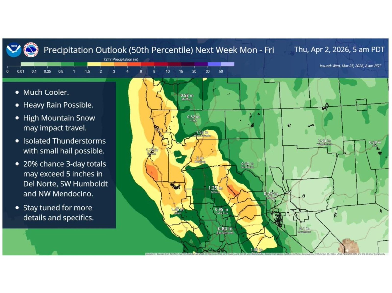
Forecast data indicates that much of California and parts of Oregon will be under a renewed storm system capable of delivering multiple days of steady precipitation. The setup suggests a classic Pacific-driven pattern, where moisture surges inland and interacts with mountainous terrain, increasing the risk of prolonged rainfall and travel disruptions.
Heavy Rain Bands Target Northern and Central California
The heaviest rainfall is expected across Northern and Central California, where forecast totals show widespread accumulation ranging from around 1 to 3 inches over several days. Some localized areas, particularly along the coastal ranges and foothills, could see even higher amounts.
A key concern highlighted in the outlook is a 20% chance that three-day rainfall totals could exceed 5 inches in specific regions including Del Norte County, southwestern Humboldt County, and northwestern Mendocino County. These areas are especially vulnerable due to terrain-enhanced rainfall and already moisture-prone landscapes.
Further inland, cities like Redding and Chico are projected to receive moderate rainfall totals, while areas like Sacramento and the northern San Joaquin Valley may also see steady, soaking rain.
Mountain Snow and Travel Concerns in Higher Elevations
In addition to rain, higher elevations across the Sierra Nevada and parts of southern Oregon are expected to receive significant snowfall. This could create hazardous travel conditions, especially along major mountain passes.
The combination of wet roads at lower elevations and snow-covered routes in the mountains could complicate travel across key corridors, particularly for those moving between inland valleys and coastal regions.
Cooler Temperatures Accompany the Storm System
Alongside the precipitation, temperatures across the region are expected to drop noticeably. The incoming system will usher in a much cooler air mass, reinforcing the stormy conditions and maintaining a prolonged period of unsettled weather.
This cooling trend will be felt across both coastal and inland areas, marking a sharp contrast from any recent mild or dry conditions.
Isolated Thunderstorms and Small Hail Possible
While the primary threat remains steady rainfall, the forecast also indicates the potential for isolated thunderstorms, particularly in parts of California. These storms could produce small hail and brief bursts of heavier rain, adding to localized impacts.
Although severe weather is not the main concern, these embedded storms could lead to sudden changes in conditions, especially during peak precipitation periods.
Broader Impact Extends Into the Interior West
Beyond California and Oregon, lighter precipitation is expected to spread into parts of Nevada, Idaho, Utah, and Arizona. However, totals in these regions are forecast to remain significantly lower compared to the West Coast.
Still, the widespread nature of this system highlights a broad-scale weather pattern affecting much of the western United States.
What to Expect Moving Forward
This developing storm pattern signals a return to active weather conditions across the West after any recent breaks in precipitation. With multiple days of rain, mountain snow, and cooler temperatures expected, residents and travelers should prepare for changing conditions throughout the week.
More detailed updates and refined forecasts are likely as the system approaches, particularly regarding rainfall intensity and snowfall totals in higher elevations.
Stay with Waldron News for the latest updates as this multi-day storm system begins to take shape across California and Oregon.