
California Sizzles in Late-Night Heat Wave: Malibu Hills Still 87°, San Francisco 72° at 9 PM — Winter Warmth Shatters Seasonal Norms Across Los Angeles, Mojave Desert and Central Coast
CALIFORNIA — An unusually intense burst of heat is gripping the Golden State tonight, with temperatures running far above seasonal averages — even well after sunset. In what is still technically winter, parts of Southern and Central California are experiencing conditions more typical of mid-summer.
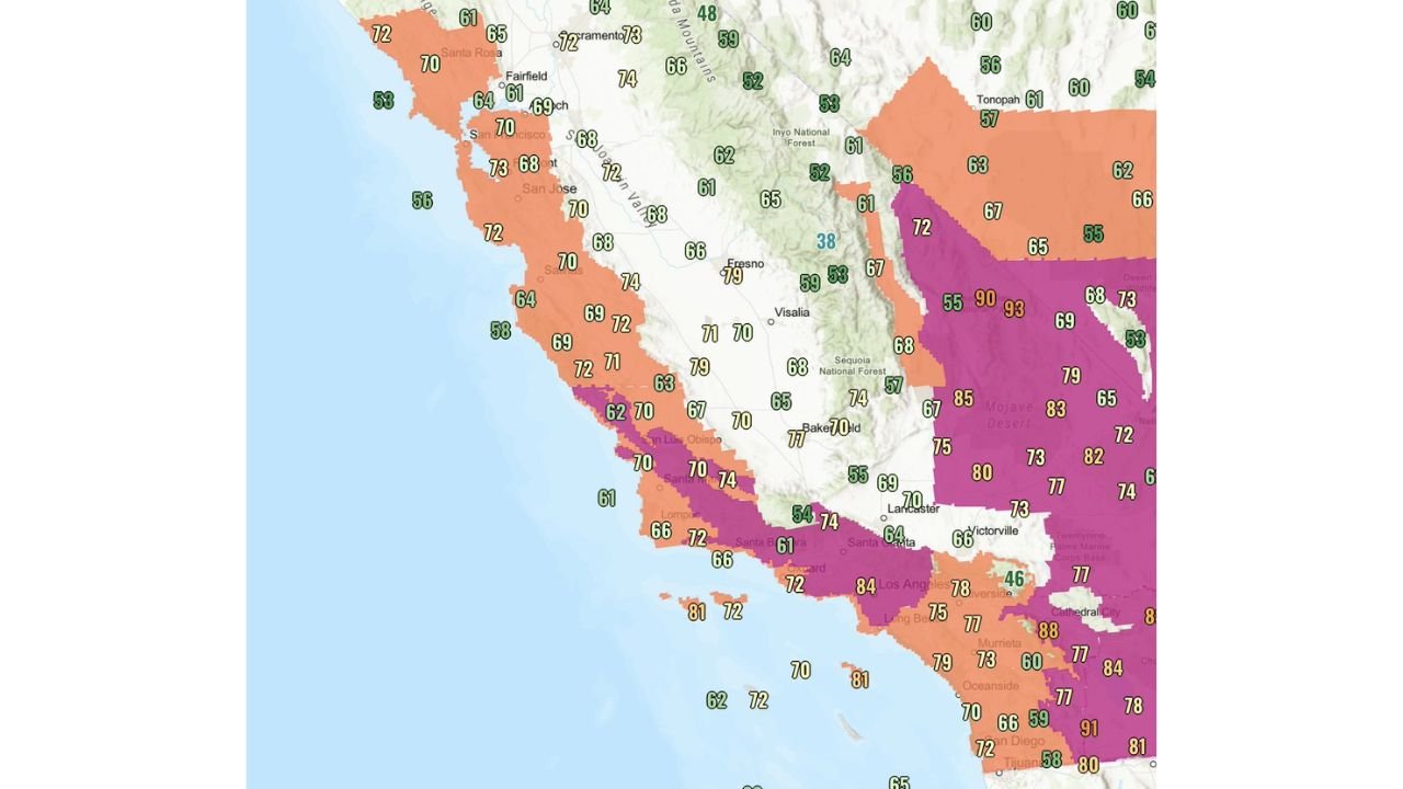
As of late evening observations, Malibu Hills remains at a staggering 87°F, while San Francisco International Airport (SFO) was still 72°F at 9 PM — nearly 10 degrees above its typical daytime high of 63°F for this time of year.
Temperatures Refuse to Drop After Dark
Across much of California, readings are holding in the 70s and 80s long after sunset. Coastal and inland areas alike are seeing abnormally warm nighttime conditions.
In the Bay Area:
- San Francisco: 70–73°F
- San Jose: around 70°F
- Santa Rosa: near 70°F
Along the Central Coast:
- San Luis Obispo: near 70°F
- Santa Barbara: low 70s
Southern California remains especially warm:
- Los Angeles: 84°F
- Long Beach: mid to upper 70s
- Riverside: upper 70s
- Malibu Hills: 87°F
Even offshore waters are reflecting elevated readings, with temperatures in the 70s near the Southern California coastline.
Desert Regions Running Hot
The Mojave Desert and inland desert valleys are showing some of the most extreme departures from seasonal norms.
- Portions of the Mojave Desert are reporting 85–93°F
- Cathedral City area: upper 80s
- Palm Desert region: near 90°F
For mid-March, these readings are significantly above average and more characteristic of late spring or early summer.
Central Valley Also Running Warm
While not as extreme as Southern California, parts of the Central Valley are still seeing elevated nighttime warmth.
- Fresno: upper 70s
- Bakersfield: mid to upper 70s
- Visalia: low 70s
Mountain areas, by contrast, remain cooler — largely in the 50s and 60s — highlighting the sharp thermal contrast across elevations.
Why Is It So Warm?
Such late-night warmth is typically associated with strong high-pressure ridging over the West Coast, allowing sinking air to compress and warm. Offshore flow patterns can also limit the typical marine cooling influence along coastal communities.
When these setups occur during winter, they can produce dramatic temperature anomalies — especially when skies remain clear and winds prevent rapid radiational cooling.
The most unusual factor tonight is not just the daytime heat, but how little temperatures have dropped after dark.
Still Technically Winter
Despite summer-like conditions, the calendar says otherwise. Meteorological winter does not end until late March, and average highs for much of coastal California this time of year range from the upper 50s to mid-60s.
For San Francisco to be sitting at 72°F at 9 PM — nearly matching or exceeding normal daytime highs — underscores just how anomalous this event is.
What Happens Next?
If high pressure remains entrenched, elevated temperatures could persist into the coming days, particularly across Southern California and interior valleys. However, any shift in wind direction or incoming trough could quickly knock temperatures back toward seasonal levels.
For now, Californians are experiencing an early preview of summer — with warm evenings, desert heat, and coastal communities refusing to cool down after sunset.
Stay with WaldronNews.com for continued updates on major weather developments across the United States.