
California, Washington, Montana, Texas and Florida Highlighted in XKCD Comic Breaking Down the Geology Behind America’s “Weird” Landscapes
UNITED STATES — A newly shared XKCD comic is getting attention for turning America’s complex geological history into a simple — and humorous — visual lesson, pointing out how forces like glaciers, volcanoes, rivers and plate tectonics shaped states including California, Washington, Montana, Texas and Florida.
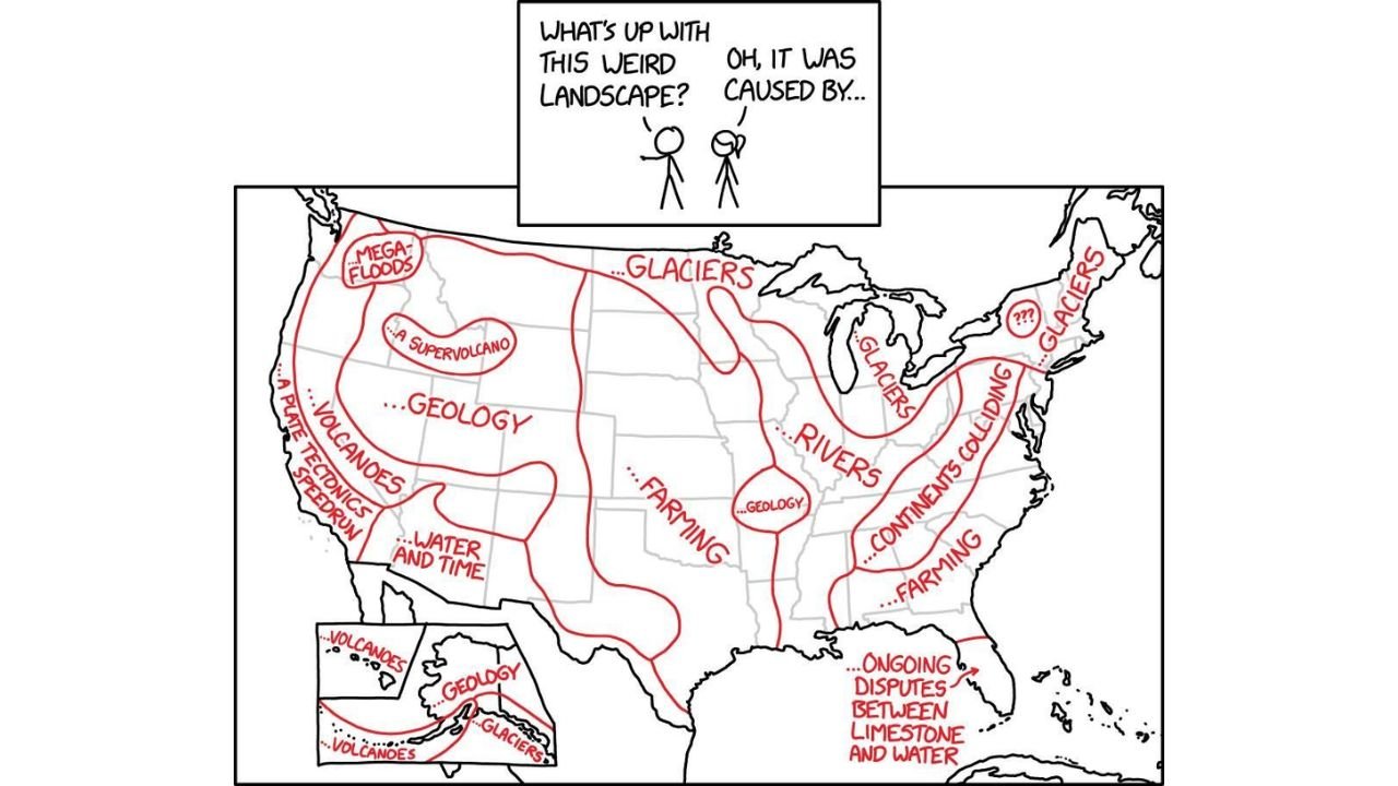
The comic opens with a simple question: “What’s up with this weird landscape?” The answer across the map? A wide array of powerful geological processes.
California and the West Coast: Plate Tectonics, Volcanoes and Mega-Floods
The West Coast, especially California, Oregon and Washington, is labeled with dramatic forces including:
- “A plate tectonics speedrun”
- “Volcanoes”
- “Mega-floods”
- “Water and time”
The comic highlights how the Pacific and North American plates interacting along California’s boundary have dramatically shaped its coastline and mountain ranges. Meanwhile, the Pacific Northwest is marked by ancient mega-flood events and ongoing volcanic influence.
Even a “supervolcano” is noted inland, nodding toward the geologic forces that shaped parts of the Intermountain West.
The Northern U.S.: Glaciers Carved the Landscape
Across Montana, North Dakota, Minnesota, Wisconsin and into the Northeast, one word dominates: “Glaciers.”
The comic emphasizes how massive ice sheets during the last Ice Age sculpted much of the northern United States, carving out the Great Lakes region and reshaping terrain from the Midwest to New England.
In states like Michigan and New York, glaciers are depicted as the primary driver behind the distinctive topography.
The Central Plains: Farming and Rivers
The Great Plains and Midwest are humorously summarized with labels like:
- “Farming”
- “Rivers”
- “Geology”
This reflects how ancient inland seas, sediment deposits and long-term river erosion shaped the relatively flat and agriculturally rich regions stretching through states such as Kansas, Nebraska, Iowa and Missouri.
The Mississippi River system is singled out as a defining landscape force for much of the central United States.
The East Coast: Colliding Continents
Along the Appalachian region — including Pennsylvania, Virginia and the Carolinas — the comic attributes the terrain to “continents colliding.”
This refers to ancient tectonic events that built the Appalachian Mountains hundreds of millions of years ago.
Farther south in Florida, the landscape is described as “ongoing disputes between limestone and water,” a nod to the state’s karst topography and sinkhole-prone geology.
Alaska and Hawaii: Volcanoes and Glaciers
Inset panels for Alaska and Hawaii point to:
- “Volcanoes”
- “Glaciers”
- Broad “Geology”
Hawaii’s volcanic origins are straightforward, while Alaska’s terrain reflects both glacial carving and tectonic activity.
A Humorous but Accurate Snapshot
Though lighthearted in tone, the comic captures real geological forces that shaped the United States over millions of years — from Ice Age glaciers in the north to tectonic collisions in the east and volcanic activity in the west.
For residents of states like California, Washington, Montana, Texas and Florida, the illustration offers a simplified explanation for why their landscapes look so different from one another.
Stay with WaldronNews.com for more science, weather and Earth-related stories from across the country.