
Carolinas Brace for Coldest Night of the Week as Arctic Air Drives Friday Morning Lows Into Teens and Single Digits
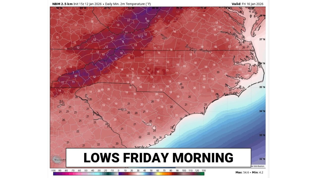
CAROLINAS — A surge of Arctic air settling over the Southeast is expected to deliver the coldest night of the week across North Carolina and South Carolina, with Friday morning shaping up as the chilliest start residents have felt in some time. Forecast data shows widespread teen-level temperatures, with even colder pockets in the foothills and mountains dipping toward single digits.
The cold will not be confined to inland areas. Even coastal communities, which typically avoid the worst of winter cold, are forecast to drop into the upper teens to low 20s by daybreak Friday.
How Cold It Gets and Where
Temperature guidance highlights a sharp north-to-south gradient across the region:
- Foothills and mountain communities:
Lows ranging from the upper single digits to low teens, especially in elevated valleys where cold air pools overnight. - Piedmont and central Carolinas:
Most locations falling into the mid to upper teens, marking one of the coldest mornings of the season so far. - Coastal plain and beaches:
Temperatures still dropping into the upper teens and low 20s, cold enough to surprise areas accustomed to milder winter nights.
This is a dry cold, but the lack of moisture does little to soften the bite, particularly just before sunrise.
Why This Cold Snap Stands Out
Unlike brief overnight cool-downs, this setup features:
- Clear skies, allowing heat to escape rapidly overnight
- Light winds at ground level, enhancing radiational cooling
- A fresh Arctic air mass, reinforcing the chill across the Southeast
These conditions are ideal for near-minimum temperature potential, meaning many locations may bottom out close to forecast lows.
Friday Morning Impacts
While no winter precipitation is expected, the cold could still cause issues:
- Frost and freeze risks for sensitive plants
- Icy patches in shaded or elevated spots where moisture lingers
- Vehicle starting issues, especially during the early commute
- Increased risk for vulnerable populations, including those without adequate heating
Anyone heading out early Friday should plan for heavy winter coats, gloves, and extra warm-up time for vehicles.
What Happens After Friday
Temperatures are expected to gradually moderate later Friday and into the weekend, but the early-morning cold will linger long enough to make Friday the coldest start of the week for much of the Carolinas.
Bottom Line
Friday morning will bring a sharp reminder of mid-winter cold to North Carolina and South Carolina, with teens common, single digits possible in higher elevations, and even coastal areas dipping near 20°F. While dry, this cold will be intense around daybreak and warrants preparation.
Stay with Waldron News for continued updates and regional temperature trends as this cold snap unfolds.