
Category 5 Atmospheric River to Slam Pacific Northwest Monday–Thursday, Bringing Flooding and Landslide Threats
Seattle, Washington — The Pacific Northwest is bracing for what meteorologists are calling the wettest storm system in several winters, as a Category 5 atmospheric river targets the region from Monday through Thursday. The prolonged event is expected to unleash torrential rainfall, river flooding, and landslides across parts of Washington, Oregon, and northern California.
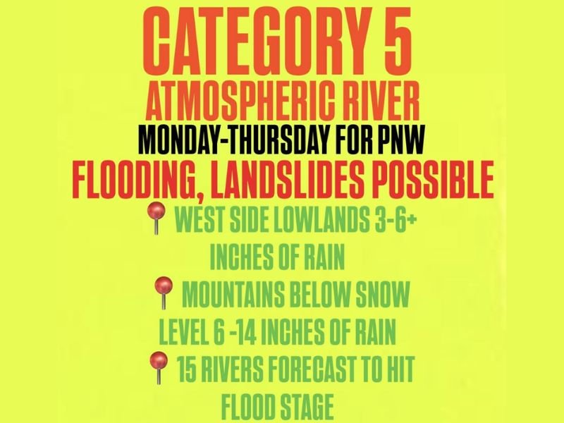
Atmospheric River to Bring Days of Intense Rain
An atmospheric river — a long, narrow corridor of deep tropical moisture — is forecast to stall over the Pacific Northwest coast early next week. According to early projections, lowland areas west of the Cascades could receive 3 to 6 inches of rain, while mountain regions below the snowline may see 6 to 14 inches.
Forecasters warn that this storm could rival or exceed some of the strongest systems of the past few years, with persistent onshore flow funneling warm, moisture-rich air from the Pacific Ocean.
“This is not just another rainstorm — this is a high-end atmospheric river,” one meteorologist noted. “It’s the kind of setup that can cause major flooding, rapid rises in rivers, and serious landslide hazards.”
Flooding and Landslides Expected
The National Weather Service is monitoring at least 15 major rivers that could reach or exceed flood stage during the event. Low-lying communities near the Chehalis, Skagit, and Willamette rivers are among those most at risk.
Continuous heavy rain over saturated ground will also raise the risk of landslides and debris flows, especially in western Washington and Oregon, where steep slopes are prone to instability after multiple wet days.
Residents in flood-prone or hillside areas are being urged to prepare now, clear drainage systems, and have an evacuation plan ready if conditions worsen.
Impacts to Travel and Infrastructure
Travel disruptions are likely, with potential road closures due to flooded highways and downed trees. Mountain passes may also experience hazardous travel, not from snow, but from heavy rain and reduced visibility.
Urban flooding is possible across Seattle, Portland, and nearby suburbs, where storm drains may struggle to keep up with the high rainfall rates. Commuters are advised to avoid driving through flooded roadways and to check local forecasts frequently.
More Storms May Follow
Meteorologists caution that the pattern fueling this atmospheric river could persist into mid-December, meaning additional storms may follow later next week. The Pacific jet stream remains active and positioned to funnel moisture straight into the Northwest.
Emergency officials stress that residents should stay alert for updated flood watches and warnings and be ready for rapidly changing conditions.
For continuous coverage and official advisories during this significant weather event, follow WaldronNews.com for updates across Washington, Oregon, and northern California.