
Central Alabama Faces Elevated Overnight Tornado Risk as Late-Night Storms Develop Ahead of Cold Front
ALABAMA — Central Alabama is being closely monitored for a sleeper tornado threat late tonight into early Friday morning, as a narrow but concerning setup takes shape across the region. While widespread severe weather is not expected, isolated rotating storms capable of brief tornadoes cannot be ruled out, particularly during the overnight hours when storms may intensify quickly.
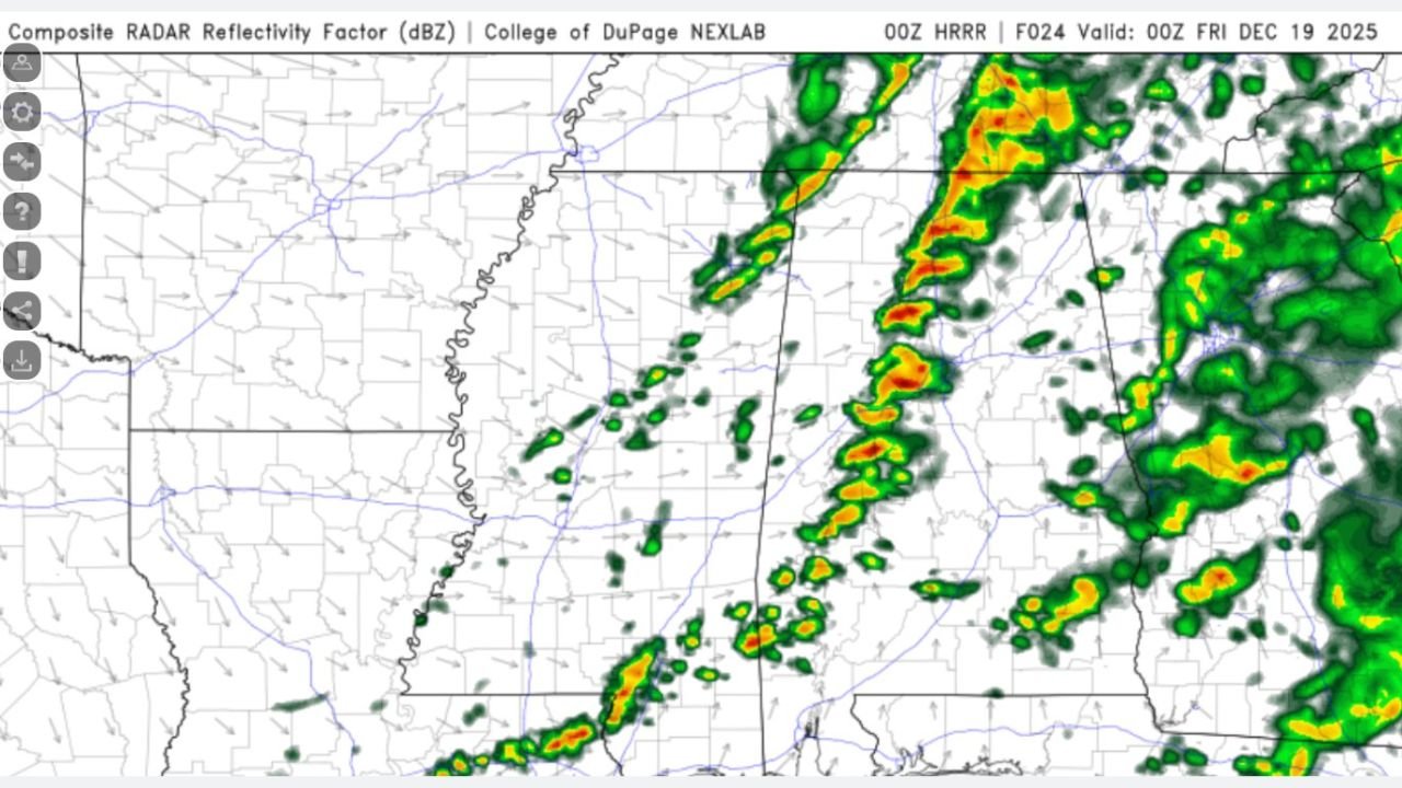
Forecast guidance and high-resolution model data indicate a broken line of storms moving east across Mississippi and into central portions of Alabama, including areas near Tuscaloosa, Birmingham, Montgomery, and surrounding counties, during the late evening and overnight timeframe.
Why Central Alabama Is the Focus Tonight
The concern centers on a low-instability, high-shear environment, a classic setup for nighttime “sleeper” tornado events. Radar and model imagery show scattered storms organizing into clusters as they approach Alabama, with strong low-level wind shear increasing after sunset.
Even though instability remains modest, wind profiles are supportive of rotation, especially within any storms that can briefly intensify or remain discrete ahead of the main line. This type of setup often produces short-lived tornadoes with little warning, making overnight awareness especially important.
What the Radar and Models Are Showing
High-resolution guidance highlights:
- Clusters of thunderstorms entering west-central Alabama late tonight
- Enhanced low-level wind shear (500–850 mb crossover) supportive of brief storm rotation
- Storms embedded within rain, making tornadoes harder to visually detect
- Strong southerly surface winds backing slightly overnight, increasing directional shear
These factors combine to raise concern for isolated tornado development, even if storms do not appear particularly intense on radar at first glance.
Timing and Areas Most at Risk
The window of concern spans roughly:
- 10 PM Thursday through 4 AM Friday
Areas most favored include:
- West-central and central Alabama
- Counties along and east of the Mississippi-Alabama border initially, shifting east overnight
- Urban corridors where overnight warnings may be harder to notice
Storms should gradually weaken toward sunrise as the system shifts east and instability decreases.
What to Expect Overall
It’s important to emphasize that this is not expected to be a widespread tornado outbreak. However, the risk is non-zero, and history shows that even marginal setups like this can produce isolated but impactful tornadoes, especially at night.
Primary hazards include:
- Brief tornadoes
- Localized damaging wind gusts
- Heavy rain and frequent lightning
Why This Is Called a “Sleeper” Threat
Sleeper events are dangerous because:
- Storms occur overnight while people are asleep
- Tornadoes may form quickly with little lead time
- Storms may not look severe until rotation suddenly develops
This is why forecasters are urging residents in central Alabama to remain weather-aware, even if conditions seem quiet initially.
What Residents Should Do Tonight
- Ensure multiple ways to receive weather warnings, including NOAA weather radios and smartphone alerts
- Know where to take shelter if a warning is issued
- Do not rely solely on outdoor sirens, especially overnight
- Avoid dismissing warnings due to “just rain” appearances
Looking Ahead
Storms will move out of Alabama by Friday morning, with quieter conditions expected later in the day. Additional weather systems may impact the region again later this weekend, but tonight’s concern remains focused on isolated overnight tornado potential.
WaldronNews.com will continue monitoring updates and provide additional coverage if watches or warnings are issued. Stay alert and stay safe.