
Central and Southern Illinois Brace for Multiple Rounds of Heavy Rain and Strong Storms as 3–5 Inches Fall South of I-70 Through the Weekend
UNITED STATES — Forecast models remain consistent in showing a wet and potentially stormy stretch across the Midwest this week, with the heaviest rainfall targeting central and southern Illinois before spreading more broadly through the region late in the week.
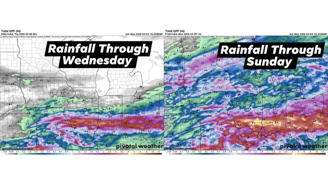
The latest projections indicate that most rainfall through Wednesday will concentrate south of the Interstate 70 corridor, where repeated rounds of showers and thunderstorms could bring significant totals.
Heaviest Rain Through Wednesday Focused on Southern Illinois
Rainfall guidance through midweek shows a pronounced band of heavier totals extending across:
- Southern Illinois
- Western Kentucky
- Southeast Missouri
- Southern Indiana
Central and southern Illinois sit in the core of this heavier axis, with localized totals exceeding 2 to 3 inches possible by Wednesday morning.
Northern Illinois, including areas closer to the Wisconsin border, appear to remain largely north of the main rain band early in the event.
Action Expands Thursday Through Saturday
By Thursday, the system broadens and additional rounds of showers and thunderstorms move into more of Illinois and surrounding states.
From Thursday through Saturday, several waves of precipitation are expected to track across:
- Illinois
- Indiana
- Missouri
- Kentucky
- Ohio
This extended period of unsettled weather increases the risk for locally higher totals, particularly in areas that experience repeated thunderstorm development.
Severe Threat Friday Into Friday Night
Forecast guidance suggests that Friday afternoon into Friday night may present the most organized severe weather risk.
Primary concern:
- Damaging wind gusts
Lower but not zero risk:
- Isolated tornado potential
This threat would develop ahead of a cold front expected to move through the region on Saturday.
Highs Climbing Into the 70s Before the Front
Ahead of the approaching cold front, temperatures across parts of Illinois could climb into the 70s, especially in central and southern sections of the state.
This warmer air mass will help fuel thunderstorm development before the front pushes through and cooler air follows.
Rainfall Totals Through Sunday
Expanded rainfall projections through Sunday show a broader area of moderate totals across much of Illinois and neighboring states.
Southern portions of Illinois remain favored for the highest accumulations, with some model guidance indicating localized amounts exceeding 3 to 5 inches over the entire event window.
Repeated rounds of storms could lead to:
- Ponding on roadways
- Minor flooding in low-lying areas
- Rapid rises on small streams
What This Means for Arkansas
While the heaviest rainfall focus is north of Arkansas, large-scale storm systems tracking through Illinois often originate from broader regional dynamics that can influence weather across the central United States.
For Arkansas residents, this highlights an active early-March pattern with repeated frontal systems moving through the Midwest and Ohio Valley.
Bottom Line
- Heaviest rain through Wednesday centered on central and southern Illinois
- Several additional storm rounds Thursday through Saturday
- Severe threat Friday afternoon and night, mainly damaging winds
- Highs may reach the 70s before Saturday’s cold front
- Another severe weather chance possible next Tuesday
For continued updates on evolving Midwest storm systems and how broader regional weather patterns may impact Arkansas conditions, stay with WaldronNews.com for in-depth forecast coverage and analysis.