
Central Kansas and Central Oklahoma Targeted for Possible 30% Enhanced Severe Risk Friday as Multi-Day Plains Outbreak Eyes Arkansas Next
UNITED STATES — The Storm Prediction Center (SPC) may soon upgrade portions of Central Kansas and Central Oklahoma to an Enhanced (30%) severe weather risk for Friday, marking what could become the most volatile day in an already active multi-day Plains storm pattern.
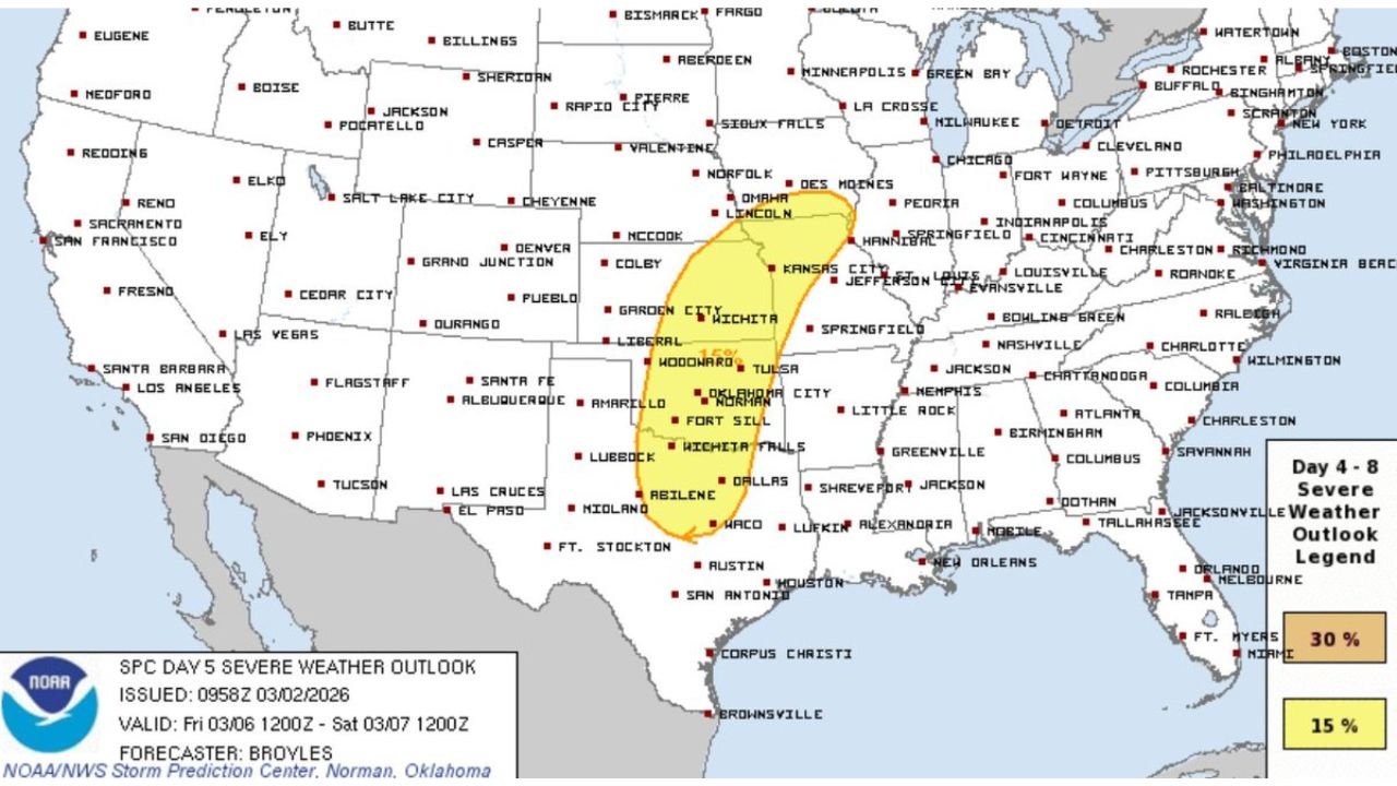
New outlook data shows a 15% severe probability stretching from Dallas and Abilene, Texas, northward through Oklahoma City, Tulsa, Wichita, and into central Kansas near Lincoln and Kansas City. Forecasters indicate confidence is increasing that part of this corridor — likely from central Kansas into central Oklahoma — could see an upgrade in the next outlook cycle.
Friday Emerging as the Main Event
The Day 5 outlook valid Friday highlights a north-south oriented risk zone covering:
- Abilene and Dallas, Texas
- Oklahoma City and Norman, Oklahoma
- Wichita, Kansas
- Kansas City metro area
- Toward Lincoln, Nebraska
Model guidance shows strengthening upper-level jet energy moving into the central Plains. A 500mb wind analysis indicates a powerful mid-level jet streak overspreading the region Friday afternoon and evening — a classic ingredient for organized severe thunderstorms.
Ingredients Coming Together
Surface and instability projections show:
- Increasing moisture return from the Gulf
- Strong wind shear profiles across central Oklahoma and Kansas
- Favorable instability values developing by late afternoon
The overlap of instability and wind shear is often where Enhanced risk upgrades occur. Central Oklahoma into central Kansas appears positioned near that overlap zone.
Primary threats could include:
- Large hail
- Damaging straight-line winds
- Increasing tornado potential if low-level wind fields strengthen
Why Arkansas Should Watch This Closely
While the highest probabilities currently sit west of Arkansas, storm systems in this setup typically track northeast.
That puts areas such as:
- Tulsa
- Fort Smith
- Northwest Arkansas
- Waldron and the Arkansas River Valley
within potential downstream influence depending on how Friday’s system evolves and how far east instability spreads.
If storms consolidate into a strong squall line or supercell clusters, they could push east toward western Arkansas late Friday night or early Saturday.
Multi-Day Pattern Still in Play
This is not a one-day spike. The broader Plains pattern has already shown:
- Repeated storm development across Texas
- Gradual northward shift into Oklahoma and Kansas
- Strengthening upper-level support by Friday
Each day reinforces moisture transport and boundary placement, setting the stage for a potentially more organized severe event by week’s end.
What This Means for Western Arkansas
For Waldron and surrounding Scott County communities:
- Friday appears to be the day to monitor most closely
- Storm timing could extend into overnight hours
- Exact eastward extent will depend on warm front placement and instability recovery
Even if Arkansas remains just east of the highest probabilities, strong Plains systems often expand beyond initial outlook areas as confidence grows.
Bottom Line
- 15% severe risk currently outlined from North Texas to central Kansas
- Potential 30% Enhanced upgrade likely from central KS into central OK
- Strong jet dynamics and increasing instability Friday
- Arkansas remains just east of the primary zone but could see impacts
This late-week system has the makings of the most significant severe weather day in this stretch. Stay with WaldronNews.com for updates as SPC outlooks evolve and we refine how this Plains outbreak may affect western Arkansas.