
Central Mississippi and Alabama Face “Sneaky” Tornado Setup as Jackson, Meridian and Tuscaloosa Sit Beneath Subtle but Favorable Evening Storm Environment
MISSISSIPPI — A subtle but potentially concerning tornado setup is taking shape across central Mississippi into west-central Alabama Thursday evening, with areas including Jackson, Meridian, Tuscaloosa and Birmingham positioned near a narrow corridor of enhanced storm ingredients.
Forecasters are describing the threat as “sneaky” — not because the environment looks explosive at first glance, but because storm motion relative to the wind profile may compensate for otherwise modest wind shear.
Storm Line Targeting Central Mississippi Into Alabama
High-resolution model reflectivity shows a broken but organized band of thunderstorms extending from:
- Near Greenville, Mississippi
- Through Jackson and Meridian
- Into Tuscaloosa and Birmingham, Alabama
- Eastward toward LaGrange and Peachtree City, Georgia
The strongest simulated cells appear embedded within this west-to-east oriented corridor, particularly near:
- Jackson, MS
- Tuscaloosa, AL
- Birmingham, AL
While widespread discrete supercells are not evident, embedded rotating segments within the line cannot be ruled out.
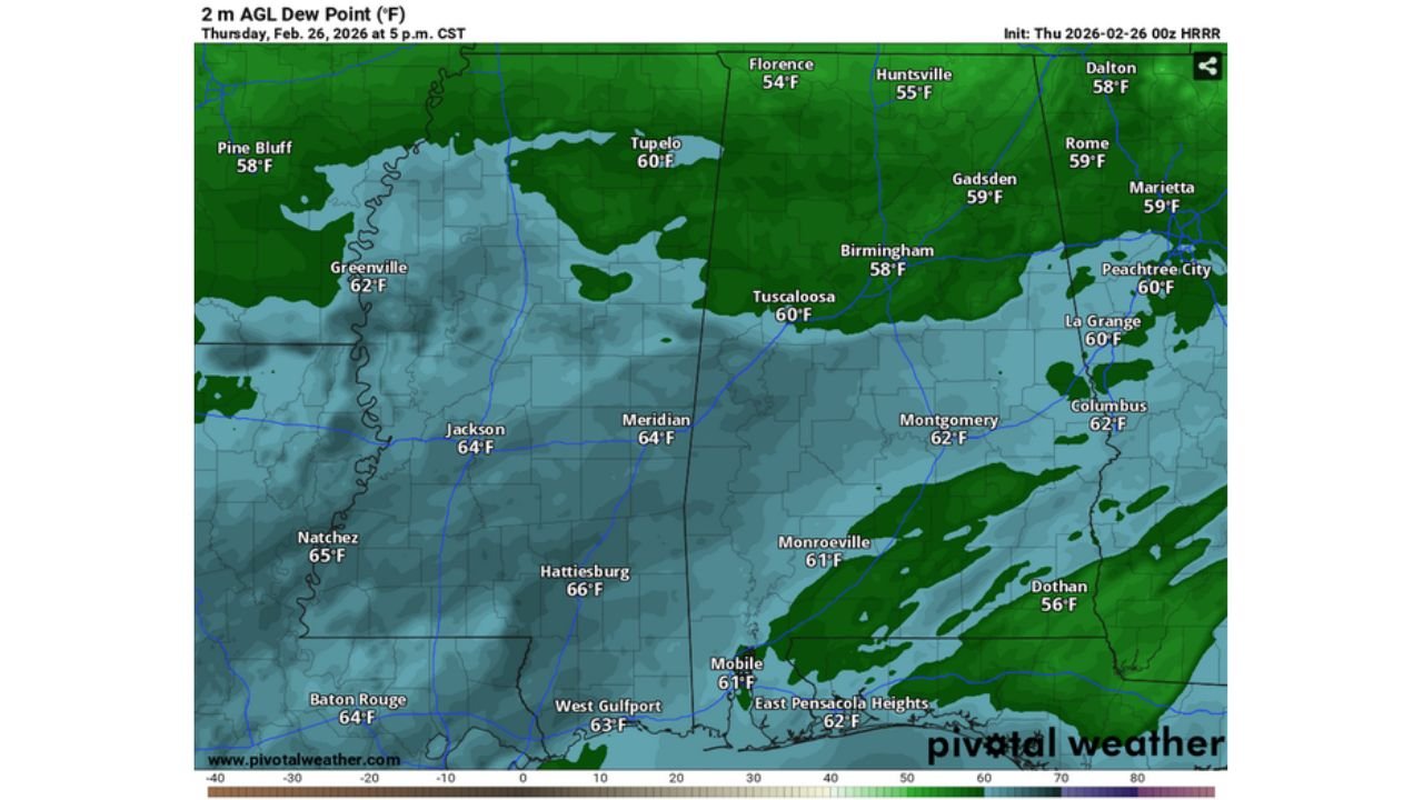
Moisture In Place Across Mississippi and Alabama
Dew point projections at 2 meters show mid-60s moisture pooling across:
- Jackson (64°F)
- Meridian (64°F)
- Hattiesburg (66°F)
- Montgomery (62°F)
- Columbus, GA (62°F)
Moisture is sufficient to support instability, particularly across central and southern Mississippi into west Alabama.
Instability and 3CAPE Raising Eyebrows
Surface-based CAPE values are moderate across the region, with stronger instability focused along and south of the main storm band.
Of particular note: 3CAPE values exceeding 200 J/kg in localized areas.
3CAPE (low-level convective available potential energy) is often associated with stretching potential in the lowest levels of the atmosphere — a parameter sometimes linked to tornado formation in marginal shear environments.
This is where the “sneaky” aspect comes into play.
Weak Shear — But Storm Motion May Help
Wind shear across central Mississippi and Alabama is not especially strong compared to classic high-end tornado setups.
However, hodograph analysis suggests:
- Storm motion relative to boundary-layer winds may locally enhance low-level rotation
- Merging cells or rear-flank downdraft (RFD) interactions could tighten circulation
- Effective low-level directional shear may be just enough for brief tornado potential
In other words, even with weak background shear, localized processes could compensate.
Cities Under the Greatest Concern
The corridor of interest includes:
Mississippi
- Greenville
- Jackson
- Meridian
Alabama
- Tuscaloosa
- Birmingham
- Montgomery
Storm timing suggests activity peaking during the late afternoon into early evening hours.
Why This Setup Is Easy to Overlook
This does not resemble a textbook high-risk tornado outbreak:
- Wind shear is modest
- Storm mode appears semi-linear
- Instability is not extreme
But subtle enhancements — especially in low-level buoyancy and storm-relative wind — can occasionally produce brief tornadoes in environments that appear unimpressive on broader-scale maps.
These are often the types of setups that catch people off guard.
Bottom Line
Central Mississippi and west-central Alabama, including Jackson, Meridian, Tuscaloosa and Birmingham, may face a low-end but non-zero tornado threat Thursday evening.
While wind shear is weak overall, favorable storm motion and localized low-level instability — including 3CAPE values above 200 — could support brief spin-ups within a developing storm line.
Residents across central Mississippi and Alabama should remain weather-aware this evening despite the lack of a classic high-end severe setup.
Stay with WaldronNews.com for continued severe weather monitoring and regional updates.