
Central Oklahoma and North Texas on Edge: 95% Watch Probability as Tornadoes, Destructive Winds, and Giant Hail Threaten This Evening
OKLAHOMA CITY, OKLAHOMA — The Storm Prediction Center has issued a Mesoscale Discussion covering much of central Oklahoma into western North Texas, signaling a rapidly escalating severe weather setup that could bring tornadoes, destructive winds, and very large hail over the next several hours.
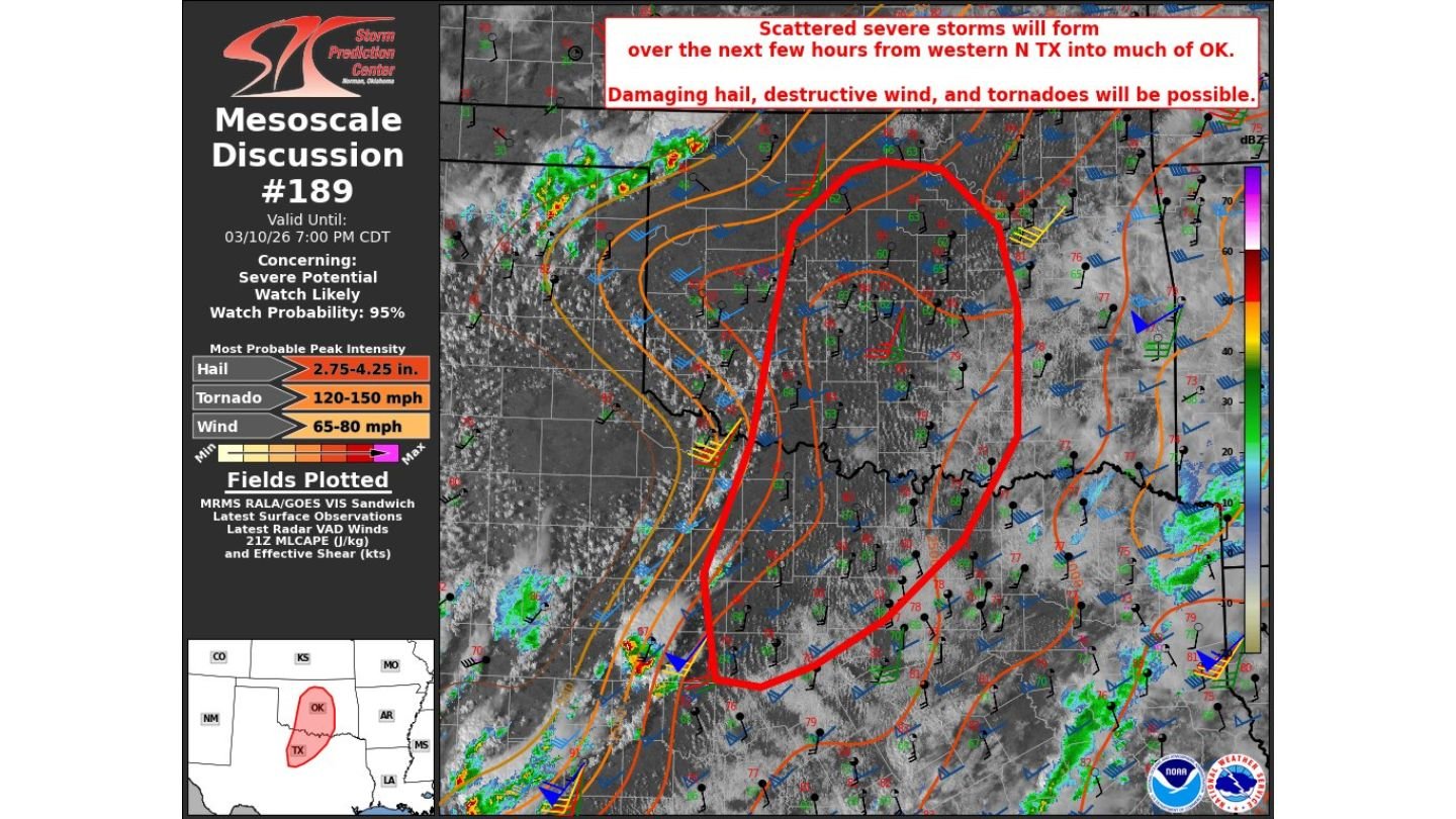
According to Mesoscale Discussion #189, a severe thunderstorm or tornado watch is likely, with forecasters placing the probability of a watch issuance at 95 percent. That high percentage reflects strong confidence that scattered severe storms will develop soon across the highlighted region.
Atmosphere Primed Along the Dryline
The discussion area stretches from western North Texas northward through central Oklahoma, including communities near the Red River and extending toward the Oklahoma City metro.
Meteorologists note that the atmosphere is already primed along and east of the dryline. Warm, humid air is firmly in place, and there is little remaining “cap” — the layer of warm air aloft that can suppress storm development. With minimal inhibition left, thunderstorms are expected to ignite over the next few hours.
Once storms form, conditions strongly favor rotating supercells, the type of storms most capable of producing tornadoes and giant hail.
Tornado Threat Increasing This Evening
Wind shear is forecast to intensify through the evening hours, which will enhance the tornado risk. Forecasters indicate that the greatest risk for a strong tornado will occur during the early phase of storm development — before storms begin merging into a larger complex later tonight.
The Mesoscale Discussion highlights the potential for tornado wind speeds in the 120–150 mph range, indicating that any tornado that forms could become significant.
Residents across central Oklahoma, including areas between the Red River and northward toward the I-40 corridor, should be prepared for rapidly changing conditions this evening.
Giant Hail and Destructive Winds Also Possible
In addition to tornadoes, the environment supports extremely large hail. Steep temperature drop-offs aloft combined with abundant moisture could allow some supercells to produce hail in the 2.75 to 4.25 inch range — potentially approaching softball size.
Destructive wind gusts are also a concern, with projected wind speeds of 65 to 80 mph possible in the strongest storms.
This combination of hazards — tornadoes, giant hail, and damaging winds — makes this a particularly volatile setup.
Storm Evolution Matters
Forecasters emphasize that storm mode will be critical. Early discrete supercells pose the highest tornado and giant hail threat. As the evening progresses, storms may begin to merge into clusters or a larger line, shifting the primary threat more toward widespread damaging winds.
However, the window before that transition could feature the most intense and potentially dangerous storms of the day.
What This Means for Arkansas Readers
Although the highest immediate risk is centered over central Oklahoma and western North Texas, systems developing in this region often track eastward overnight. Depending on storm evolution, parts of Arkansas could see impacts later if storms maintain strength.
Waldron and surrounding communities should stay alert to updates, particularly if watches are issued and storms organize into a longer-lived complex moving east.
Residents within the current discussion area are urged to:
- Monitor local warnings closely
- Review tornado safety plans
- Ensure multiple ways to receive alerts
- Be ready to act quickly if warnings are issued
With a 95 percent watch probability and conditions strongly favoring supercells, the next several hours across central Oklahoma and western North Texas could become increasingly dangerous.
WaldronNews.com will continue monitoring developments as watches and warnings are issued and storms begin to intensify.