
Central Texas Faces Historic “CIG 2” Hail Risk as SPC Warns of Long-Tracked Supercells Capable of Producing Baseball-Plus Size Hail
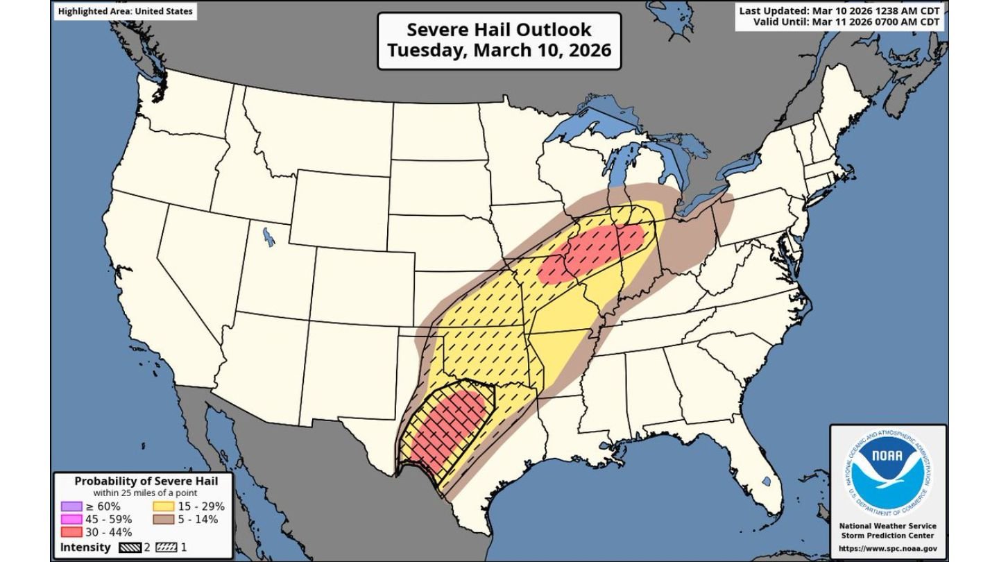
CENTRAL TEXAS — For the first time in Storm Prediction Center history, a Category 2 (CIG 2) Hail Risk has been introduced for parts of Central Texas, signaling an unusually high-end threat for destructive hail on Tuesday, March 10, 2026.
The Severe Hail Outlook highlights a focused zone stretching across Central Texas where atmospheric conditions strongly favor long-tracked supercells capable of producing hailstones larger than 3.5 inches in diameter — potentially exceeding baseball size.
This type of outlook upgrade is rare and underscores the seriousness of the developing setup.
What the “CIG 2” Hail Risk Means
A CIG 2 Hail Risk designation indicates a concentrated corridor where ingredients are aligned for significant hail production. In this case, forecasters are concerned about:
- Persistent rotating supercells
- Strong updraft speeds
- Extremely favorable hail growth zones aloft
When storms maintain rotation and remain isolated, they can repeatedly cycle hailstones through powerful updrafts, allowing them to grow larger with each pass through the storm core. The result can be very large, damaging hailstones capable of shattering windshields, destroying roofs, and severely damaging crops and vegetation.
The highlighted zone across Central Texas carries the highest probability of intense hail within 25 miles of a point.
Long-Tracked Supercells Expected
Forecast guidance indicates storms that develop over Central Texas may become long-lived and track northeastward along a broader severe corridor extending from Texas through portions of Oklahoma, Arkansas, Missouri, Illinois, and into the Midwest.
While the most extreme hail threat is centered in Central Texas, a broader region from the Southern Plains into the Mid-Mississippi Valley also carries elevated hail probabilities.
However, the core of the concern remains in Central Texas, where the CIG 2 designation has been placed.
Hail Larger Than 3.5 Inches Possible
Hailstones exceeding 3.5 inches in diameter are considered destructive and potentially dangerous. At that size:
- Vehicles can sustain major body damage
- Windshields can be completely shattered
- Roofs and siding may suffer structural damage
- Outdoor plants and crops can be stripped or destroyed
Residents in the highlighted Central Texas corridor are urged to prepare in advance. Once storms begin producing hail of this magnitude, damage can occur within seconds.
Timing and Preparedness
The Severe Hail Outlook is valid through early Wednesday morning, indicating storms may continue into the overnight hours.
Residents should:
- Move vehicles into garages or covered structures
- Secure outdoor furniture and equipment
- Protect sensitive plants where possible
- Remain indoors during active warnings
Large hail can fall rapidly and without prolonged lead time, especially with isolated supercells.
A Rare Outlook Upgrade
The addition of a CIG 2 Hail Risk for Central Texas represents a historic move by the Storm Prediction Center. Such upgrades are not issued lightly and reflect strong confidence in a high-end hail environment.
While severe weather threats extend northeastward beyond Texas, Central Texas remains the focal point for the most intense hail potential.
WaldronNews.com will continue monitoring updates as storms begin to develop and track across the region. Residents in Central Texas should remain weather aware throughout the day and evening as this rare and potentially destructive hail setup unfolds.