
Central U.S. Placed on Extended Severe Weather Watch as Multi Day Storm Threat Targets Texas Oklahoma Kansas Missouri Illinois and Beyond Through Next Wednesday
UNITED STATES — A prolonged and increasingly concerning severe weather pattern is now taking shape across the central United States, with multiple days of storm risks outlined from Friday through next Wednesday.
This is not a one-day event. Instead, the latest outlook shows a continuous stretch of severe weather potential shifting across the Plains into the Midwest, raising concerns that some days next week could bring the highest-impact storms of this entire pattern.
Day by Day Breakdown of the Expanding Risk
The evolving storm threat will move and intensify over several days:
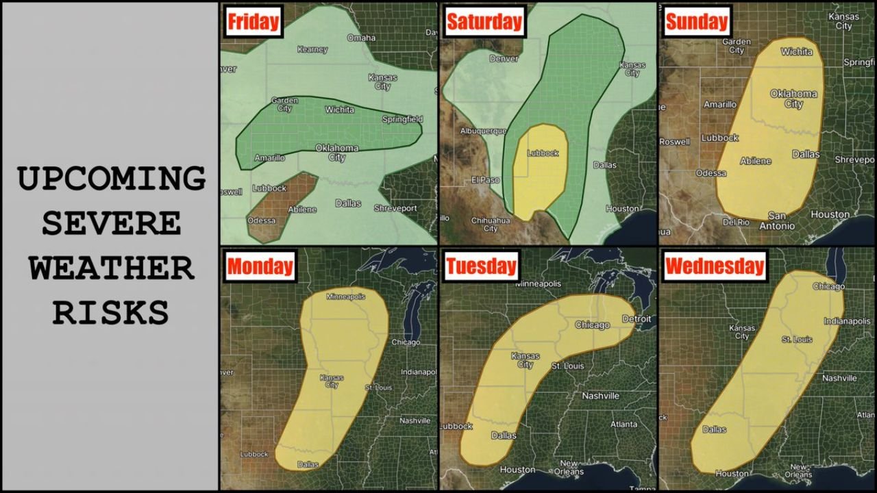
Friday:
Storm chances begin across parts of Kansas and Oklahoma, with a broader area of general thunderstorms and a localized severe risk developing.
Saturday:
The focus shifts south and west, with a more concentrated risk zone emerging near west Texas and southeastern New Mexico, including areas around Lubbock.
Sunday:
A more organized and widespread severe threat develops across Texas and Oklahoma, including Dallas, Abilene, Oklahoma City, and Wichita. This is one of the first days where a larger-scale severe setup becomes more apparent.
Monday:
The system lifts north, bringing storms into Kansas, Nebraska, and possibly Iowa, with cities like Kansas City and nearby regions under increasing threat.
Tuesday:
The risk expands northeast into the Midwest, targeting areas including Missouri, Illinois, and possibly Chicago, while still impacting parts of the southern Plains.
Wednesday:
The storm corridor stretches further east, impacting Missouri, Illinois, Indiana, and surrounding regions, including St. Louis and Indianapolis, with continued severe potential.
Why This Stretch Is So Important
This pattern stands out because of its duration and consistency. Instead of a single outbreak:
- Storms are expected to redevelop daily along shifting boundaries
- The risk area will move north and east over time
- Some days next week could have a higher ceiling for severe weather intensity
That means even if one area avoids storms one day, it could still be impacted the next.
Main Threats Expected
Across this multi-day setup, conditions will support:
- Large hail
- Damaging wind gusts
- Potential tornado development
- Periods of heavy rainfall in some regions
The combination of instability, moisture, and strong wind energy will allow storms to become organized and potentially long-lived.
Plains to Midwest Corridor in Focus
The primary corridor of concern includes:
- Texas
- Oklahoma
- Kansas
- Missouri
- Illinois
- Parts of the Midwest and Great Lakes
Major population centers across this region could face multiple rounds of storms, increasing the overall impact.
What Residents Should Do Now
With an extended severe weather pattern ahead:
- Stay updated with daily forecast changes
- Have a severe weather plan ready for multiple days
- Ensure access to weather alerts at all times
- Be prepared for rapidly changing conditions, especially next week
Bottom Line
A very active stretch of severe weather is now on the table across the central United States.
From Friday through next Wednesday, the threat will shift, evolve, and potentially intensify, with some of the most impactful days still ahead.
This is the kind of pattern where staying alert every day matters, not just during a single storm event.