
Charlotte, North Carolina Faces Early-March Temperature Whiplash as 40s Chill Gives Way to 80° Spring Heat Wave Within Days
CHARLOTTE, NORTH CAROLINA — A dramatic early-March temperature swing is unfolding across the Carolinas, with a brief shot of late-winter chill followed almost immediately by a surge into full spring warmth — including multiple days near or above 80 degrees.
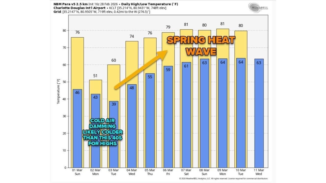
New forecast data centered on Charlotte Douglas International Airport (KCLT) highlights just how sharp the transition will be between March 1 and March 11.
Early Week Cool-Down: Cold Air Damming Brings 40s and 50s
The forecast shows a noticeable drop in temperatures at the start of the week, driven by a classic cold air damming setup east of the Appalachian Mountains.
Projected daily highs and lows:
- March 1 (Sunday): 76° / 46°
- March 2 (Monday): 51° / 43°
- March 3 (Tuesday): 60° / 39°
- March 4 (Wednesday): 74° / 48°
Monday’s high of 51° represents a steep 25-degree drop from Sunday’s 76°. Tuesday morning dips to 39°, marking the coldest low of the stretch.
Cold air damming often traps shallow, dense cool air against the mountains, leading to stubbornly chilly daytime highs — sometimes colder than models initially suggest. The data even notes that highs could end up in the 40s if the wedge strengthens more than expected.
Cloudy skies and cool northeast flow typically accompany this pattern.
Rapid Rebound: Spring Heat Builds Quickly After March 4
The turnaround begins midweek and accelerates rapidly.
Forecast highs climb steadily:
- March 5 (Thursday): 76° / 55°
- March 6 (Friday): 79° / 59°
- March 7 (Saturday): 81° / 61°
- March 8 (Sunday): 80° / 63°
- March 9 (Monday): 81° / 64°
- March 10 (Tuesday): 80° / 64°
- March 11 (Wednesday): 80° / 63°
By next weekend, Charlotte is projected to experience a full-fledged spring heat wave, with multiple days reaching or exceeding 80°.
That’s a swing of roughly 30 degrees warmer compared to early-week highs.
Overnight lows also moderate significantly, rising into the upper 50s and low-to-mid 60s — a clear sign that the cold air mass has completely retreated.
Why Such a Dramatic March Swing?
Early March is notorious for volatile weather patterns across the Southeast.
Key drivers behind this type of flip include:
- Strong frontal boundaries moving through the region
- High pressure building north of the Carolinas (cold air damming)
- A shifting jet stream pattern
- Rapid return of Gulf moisture and southerly flow
Once the cold high pressure system shifts offshore, winds turn southerly and warm air surges north quickly. That transition appears to occur between March 4 and March 6 in this forecast cycle.
A Classic “Two Days of Winter, Then Back to Spring” Pattern
The forecast perfectly captures what many meteorologists call the most “March-like” scenario possible:
- Warm start
- Sudden chill
- Then a sharp and sustained warm-up
Within less than a week, temperatures go from lows near freezing and highs in the 50s… to sustained 80-degree afternoons.
Residents across Charlotte and the surrounding Piedmont should prepare for quick wardrobe changes — jackets early in the week, short sleeves by the weekend.
As is typical in March, the atmosphere is transitioning rapidly, and swings like this are a reminder that winter and spring often battle it out before one fully takes control.