
Coastal Snowstorm Threat Targets I-95 Corridor From Washington, D.C. to New York and Boston, With Blizzard Conditions Possible but Track Still Uncertain
MID-ATLANTIC AND NORTHEAST — A coastal snowstorm remains possible for the I-95 corridor and surrounding areas Sunday into Monday, but confidence in exact snowfall totals is still low. Forecasters caution that the track and speed of intensification will determine whether this becomes a moderate coastal event or a more disruptive winter storm with blizzard conditions near the shoreline.
Current guidance suggests the storm’s behavior is trending closer to what the European model has been indicating — though perhaps with slightly stronger impacts along the coast.
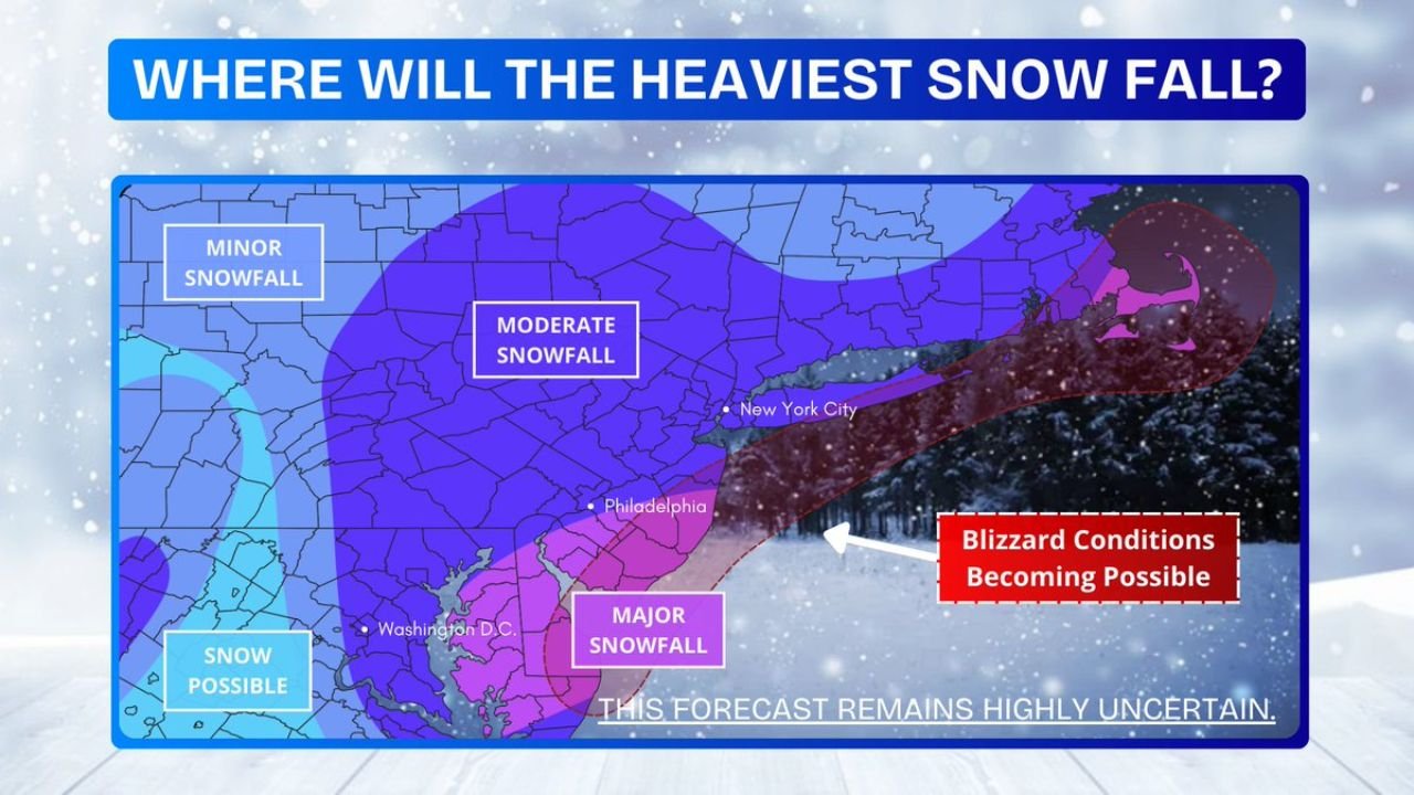
Heaviest Snow Focus: Eastern Pennsylvania to Coastal New England
The latest assessment highlights three broad snowfall zones:
- Major Snowfall Zone: From the Washington, D.C. metro through Baltimore, Philadelphia, central and southern New Jersey, New York City, and into southern New England.
- Moderate Snowfall Zone: Extending inland across much of central Pennsylvania, northern New Jersey, interior New York, and parts of upstate New York.
- Minor Snowfall Zone: Farther west into western Pennsylvania and portions of the interior Northeast.
The highest-impact corridor currently appears to run from Philadelphia through New York City and into parts of Connecticut and Massachusetts, with coastal sections facing the greatest risk for stronger snowfall rates.
3–6 Inches Inland, 6–12 Inches Near Coast
At this stage, a reasonable working forecast suggests:
- 3–6 inches away from the immediate coastline
- 6–12 inches closer to the coast
That places much of eastern Pennsylvania and interior New Jersey in the moderate range, while coastal New Jersey, Long Island, and possibly eastern Massachusetts could see higher totals if the storm strengthens more aggressively.
However, these numbers are far from locked in.
Inverted Trough Could Boost Totals in Central Pennsylvania and Maryland
Some model guidance — notably RGEM — continues to show an inverted trough developing inland. If that feature materializes, snowfall totals could increase across central Pennsylvania into parts of Maryland, even if the main coastal low remains offshore.
That scenario would expand heavier snowfall farther west than currently projected.
NYC: Wide Range of Outcomes
New York City remains in one of the most sensitive forecast zones. Depending on exact storm evolution:
- Totals could remain in the lower 3–5 inch range
- Or jump to 8 inches or more if the low tracks slightly closer and deepens faster
A shift of even 50 miles could significantly alter snowfall expectations across the metro area.
Blizzard Conditions Possible Near Coast
The map also highlights the potential for blizzard conditions near the coast if the storm strengthens sufficiently. That would require:
- Sustained winds of 35 mph or higher
- Falling and blowing snow
- Reduced visibility
While not guaranteed, coastal New Jersey, Long Island, and parts of southern New England would be the most vulnerable if this higher-end scenario unfolds.
Bottom Line: Forecast Highly Uncertain
Forecasters emphasize that the setup remains highly uncertain and that changes are likely. The GFS solution appears overly amplified at this time, while the Euro-like solution remains the more realistic baseline — though with some added “oomph” possible.
Residents from Washington, D.C. through Philadelphia, New York City, and Boston should continue monitoring updates closely. The difference between moderate accumulations and a high-impact coastal snowstorm will come down to subtle shifts in track and storm phasing over the next 24–36 hours.
Stay with Waldronnews.com for the latest updates as the Sunday–Monday coastal snow threat evolves.