
Cold Pattern Rebuilds Across New England, New York and Great Lakes as -WPO Returns, Signaling Below-Average Temperatures Into Late February
UNITED STATES — Any brief moderation in temperatures across the Northeast may prove short-lived, as long-range ensemble guidance shows another surge of cold air poised to spill south from Canada into New England, New York and the Great Lakes toward the final week of February.
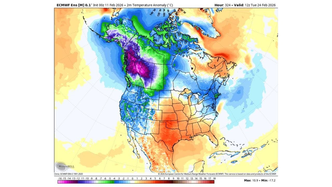
Latest extended-range model data valid around February 24 through early March indicates a renewed colder-than-average pattern developing across much of the northern and eastern United States.
Cold Air Reloads Over Canada and Western North America
Temperature anomaly maps show significant negative departures across:
- Western and central Canada
- The Canadian Prairies
- Portions of British Columbia and Alberta
Deep cold pooling over western Canada is often a key ingredient for downstream cold intrusions into the northern United States.
At the same time, a negative phase of the West Pacific Oscillation (-WPO) appears to redevelop, a pattern that typically favors:
- Ridge development near Alaska
- A trough carving southward into central and eastern North America
- Increased opportunities for Arctic air to move into the U.S.
Below-Average Temperatures Favored in New England and Great Lakes
Forecast 2-meter temperature anomalies show widespread below-normal conditions across:
- Maine
- New Hampshire
- Vermont
- Massachusetts
- Connecticut
- Rhode Island
- Upstate and Western New York
- Pennsylvania
- Ohio
- Michigan
- Wisconsin
- Minnesota
While the Southeast and parts of Texas show warmer anomalies at times, the northern tier and Northeast lean colder as we approach late February.
This setup argues against a sustained warm-up for New England and surrounding states.
Upper-Level Trough Reinforces Winter Pattern
500mb height anomaly guidance supports the colder signal, showing:
- A trough centered over central and eastern Canada
- Lower heights extending into the Great Lakes and Northeast
- Ridging positioned farther west over the Pacific and parts of the western U.S.
This upper-level configuration is consistent with recurring cold shots rather than a prolonged mild regime.
What This Means for the Northeast
For residents in:
- Boston
- Hartford
- Providence
- Albany
- Buffalo
- Cleveland
- Detroit
- Pittsburgh
The data suggests:
- Temperatures may continue running below mid- to late-February averages.
- Any brief warm spells are likely temporary.
- Additional opportunities for winter weather remain possible if storm systems align with the colder air mass.
No Sustained Warm Pattern Yet
Despite occasional short-term moderation, there is little indication in extended guidance of a durable spring-like shift across New England.
With substantial cold air reservoir available in Canada and a favorable teleconnection pattern developing, the broader winter regime appears intact heading into late February.
Waldronnews.com will continue tracking ensemble trends to see whether this colder outlook strengthens or if signals shift toward a more balanced pattern as March approaches.