
Colorado and Wyoming Face Extreme Fire Weather as Powerful Windstorm Triggers PDS Red Flag Warning
DENVER, COLORADO — Extremely dangerous fire weather conditions are unfolding today across Colorado and Wyoming, as a powerful windstorm combines with very low humidity and dry fuels, prompting the National Weather Service and Storm Prediction Center to issue a Particularly Dangerous Situation (PDS) Red Flag Warning for large portions of the region.
Forecasters warn that any fire that starts today could spread rapidly and become uncontrollable in a very short time, even from a small spark. The threat is considered high-end and unusual for December, driven by an intense atmospheric setup more typical of spring or early fall.
Why Today’s Fire Risk Is So Dangerous
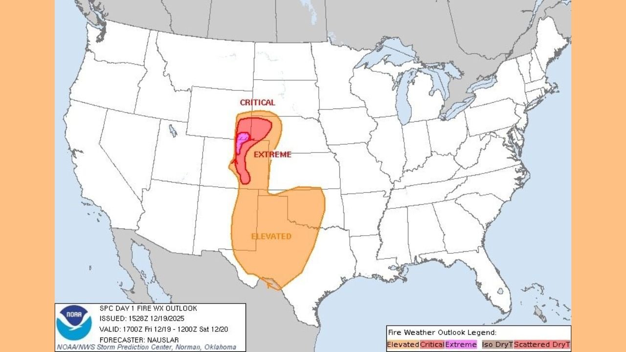
According to the Storm Prediction Center’s Day 1 Fire Weather Outlook, extreme fire danger is focused along the Colorado and Wyoming Front Range, where multiple critical factors are coming together at the same time.
Key ingredients include:
- Very strong winds, with gusts capable of exceeding 60–70 mph, especially in foothills and wind-prone corridors
- Exceptionally low relative humidity, dropping into the single digits and near 10%
- Unseasonably warm temperatures, drying out vegetation further
- Dry fuels, including grasses and dormant vegetation that can ignite easily
This combination creates conditions where fires can ignite quickly, spread explosively, and outrun suppression efforts.
Areas Most at Risk
Based on the latest outlook data:
- Extreme fire weather is centered along parts of eastern Wyoming and northern Colorado, including Front Range communities
- Critical fire weather surrounds the extreme zone, extending farther south and north
- Elevated fire weather spreads across a broader area of the central Plains
These designations mean that fire behavior could escalate rapidly, even outside the core extreme zone.
Timing of the Threat
The highest fire danger is expected through the daytime hours today, coinciding with peak wind speeds and the lowest humidity levels. Winds will be strongest during the late morning and afternoon, when mixing allows stronger winds aloft to reach the surface.
Even after sunset, lingering winds may continue to pose problems in some locations.
What a PDS Red Flag Warning Means
A PDS Red Flag Warning is reserved for rare, high-impact fire weather events. It signals that:
- Fires may spread faster than emergency crews can respond
- Evacuations could become necessary with little notice
- Normal fire suppression tactics may be ineffective under extreme wind conditions
Officials stress that outdoor burning should be avoided entirely, and any activity that could produce sparks should be postponed.
Safety Guidance for Residents
Residents across Colorado and Wyoming are urged to take the threat seriously and follow safety precautions, including:
- Avoiding outdoor burning, welding, or using fire pits
- Securing tow chains, trailer equipment, and anything that could spark
- Properly extinguishing cigarettes
- Following local fire restrictions and emergency guidance
Emergency officials emphasize that awareness and prevention today can make the difference between a close call and a major wildfire.
What Happens Next
While fire conditions are expected to improve once winds decrease and humidity recovers, today remains a high-risk window. Authorities will continue to monitor conditions closely and may issue additional warnings if necessary.
Residents are encouraged to stay weather-aware and prepared until conditions improve.
For continued updates on fire weather and local safety alerts, stay with WaldronNews.com.