
Colorado and Wyoming Under Particularly Dangerous Fire Weather Warning Friday as 100-MPH Winds and Extremely Dry Air Threaten Rapid Wildfire Spread
COLORADO — Parts of Colorado and southern Wyoming are bracing for a Particularly Dangerous Situation (PDS) on Friday, December 19, as an intense windstorm combines with very dry air to create extremely critical fire weather conditions, according to the National Weather Service and Storm Prediction Center.
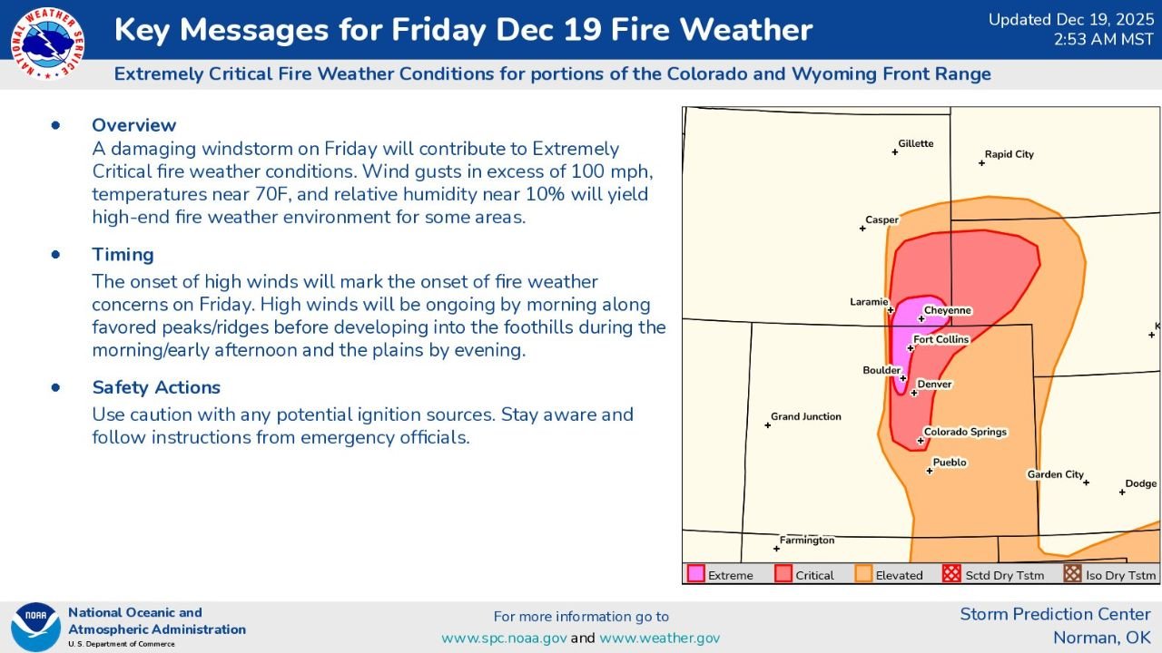
Forecast graphics issued early Friday morning show wind gusts exceeding 100 mph, relative humidity dropping near 10%, and unseasonably warm temperatures near 70 degrees, a combination that could allow any fire ignition to spread rapidly and uncontrollably, especially along the Front Range foothills.
Extremely Critical Fire Weather Setup Confirmed
Meteorologists warn that Friday’s setup meets the threshold for high-end fire weather, a classification rarely issued.
The affected corridor stretches across the Colorado Front Range, including areas near Fort Collins, Boulder, Denver, Colorado Springs, and Pueblo, and extends northward into southern Wyoming, including Cheyenne and nearby foothill zones.
The most dangerous conditions are expected along and west of Highway 93, where terrain-enhanced winds are forecast to peak.
Winds Over 100 MPH and Sustained Gusts Create Rapid Spread Risk
Forecast maps show maximum wind gusts ranging from 85 to 100 mph, with sustained winds of 45 to 55 mph possible for several hours.
These winds are expected to:
- Down trees and power lines
- Rapidly push any fire front
- Make firefighting efforts extremely difficult or impossible
Even small sparks could lead to fast-moving wildfires, particularly in grassy or foothill terrain.
Timing: Morning Foothills, Evening Plains
According to forecast timing data:
- High winds begin Friday morning along ridges and peaks
- Conditions expand into the foothills by late morning to early afternoon
- Plains areas become affected by evening
This progression increases concern for urban-wildland interface communities, where strong downslope winds can funnel directly into populated areas.
Officials Urge Immediate Fire Safety Awareness
Emergency officials stress that any ignition source could be dangerous, including:
- Outdoor burning
- Sparks from equipment
- Trailer chains
- Cigarettes
- Powerline failures
Residents are urged to avoid activities that could create sparks, secure loose objects, and remain alert to possible fire weather alerts or evacuation notices.
Why This Event Is Being Labeled “Particularly Dangerous”
The Particularly Dangerous Situation designation is reserved for events where multiple extreme factors overlap, including:
- Exceptional wind speeds
- Very low humidity
- Warm temperatures
- Dry fuels
Officials note there is uncertainty about how far east the strongest winds will reach, but if they move past Highway 93 and U.S. 36, impacts could expand significantly.
What Residents Should Do Now
Residents across Colorado and southern Wyoming should:
- Stay informed through official alerts
- Avoid outdoor fire use entirely
- Prepare for possible power outages
- Follow instructions from local emergency agencies
Conditions like these have historically led to large, fast-spreading fires in the region, making preparedness critical.
WaldronNews.com will continue monitoring updates from the National Weather Service and Storm Prediction Center and provide further coverage as conditions evolve. Stay with WaldronNews.com for the latest safety updates and regional weather alerts.