
Colorado Front Range Braces for Slushy Band of Snow Friday as Denver, Boulder and Fort Collins Expect Quick-Hitting Accumulations
COLORADO — A quick burst of wet, slushy snowfall is expected to move across Colorado’s Front Range on Friday, bringing banded snow and brief bursts of heavy snowfall during the morning and lunchtime commute. Forecasters say the event will likely be short-lived but could still create travel disruptions from Fort Collins through Boulder, Denver, Castle Rock, and Colorado Springs.
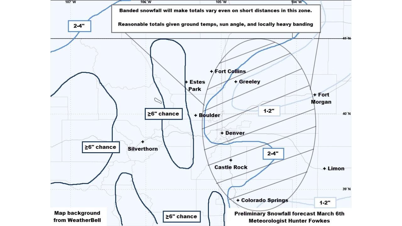
Meteorologists analyzing the latest snowfall projections indicate that totals will vary significantly over short distances due to banded precipitation and relatively warm ground temperatures following several milder days across the region.
Snow Bands Expected to Impact the Front Range Commute
The approaching system is expected to produce periods of moderate to heavy snowfall Friday morning, especially across the urban corridor stretching from northern Colorado into the Denver metro area.
Cities including Fort Collins, Greeley, Boulder, and Denver may see bursts of snowfall strong enough to briefly reduce visibility and make road conditions slick during peak commute hours.
However, because ground temperatures have remained relatively warm in recent days, much of the snowfall may initially melt on roadways and lower-elevation surfaces. Accumulation will be more likely on grassy areas, elevated surfaces, and colder locations outside the immediate city centers.
Meteorologists note that the snow will likely fall in narrow bands, meaning some neighborhoods could see noticeably higher totals than areas just a few miles away.
Snowfall Totals Likely to Vary Across the Region
Forecast maps suggest most of the Front Range corridor will see light to moderate snowfall totals, with slightly higher accumulations possible in localized areas.
Expected snowfall ranges include:
- Denver metro area: generally around 1 to 2 inches
- Castle Rock and southern suburbs: approximately 2 to 4 inches
- Fort Collins and Greeley areas: around 1 to 2 inches
- Colorado Springs and nearby communities: about 1 to 2 inches
Higher terrain locations west of the urban corridor could see locally heavier snowfall, and some mountain areas may have a chance of exceeding 6 inches, especially near regions such as Silverthorne and parts of the high country.
Mountain Areas Could See Higher Snow Totals
While the Front Range cities may experience relatively modest snowfall, higher elevations west of the Interstate 25 corridor are expected to receive more substantial totals.
Areas including Estes Park and mountain communities west of Boulder may see greater accumulation due to colder temperatures and terrain-driven snowfall enhancement.
Meteorologists say some mountain zones could see localized snowfall totals exceeding six inches, especially where snowfall bands persist for longer periods.
Warm Ground Temperatures Could Limit Accumulation
One of the biggest limiting factors for this event is the recent stretch of mild weather across eastern Colorado, which has warmed the ground surface.
Because of this, some of the early snowfall may melt upon contact with pavement, particularly during daylight hours when the sun angle is higher in early March.
Even so, brief periods of heavy snowfall could still allow snow to accumulate quickly, especially on untreated roads, bridges, and elevated surfaces.
Travel Impacts Possible During Morning and Midday Hours
Although the snow event is not expected to be a major winter storm, the timing during the morning and lunchtime commute could still lead to travel slowdowns across the Front Range.
Drivers traveling along Interstate 25, U.S. 36, and surrounding highways near Denver, Boulder, and Fort Collins may encounter slick spots and reduced visibility during heavier snow bursts.
Officials recommend allowing extra travel time and remaining cautious during the periods of heavier snowfall.
Quick-Hitting Snow Event Expected to Move Through Fast
Forecasters emphasize that this will likely be a fast-moving system, meaning snowfall should taper off relatively quickly once the bands pass through the region.
Even so, the combination of heavy wet snow, slushy road conditions, and brief bursts of intense snowfall could still create temporary travel disruptions across parts of Colorado’s Front Range.
Stay with WaldronNews for the latest weather updates and snowfall reports across Colorado as this quick-moving winter system moves through the region.