
Colorado, Idaho, and Utah Could See a Major Snow Boost as Feb. 15–21 “Heavy Snow Risk” Shifts Into the Mountain West
UNITED STATES — After a winter marked by unusually poor snow totals in parts of the Mountain West, a new outlook suggests a snowier pattern may finally arrive Feb. 15–21, with Colorado, Idaho, and Utah among the states highlighted for a meaningful shift toward heavier snowfall potential.
The update points to a “pattern flip” toward West Coast troughing, a setup that can open the door for repeated storm systems to reach the western mountains and, at times, push moisture inland.
What the Feb. 15–21 “Heavy Snow Risk” outlook is signaling
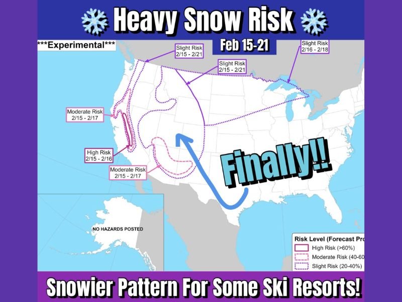
The map shared with this update outlines risk zones for heavy snow during the Feb. 15–21 window and labels it as experimental, meaning it’s designed to flag where the pattern is most supportive of significant snow rather than promise exact totals.
The highest confidence for impactful snowfall potential appears concentrated along parts of the West Coast mountain corridor, where the outlook highlights:
- High risk (Feb. 15–16) in a core West Coast zone
- Moderate risk (Feb. 15–17) expanding around that area
- A broader slight risk (Feb. 15–21) extending inland, which is where portions of the Mountain West get pulled into the “snowier pattern” signal
In plain terms: the atmosphere is leaning toward a storm track that favors the western mountains first, with Colorado/Idaho/Utah positioned to benefit as moisture and colder air work farther inland.
Why Colorado, Idaho, and Utah are being watched closely
The post notes that snow totals in many Western areas have been “lackluster” this season, and that some locations have posted record-low snow numbers, a ripple effect that matters far beyond the slopes.
When mountain snow is scarce for long stretches, the impacts can stack up quickly:
Ski resorts often face reduced terrain, shorter lift operating schedules, and softer booking demand—while nearby towns that rely on winter visitors can feel the slowdown through hotels, restaurants, and seasonal jobs.
This forecast shift is drawing attention because it hints at the kind of multi-day pattern that can rebuild snowpack in stages, especially if storms arrive back-to-back rather than as a single quick hit.
How to read the “risk levels” without overreacting
The key phrase in the graphic is “risk”, not “guarantee.”
A slight risk can still produce meaningful snow in the right terrain, but it also allows for bigger swings based on storm track and timing. Meanwhile, moderate to high risk zones generally reflect stronger agreement that the pattern can support heavier snow rates or repeated rounds.
Because this is an 8–14 day-style outlook window, the most important detail still to be determined is the exact track of each storm, which will decide whether interior mountain areas see consistent snow or more hit-or-miss bursts.
What happens next as the pattern evolves
Over the next several days, shorter-range model runs will clarify:
- Which mountain ranges are best positioned for the heaviest snow
- How far inland Pacific moisture can reach
- Whether colder air locks in long enough to keep precipitation mainly snow
If the west-coast troughing pattern holds, the Mountain West could shift from “waiting for winter” to making up ground quickly—especially at higher elevations.
Want more weather story breakdowns like this as new outlooks and storm tracks develop? Share what you’re seeing in your area and keep following waldronnews.com for ongoing updates.