
Colorado Issues Rare ‘Particularly Dangerous Situation’ Warning for Boulder and Jefferson County Foothills as Extreme Winds Raise Wildfire Risk
COLORADO — The National Weather Service has issued a rare Particularly Dangerous Situation (PDS) alert for Friday across parts of Colorado’s Front Range foothills, warning of extreme wind conditions capable of rapid wildfire spread, especially in and immediately adjacent to Boulder and Jefferson counties.
According to the National Weather Service office in Denver/Boulder, the alert highlights dangerously strong winds combined with very low humidity, creating conditions that could allow any fire ignition to spread rapidly and uncontrollably.
Why the National Weather Service Issued a Particularly Dangerous Situation Alert
The PDS designation is not issued often and is reserved for high-confidence, high-impact events. Forecasters emphasized that Friday’s setup meets that threshold due to a rare overlap of damaging wind speeds, dry air, and vulnerable foothill terrain.
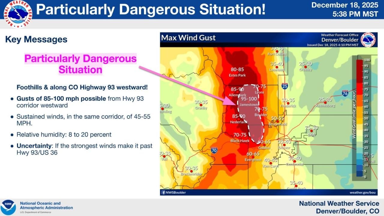
Key conditions outlined by the National Weather Service include:
- Wind gusts of 85 to 100 mph possible
- Sustained winds of 45 to 55 mph
- Relative humidity dropping to 8–20 percent
- Strongest impacts focused along and west of Colorado Highway 93
Forecasters noted uncertainty only in how far east the strongest winds may extend, particularly whether they move beyond Highway 93 and U.S. 36 into more populated areas.
Areas Facing the Greatest Risk
The highest wind potential is forecast across:
- Boulder foothills
- Jefferson County foothills
- Communities and open spaces west of Highway 93
- Wind-prone mountain corridors near Jamestown, Nederland, and surrounding foothill zones
Wind maps included with the alert show core gusts exceeding 90 mph in localized areas, with extreme downslope winds extending toward the Front Range.
Extreme Winds Create Critical Wildfire Conditions
Officials stressed that fire weather concerns are the primary danger, not precipitation or storms. With very dry fuels, even a small ignition could lead to explosive fire growth under Friday’s conditions.
Residents are urged to:
- Avoid any activities that could spark a fire
- Secure loose outdoor items that could become wind-borne
- Prepare for possible power outages
- Stay alert for rapidly changing emergency instructions
Emergency managers emphasize that conditions may deteriorate quickly, leaving little time to react once a fire starts.
Officials Urge Immediate Preparedness
The National Weather Service urged residents in the affected areas to be ready to take swift action if wildfire warnings or evacuation notices are issued.
Because of the forecast wind strength, firefighting efforts could be severely limited, making prevention and early response critical.
What Happens Next
The Particularly Dangerous Situation alert remains focused on Friday, with forecasters continuing to monitor wind trends and humidity levels closely. Any changes in wind direction or strength could significantly alter impact zones.
Residents in Boulder County, Jefferson County, and nearby foothill communities are encouraged to monitor official updates throughout the day and evening.
This is a developing weather and fire safety situation.
For continued updates and local impact coverage, follow WaldronNews.com and stay connected to official National Weather Service alerts.