
Colorado Mountains Slammed With Up to 70 Inches in San Juans While Denver and Boulder End February With Almost No Snow
COLORADO — A dramatic snowfall contrast unfolded across the state over the past five days, with Colorado’s high country piling up feet of snow while Denver and Boulder were left with little more than a trace.
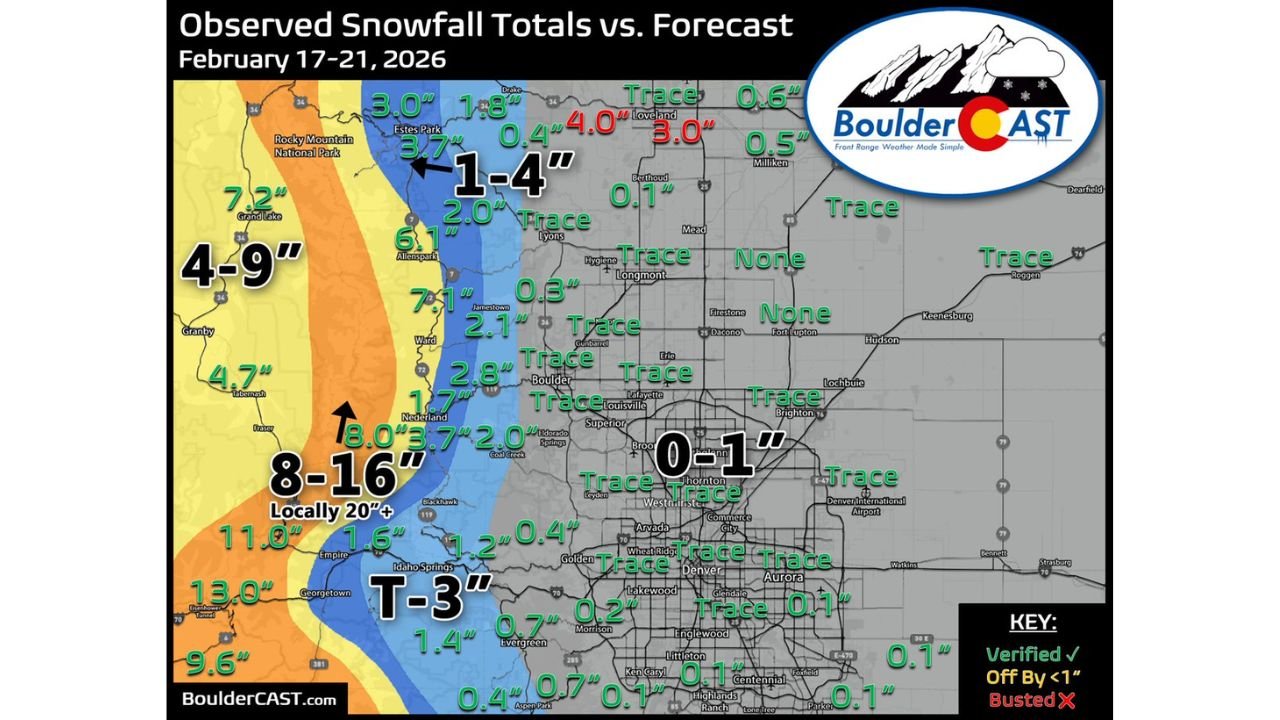
Newly released snowfall data from February 17–21 highlights just how sharply the totals varied between the mountains and the Front Range urban corridor.
San Juan Mountains Lead the State With Feet of Snow
The clear winner of this multi-day storm cycle was the San Juan Mountains in southwestern Colorado, where widespread totals reached 2 to 4 feet.
In fact, snow reports from Wolf Creek Pass indicate as much as 70 inches (5.8 feet) fell during the period — an extraordinary amount even by Colorado standards.
Other mountain areas also saw impressive totals:
- 13.0 inches near Eisenhower Tunnel
- 11.0 inches around Empire
- 9.6 inches near Georgetown
- 7.2 inches around Grand Lake
- 8–16 inches common in higher elevations west of Boulder
- Isolated areas locally topping 20 inches
The west-facing slopes and higher peaks were squarely in the storm’s moisture plume, allowing heavy and consistent snowfall to accumulate over multiple days.
Sharp Drop-Off Along the Front Range
As the storm energy shifted eastward toward lower elevations, snowfall totals dropped dramatically.
Communities along the immediate foothills saw modest accumulations, including:
- 3.7 inches near Estes Park
- 6.1 inches in Allenspark
- 7.1 inches near Ward
- 2.8 inches around Boulder Canyon
- 1.6 inches near Idaho Springs
However, once the system reached the urban corridor, snowfall essentially collapsed.
Denver and Boulder See Only a Trace
Across the Denver metro area, snowfall totals ranged from trace amounts up to 0.1 inch in many neighborhoods.
Observed data shows:
- Numerous “Trace” readings across Denver, Aurora, Lakewood, and Thornton
- 0.1 inches reported in parts of Aurora and Centennial
- No measurable snowfall recorded in some northern suburbs
Boulder fared similarly, picking up only a trace despite heavier snow falling just a few miles west in the foothills.
This means Denver and Boulder remain without measurable snowfall for February — an unusual statistic considering the calendar still sits within peak winter season.
Why the Mountains Won and the Cities Missed
The stark contrast is largely due to elevation and storm track dynamics.
Moisture-laden air rising over the San Juans and other western ranges allowed snow to fall continuously at higher elevations. Meanwhile, downslope flow and slightly warmer boundary layer conditions along the Front Range limited snowfall efficiency once the system crossed into metro Denver.
The result was a classic Colorado setup:
- Feet of snow in the mountains
- Bare ground in the city
Even areas just west of Boulder saw totals in the 1–4 inch range, while downtown locations reported little to nothing.
Observed Totals vs. Forecast
Verification data indicates mountain forecasts generally performed well, with several locations matching projected ranges.
However, parts of the northern Front Range underperformed, with some forecasted light accumulations failing to materialize in Denver and surrounding suburbs.
Looking Ahead
While ski resorts in the San Juans and central mountains benefited significantly from the recent storm cycle, residents along the Front Range are still waiting for a meaningful February snowfall.
For now, the story of this system is one of extremes: feet in the mountains, flakes in the city.
WaldronNews.com will continue tracking Colorado’s winter trends as the season progresses.