
Colorado Snowstorm Watch: Denver, Cheyenne, Fort Collins and Nebraska Panhandle Could See Accumulating Snow Late Thursday Into Friday
DENVER, COLORADO — Forecasters are watching a developing late-week storm that could bring accumulating snowfall to parts of northern Colorado and southern Wyoming, including Denver, Fort Collins, Cheyenne and nearby communities, as colder air moves into the region late Thursday into Friday.
Weather model simulations suggest the system will track far enough north that southern Colorado could see limited impacts, while the northern half of the state may experience the best chance for measurable snow.
Colder Storm Expected to Arrive Late Thursday
Meteorologists indicate the next weather system will push into the region late Thursday night and continue through Friday, bringing colder temperatures compared to recent conditions.
The colder air mass will allow precipitation to fall primarily as snow across higher elevations and northern areas, particularly along and north of the Interstate 70 corridor and into the Front Range.
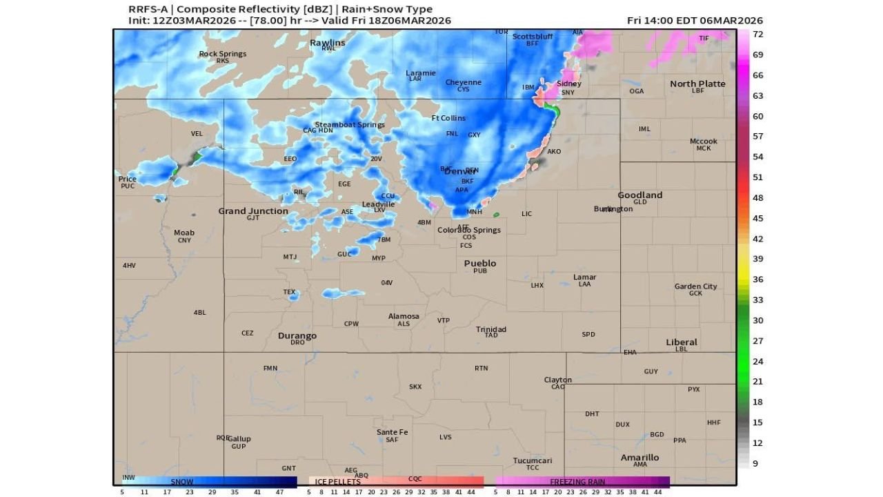
Current projections from the RRFS high-resolution radar simulation model show a wide band of snow developing across:
- Denver metro area
- Fort Collins and northern Front Range
- Cheyenne and southeastern Wyoming
- Parts of the Nebraska Panhandle including Sidney
Snowfall appears most concentrated across north-central Colorado and southern Wyoming, while areas farther south may remain mostly dry if the storm follows a northerly track.
Radar Simulation Shows Northern Colorado Snow Band
The radar simulation snapshot indicates a broad area of snow stretching from the Rocky Mountains through the Front Range into eastern Colorado by Friday afternoon.
Snow coverage appears especially strong near:
- Steamboat Springs
- Laramie and Cheyenne
- Denver and surrounding suburbs
- Sidney, Nebraska
Meanwhile, cities farther south including Pueblo, Trinidad and southern Colorado communities may see little to no snowfall if the system continues trending north.
Forecasters say the storm track will be critical in determining how far south meaningful snowfall extends.
Forecast Still Several Days Away From Final Details
Despite increasing model agreement that a storm will arrive late week, meteorologists emphasize that the system is still roughly 60 hours away from developing, meaning forecast details could change.
Weather experts note that computer models often adjust storm intensity and track during the final days before development, which can significantly impact snowfall totals.
As a result, residents across northern Colorado and southern Wyoming are encouraged to monitor forecast updates throughout the week as the storm approaches.
Additional Snow Chances Possible Next Week
Long-range model guidance also hints at another cold front arriving early next week, potentially bringing additional snow chances across the region between Tuesday and Wednesday.
However, global forecast models remain somewhat inconsistent on the details of that system, indicating uncertainty remains for the extended outlook.
If the colder pattern continues, the region could see a more active stretch of late-season winter weather heading into early March.
Residents planning travel across the Front Range, northern Colorado and southeastern Wyoming later this week should stay aware of forecast updates as the storm develops.
Stay with WaldronNews.com for the latest weather updates, snowfall forecasts, and storm tracking as this late-week Colorado system evolves.