
Connecticut Snowfall Possible This Weekend as Saturday Night Storm Setup Strengthens, Forecast Shows
CONNECTICUT — Evolving Weekend System May Bring Widespread Light Snow Across the State, A developing storm system is showing fresh signs of producing light to moderate snowfall across Connecticut this weekend, with the timing now shifting toward Saturday night into Sunday, according to updated forecast data reviewed Tuesday.
What began as a Friday-night threat has evolved into a later-arriving system as the storm’s timing and track continue to adjust. The latest analysis shows a decent probability for a broad, light snow event — generally in the 1 to 3 inch range, with some pockets potentially reaching 2 to 4 inches depending on the final storm track and available moisture.
Forecast models remain divided:
- The European model is more supportive of a moderate snow event, showing steady snowfall across southern New England.
- The GFS model is more suppressed, keeping heavier snow bands farther south and allowing only weaker snow into the region.
Despite the differences, forecasters believe Connecticut is positioned to receive at least some accumulating snowfall, especially given the cold air already in place.
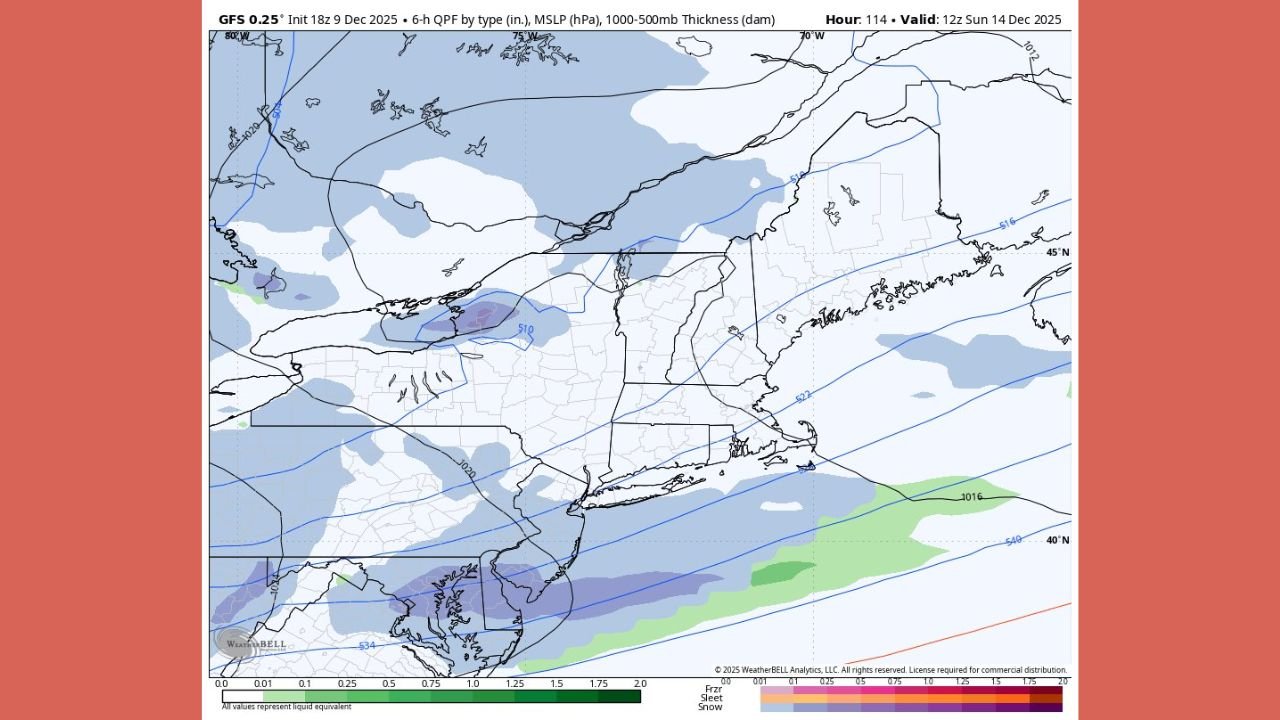
Latest Maps Indicate Strengthening Snow Chances
Several snowfall projections included in the update show the evolving nature of the storm:
European Model (ECMWF)
- Shows a broader shield of snow stretching across Connecticut and Long Island
- Indicates light to steady snow during the day Sunday
- Places a 1–4 inch snowfall zone across much of southern New England
This model currently represents the more snow-friendly scenario.
GFS Model
- Captures the same storm but keeps the primary precipitation band farther south
- Results in lighter totals, primarily under 1–2 inches across Connecticut
- Limits the duration of snowfall
This model reflects a weaker outcome but still supports light accumulation.
Ensemble Snowfall Projections
Data from ensemble members — which help express forecast uncertainty — show:
- Widespread 0.5 to 1.5 inches across much of the state
- Higher totals near the shoreline and eastern Connecticut
- Stronger signals for accumulation where moisture overlaps the coldest air
Even conservative projections still show meaningful potential for snow.
Shoreline Areas May Also See Accumulation
A colder-than-normal air mass is already in place across New England, increasing the likelihood that even southern Connecticut — including shoreline communities — will see flakes stick rather than simply melt on contact.
Forecasters note this as an important factor, since marginal temperatures often make shoreline snow events difficult earlier in December. This weekend’s setup, however, favors accumulation across a wider portion of the state.
How the Setup Is Evolving
Meteorologists analyzing the storm note:
- The system is trending slower, now arriving Saturday night
- Cold air is firmly in place, reducing mixing concerns
- Moisture availability remains the biggest wildcard
- A track slightly farther north or south will determine whether Connecticut lands in a 1–3 inch zone or a more robust 2–4 inch band
Because the system is still several days away, refinements are likely. But confidence is growing that Connecticut will experience at least a light, shovelable snowfall.
What Connecticut Residents Should Expect
If current trends continue, residents should plan for:
- Snow beginning late Saturday or early Sunday
- Light to moderate accumulation
- Slippery roads on Sunday morning
- Minor travel disruptions
- A cold air mass supporting snow for most of the event
Plowable totals are possible in parts of the state, though this does not appear to be a major winter storm.
More Updates Expected as Models Align
The forecast remains sensitive to small shifts in track, and the next 24–48 hours of model updates will help clarify how much snow Connecticut will see. If moisture trends higher or the storm shifts slightly north, totals could increase.
Residents should monitor updates closely as the weekend approaches.
Stay with WaldronNews.com for ongoing updates, snowfall projections, and timing details as the storm draws closer.