
Cross-Country Storm to Slam California, Trigger Severe Weather in Texas and Oklahoma, Then Threaten Snow and Wind from Philadelphia to Maine
UNITED STATES — A powerful cross-country storm system is beginning its journey on the West Coast and is expected to impact multiple regions from California to the Northeast over the coming days, bringing everything from mountain snow to severe thunderstorms and possible coastal snow.
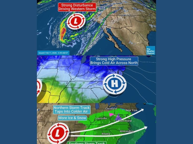
Forecast maps show a strong disturbance pushing into California first, spreading rain and high-elevation snow into the Mountain West, including the Colorado Rockies. But that’s only the beginning.
Phase 1: California and the Mountain West See Rain and Snow
The system currently approaching the West Coast is producing widespread precipitation from California into parts of Nevada, Utah, and Colorado.
Higher elevations of the Colorado Rockies are expected to see snow, while lower elevations receive rain. This marks a notable shift after quieter recent conditions in parts of the West. Forecasters indicate this initial wave is not the main event — a stronger follow-up storm is expected after Valentine’s Day.
Phase 2: Southern Plains Severe Threat Friday Night into Saturday
As the system moves east, energy from the western disturbance is forecast to organize into a developing storm complex across the Southern Plains, particularly:
- Texas
- Oklahoma
- Parts of Kansas and Arkansas
This phase could bring:
- Severe thunderstorms
- Damaging wind gusts
- Heavy rainfall
- A risk of tornadoes
The most active window appears to be Friday night into Saturday, when moisture pulled northward interacts with strengthening low pressure.
Phase 3: Southeast Showers and Thunderstorms Sunday
By Sunday, the storm pushes into the Southeast, spreading showers and embedded thunderstorms across:
- Louisiana
- Mississippi
- Alabama
- Georgia
- Florida
- The Carolinas
While severe weather is possible within this broader system, projections suggest it may not be as widespread or intense as the Plains event.
High pressure building to the north will also introduce colder air across portions of the Mid-Atlantic and interior Southeast.
Phase 4: Potential Northeast Coastal Storm Early Next Week
Beyond the Southeast, forecast models diverge on what happens next.
One model solution indicates an intense low forming along the Northeast coast, potentially bringing:
- Snow
- Rain
- Gusty winds
- Rapid coastal impacts
Areas that could be affected under this scenario include the I-95 corridor, stretching from:
- Philadelphia
- New York City
- Boston
- Up through Downeast Maine
However, an alternative model keeps the storm weaker and farther south, exiting offshore with limited impact.
This remains a key uncertainty heading into early next week.
What This Means
This storm is notable not just for its intensity but for its geographic reach. In less than a week, it is projected to bring:
- Rain and mountain snow in California and Colorado
- Severe storms in Texas and Oklahoma
- Widespread showers in the Southeast
- Possible snow and wind impacts in the Northeast
The situation is still evolving, especially concerning the Northeast coastal development. Stay with WaldronNews.com for continuous updates as this cross-country storm unfolds and regional impacts become clearer over the next several days.