
Crucial Upper-Air Interaction by Thursday Evening May Decide Whether Presidents Day Storm Targets New England or the Mid-Atlantic
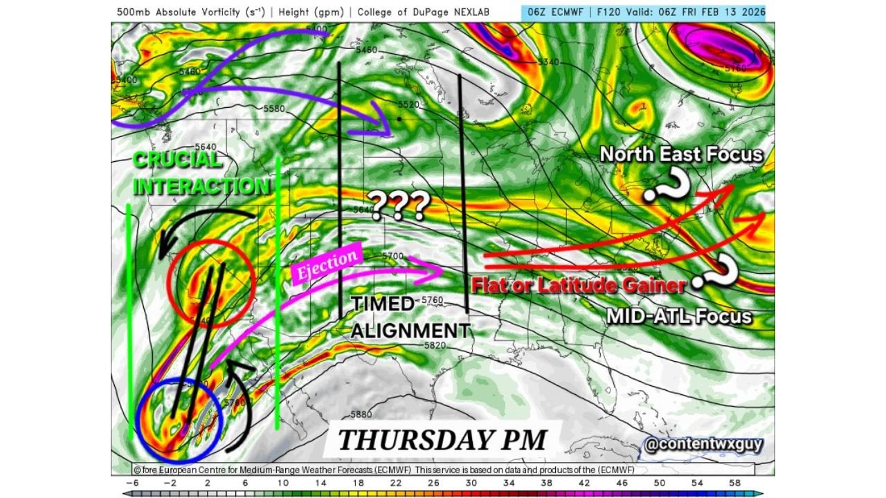
UNITED STATES — New European model guidance highlights a critical upper-level interaction unfolding through Thursday evening, a phase that meteorologists say will ultimately determine where the next significant winter weather threat sets up along the East Coast.
According to the data, forecast confidence drops sharply beyond Thursday night, as small timing differences between key atmospheric features could dramatically alter the storm’s latitude and downstream impacts.
Thursday Evening Marks the End of Reliable Guidance
The image makes it clear: model reliability extends only through Thursday evening. Past that point, solutions begin to vary run-to-run and suite-to-suite, underscoring why this timeframe is being labeled as the decisive window.
This phase is critical because it controls:
- How quickly energy ejects from the western trough
- Whether the flow remains flat or gains latitude
- Where the downstream storm track ultimately locks in
Once this alignment is resolved, confidence in surface impacts will increase rapidly.
Western Trough Interaction Is the Pivotal Trigger
A strong vort max over the Southwest is shown interacting with a second piece of energy lifting northeastward. The diagram labels this zone as a “crucial interaction,” emphasizing how important phasing becomes at this stage.
If the timing is clean and efficient:
- Energy ejects eastward in a more organized fashion
- Downstream flow amplifies
- A more northerly storm track becomes possible
If not, the system remains flatter and slides east with limited latitude gain.
Timed Ejection Determines Storm Latitude
The image highlights a narrow timing corridor, marked by vertical reference lines, where the ejection of energy must align properly with the downstream jet.
- Well-timed ejection supports latitude gain and favors a New England focus
- Poorly timed or delayed ejection keeps the system flatter, shifting focus toward the Mid-Atlantic
This is why the graphic shows uncertainty markers in the central U.S.—that zone determines everything downstream.
Two Distinct Outcomes Still on the Table
The data explicitly shows two competing end-game scenarios:
New England Focus
A more amplified flow allows the system to climb latitude, placing stronger forcing and wintry potential farther north into New England.
Mid-Atlantic Focus
A flatter jet structure limits northward movement, keeping the strongest impacts centered over the Mid-Atlantic with reduced reach into New England.
At this stage, neither solution can be ruled out.
Why Forecasters Are Watching This So Closely
This is a textbook example of how upper-air pattern evolution—not surface lows—controls long-range winter outcomes. Until the interaction phase resolves, surface forecasts will remain volatile.
Once Thursday evening passes and alignment becomes clear, confidence will increase quickly in:
- Storm track
- Wintry precipitation placement
- Regional impact zones
Bottom Line
Thursday evening represents the make-or-break moment for the Presidents Day storm setup. The atmosphere is approaching a fork in the road—one leading toward New England, the other toward the Mid-Atlantic.
WaldronNews.com will continue monitoring model trends closely as this critical interaction approaches and clarity improves.