
D.C. to Boston Snow Chances Climb as Narrow Storm Track Could Bring 3+ Inches — or Leave Cities With Nothing
WASHINGTON, D.C. — A developing Sunday–Monday winter storm remains highly track-dependent, and new probability guidance shows a growing corridor of measurable snow potential stretching from the Mid-Atlantic into southern New England.
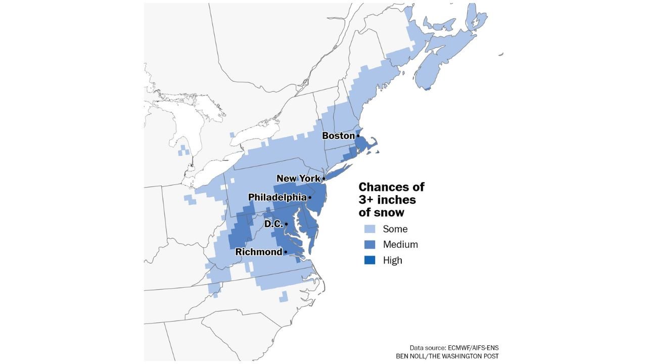
Forecast data now indicates a medium chance of at least 3 inches of snow across parts of Washington, D.C., Philadelphia, New York City, and Boston — but forecasters caution that even a small shift in the storm’s path could dramatically change totals.
A Few Hundred Miles Could Change Everything
The latest ensemble probability map highlights a narrow but significant band of snow potential aligned along the I-95 corridor.
Areas currently showing at least a medium probability of 3+ inches of snowfall include:
- Washington, D.C.
- Richmond, Virginia
- Philadelphia, Pennsylvania
- New York City
- Boston, Massachusetts
Lighter blue shading across portions of interior Pennsylvania, upstate New York, and parts of New England indicates lower but still notable chances for measurable accumulation.
The sharp gradient along the western edge of the snow zone underscores just how sensitive this setup is to storm placement. A slight eastward shift would push heavier snow offshore. A modest westward shift could expand the higher totals inland.
Highest Probabilities Focused Near the Coast
The darkest blue shading — representing the highest probabilities — appears concentrated from:
- Eastern Virginia and the D.C. metro
- Through central and southern New Jersey
- Into portions of New York City and Long Island
- Up toward parts of eastern Massachusetts**
This suggests the coastal corridor currently holds the greatest risk for reaching or exceeding the 3-inch threshold.
Meanwhile, areas farther west across western Pennsylvania and upstate New York show lower confidence in reaching that benchmark.
Sunday Into Monday Timing
The storm is expected to impact the region Sunday into Monday, though exact onset and intensity remain uncertain.
Snowfall rates and totals will depend heavily on:
- The storm’s exact offshore track
- Coastal development strength
- Temperature profiles near the surface
- Upper-level energy alignment
If the storm tracks close enough to the coastline, colder air could lock in and support steady snowfall across major cities. If it remains farther offshore, precipitation may be lighter or miss entirely.
Why Confidence Is Still Moderate — Not High
While probabilities for 3+ inches are increasing, they remain in the “medium” category across much of the corridor.
That means:
- Snow is possible and perhaps likely in some areas.
- A high-end snowstorm is not guaranteed.
- Totals could vary significantly over short distances.
The forecast remains sensitive to relatively small atmospheric changes over the next 24–48 hours.
Cities to Watch Closely
Residents in the following cities should monitor updates closely:
- Richmond
- Washington, D.C.
- Philadelphia
- New York City
- Boston
Travel impacts Sunday afternoon into early Monday are possible if the higher-end scenario verifies.
Bottom Line
A narrow but impactful snow corridor from Washington, D.C. to Boston is emerging in the latest forecast guidance, with medium probabilities for at least 3 inches along the urban Northeast corridor.
However, the margin for error remains small. A track shift of just a few hundred miles could mean the difference between a plowable snowfall and little more than flurries.
WaldronNews.com will continue tracking updated model runs and probability shifts as the Sunday–Monday storm approaches.