
Damaging Winds and Large Hail Threaten Western and Central Pennsylvania Wednesday Afternoon as Cold Front Sparks Scattered Severe Storms
PENNSYLVANIA — Severe weather is once again possible across the state Wednesday afternoon and evening as anomalous warmth and deep moisture combine with strong wind shear ahead of an approaching cold front.
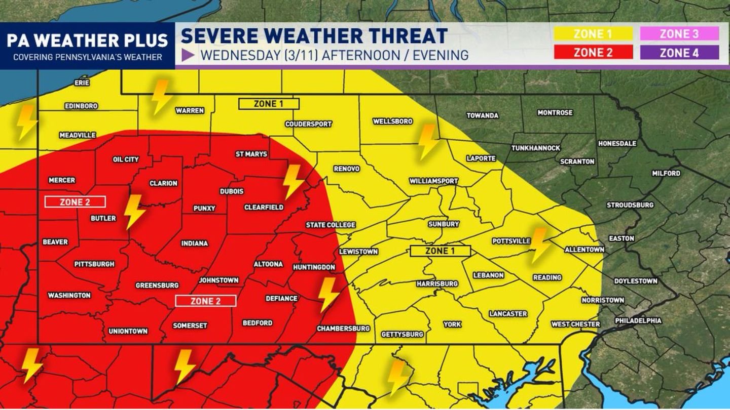
Forecasters are highlighting two primary impact zones across Pennsylvania, with the highest concern centered over western and parts of central counties. While the tornado threat appears isolated, damaging wind gusts and large hail remain the primary hazards.
Setup: Warm, Moist Air Meets Strong Wind Shear
The environment expected Wednesday features:
- Above-normal temperatures
- Increasing low-level moisture
- Strong wind shear with height
Wind shear — the change in wind speed and direction as you move upward through the atmosphere — enhances thunderstorm organization. When combined with sufficient instability, it can allow storms to strengthen quickly and produce severe weather.
A strong incoming cold front will act as the trigger, sparking showers and thunderstorms during the mid-afternoon through early evening hours.
Preliminary Best Timing
The most favorable window for severe development appears to be:
Mid-Afternoon through Early Evening Wednesday, with a few strong storms potentially lingering into the overnight hours.
Storm coverage is not expected to be widespread statewide at the same intensity, but clusters of thunderstorms may develop, including multicell structures, brief line segments, and possibly one or two supercells.
Zone 2: Scattered Strong to Severe Storms (Western & Central PA)
The higher-risk Zone 2 includes much of western Pennsylvania and portions of central counties, including areas near:
- Pittsburgh
- Butler
- Beaver
- Oil City
- Clarion
- Dubois
- Clearfield
- Indiana
- Johnstown
- Greensburg
- Somerset
- Altoona
- State College
- Chambersburg
In this zone, storms may produce:
- Damaging wind gusts
- Large hail
- An isolated tornado
While tornado potential is limited, any discrete storm that briefly rotates could pose a localized risk.
Zone 1: Isolated Strong Storms (Eastern & Northern PA)
Zone 1 covers eastern and parts of northern Pennsylvania, including:
- Harrisburg
- York
- Lancaster
- Lebanon
- Reading
- Allentown
- Williamsport
- Pottsville
In this zone, the threat appears more isolated. Strong to severe storms may still develop, primarily capable of producing damaging wind gusts.
Even non-severe storms could bring:
- Gusty winds
- Frequent lightning
- Heavy downpours
Impacts Will Vary by Location
Forecasters emphasize that severe weather does not impact every neighborhood equally. Impacts can vary significantly over short distances, especially with scattered storm coverage.
Unless storms organize into a larger outbreak scenario — which is not currently indicated — some communities may see strong storms while others experience only rain and thunder.
Preparedness Remains Key
Residents across Pennsylvania should:
- Have multiple ways to receive severe weather alerts
- Monitor radar updates Wednesday afternoon
- Identify a safe location indoors if warnings are issued
Western and central Pennsylvania currently carry the higher risk, but all areas within Zones 1 and 2 should remain alert through the afternoon and evening hours.
WaldronNews.com will continue to monitor developments as Wednesday’s severe weather threat unfolds across the state.