
Damaging Winds, Large Hail, and Isolated Tornadoes Possible Across Ohio Valley as Storms Target Louisville, Cincinnati, Columbus, and Charleston
OHIO VALLEY – A round of severe weather is possible tomorrow afternoon and evening as storms develop west of the region and move eastward, placing several major cities at risk for damaging winds, large hail, and a few tornadoes.
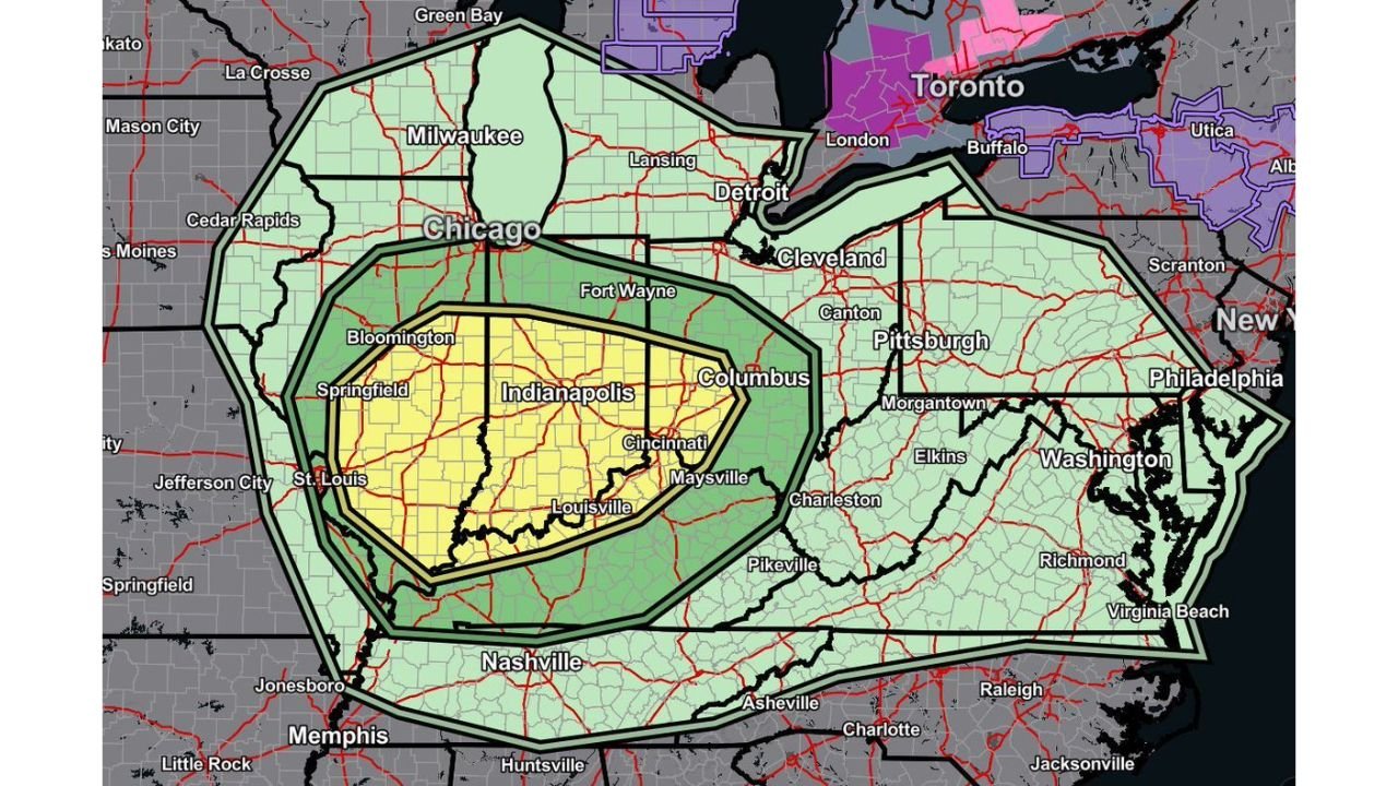
The highlighted threat area stretches from portions of southern Illinois and Indiana eastward through Kentucky, Ohio, and West Virginia, with the greatest concentration of concern centered over Louisville, Lexington, Cincinnati, Indianapolis, Columbus, and Charleston.
Primary Threats: Wind, Hail, and Isolated Tornado Risk
According to the outlined risk zones shown on the map:
- Damaging straight-line winds appear to be the most widespread concern
- Large hail is possible with stronger discrete cells
- A few tornadoes cannot be ruled out, especially in the core highlighted area
The yellow-shaded region, covering much of central and southern Indiana and northern Kentucky into southwest Ohio, represents the higher-end risk zone within the broader outlook.
Cities Most Directly in the Core Zone
The highest threat area includes:
- Indianapolis, IN
- Louisville, KY
- Cincinnati, OH
- Columbus, OH
- Surrounding communities across southern Indiana and northern Kentucky
Storms are expected to move west to east, meaning communities in Illinois and Indiana may see activity first, with storms then progressing into Ohio and West Virginia by late afternoon or early evening.
Broader Risk Extends to Chicago, Pittsburgh, and Charleston
A larger green-shaded area surrounds the higher threat zone and includes:
- Chicago, IL
- Fort Wayne, IN
- Cleveland, OH
- Pittsburgh, PA
- Charleston, WV
- Portions of western Pennsylvania and northern Kentucky
While the severe threat may be more isolated in these outer areas, damaging wind gusts and hail remain possible if storms maintain strength.
Timing: Afternoon Through Early Evening
The most active period appears to be:
- Mid-afternoon through early evening
- Storms initiating west of the Ohio River Valley
- Progressing steadily eastward into Ohio and West Virginia
As with most severe setups, storm intensity and coverage will depend on daytime heating and how quickly instability builds ahead of the system.
Residents Should Be Ready to Act
Because damaging winds and isolated tornadoes are possible:
- Have multiple ways to receive weather warnings
- Keep mobile alerts enabled
- Review your shelter plan in advance
- Avoid waiting until a warning is issued to prepare
Severe weather outlooks can be refined overnight as higher-resolution models lock in timing and storm mode, so forecast details may shift slightly by morning.
Bottom Line for the Ohio Valley
A well-defined severe weather zone is in place for tomorrow, with the most significant risk centered on Indiana, northern Kentucky, and southwest Ohio. Louisville, Cincinnati, Columbus, and Indianapolis are in the heart of the highlighted region.
Storms are expected to move west to east, bringing the potential for damaging winds, hail, and isolated tornadoes during the afternoon and evening hours.
Stay weather-aware and continue checking for updated guidance as the system approaches.
For continuing severe weather coverage across the Ohio Valley and Midwest, follow updates on WaldronNews.com.