
Dangerous Arctic Air Targets New York, New Jersey, and Connecticut as Wind Chills Plunge Well Below Zero This Weekend
UNITED STATES — Another dangerously cold Arctic air mass is forecast to surge into the Northeast this weekend, bringing brutal wind chills well below zero across New York, New Jersey, and Connecticut, according to newly issued National Weather Service wind chill maps. Strong winds combined with plunging temperatures will create life-threatening cold exposure conditions from Friday night through Sunday night.
Meteorologists warn that this will be one of the coldest air intrusions of the winter, with the most severe impacts expected during overnight and early morning hours.
Bitter Cold Arrives Friday Night Across the Tri-State Area
By Friday evening, cold air will already be firmly in place across the region. Forecast wind chill maps show apparent temperatures near or below zero across much of northern New Jersey, the Hudson Valley, and interior Connecticut.
- Wind chills around 0°F to -5°F are expected near New York City, Newark, and coastal Long Island
- Interior locations such as Poughkeepsie, Danbury, and Middletown may dip to -5°F or colder
- Gusty northwest winds will continue overnight, preventing temperatures from stabilizing
Even coastal areas, which often stay milder, will not escape the cold due to persistent winds off the Atlantic.
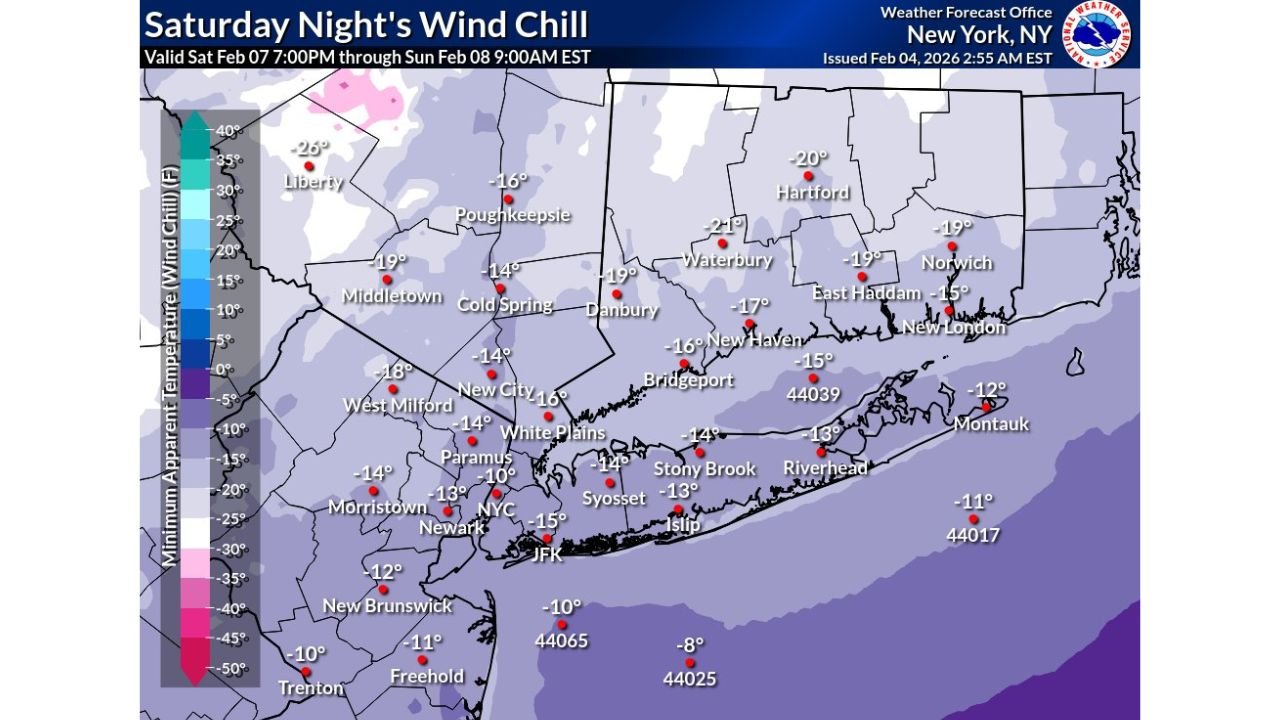
Saturday Night Brings the Coldest Conditions of the Event
The most dangerous cold is expected Saturday night into early Sunday morning, when the core of the Arctic air mass settles over the region.
Forecast data shows:
- Wind chills of -10°F to -20°F across interior New York and Connecticut
- -15°F or colder possible in parts of the Hudson Valley and western Connecticut
- Urban areas including New York City, Newark, and Bridgeport falling into the -10°F range
- Long Island locations such as Stony Brook, Riverhead, and Montauk experiencing sub-zero wind chills, despite proximity to the ocean
These values are well below typical early-February normals and pose a serious risk for frostbite on exposed skin in as little as 20–30 minutes.
Slight Improvement Sunday Night, But Cold Remains Dangerous
Conditions will remain harsh Sunday night, though some moderation is expected compared to Saturday night.
- Wind chills generally between -5°F and -15°F
- Interior zones still colder than coastal locations
- Winds remain strong enough to keep apparent temperatures dangerously low
While temperatures may slowly begin to recover early next week, forecasters stress that cold stress risks will persist through the weekend, especially during nighttime hours.
Strong Winds Amplify the Cold Threat
This event is not just about low temperatures. Strong winds are the primary driver of the danger, stripping heat from the body far faster than calm conditions.
- Gusts will remain elevated through Saturday and Sunday
- Wind exposure will significantly worsen conditions on bridges, open highways, and elevated terrain
- Power infrastructure and outdoor equipment may also be strained by the prolonged cold
Residents in high-rise buildings and open suburban areas are likely to feel the effects more intensely.
Safety Concerns and What Residents Should Know
With wind chills this low, weather officials urge residents across New York, New Jersey, and Connecticut to take the cold seriously.
Key concerns include:
- Frostbite and hypothermia risk
- Strain on heating systems
- Dangerous conditions for anyone outdoors for extended periods
- Increased risk for pets and livestock
Outdoor exposure should be limited as much as possible, particularly overnight and during early morning hours.
Cold Pattern Continues an Unforgiving Winter Stretch
This Arctic outbreak follows a winter already marked by repeated cold surges, reinforcing a pattern of below-normal temperatures across much of the eastern United States.
While gradual moderation is expected after the weekend, meteorologists caution that winter is far from over, and additional cold shots remain possible later this month.
WaldronNews.com will continue monitoring temperature trends, wind chill advisories, and any potential warnings issued as this dangerous cold event unfolds. Stay with us for further updates as conditions evolve.