
Dangerous Damaging Wind Threat Wednesday Across Alabama Tennessee Kentucky West Virginia Ohio Pennsylvania Maryland Virginia and New York As StormNet Signals Powerful Squall Line
PENNSYLVANIA — A potentially dangerous severe weather event is drawing growing concern across the eastern United States as meteorological guidance signals an unusually strong damaging wind setup expected Wednesday from Alabama and Tennessee through Kentucky, West Virginia, Ohio, Pennsylvania, Maryland, Virginia and New York.
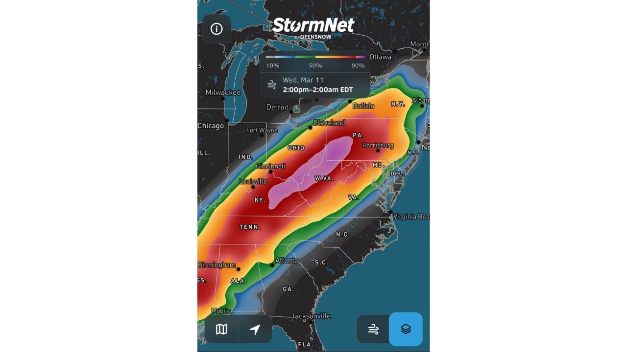
Storm prediction data from the StormNet v4 system indicates a powerful corridor of severe wind potential stretching across the Ohio Valley, Central Appalachians and Mid-Atlantic, with the threat window expected between 2:00 PM Wednesday and 2:00 AM Thursday (EDT).
The forecast highlights a large swath of elevated probabilities for damaging winds, suggesting that storms could organize into a long-track squall line capable of producing widespread wind damage across multiple states.
Severe Weather Corridor Extends from Alabama to New York
The developing system is projected to impact a long north-east oriented corridor beginning in southern Alabama and Tennessee, extending through Kentucky and West Virginia, and continuing into Ohio, Pennsylvania, Maryland, Virginia and New York.
Cities and regions within or near the projected corridor include:
- Mobile, Alabama
- Birmingham, Alabama
- Nashville and central Tennessee
- Louisville and western Kentucky
- Cincinnati, Ohio
- Charleston, West Virginia
- Harrisburg, Pennsylvania
- Cleveland, Ohio
- Buffalo, New York
Meteorologists say this setup resembles a classic spring squall line event, where a long line of thunderstorms develops and moves rapidly across several states while producing intense straight-line wind gusts.
Central Appalachians Could See the Strongest Wind Potential
Forecast probability maps show the highest concentration of damaging wind potential centered over Kentucky, West Virginia, Ohio and Pennsylvania, where the strongest storm dynamics could align Wednesday evening.
Within this core region, thunderstorms could generate:
- Widespread damaging wind gusts
- Power outages caused by downed trees and power lines
- Isolated tornadoes embedded within the squall line
The storm system is expected to track northeast through the Ohio Valley during the afternoon, before pushing into the Appalachians and Mid-Atlantic during the evening and overnight hours.
Timing Window Points to Afternoon and Overnight Impacts
Current projections indicate the severe weather window beginning during the mid-afternoon Wednesday across Tennessee, Alabama and Kentucky, then expanding northeast into West Virginia, Ohio and Pennsylvania during the evening.
Later in the night, storms could continue moving into Maryland, Virginia and parts of New York, with the severe wind threat potentially continuing into the overnight hours.
Because the system may organize into a fast-moving squall line, damaging wind gusts could spread across a wide region quickly once storms begin to intensify.
Strong Atmospheric Setup Driving the Severe Risk
Meteorologists monitoring the pattern say the environment supporting Wednesday’s storms appears unusually favorable for damaging wind production.
A strong upper-level weather system moving across the country is expected to interact with warm and moist air ahead of the storm line, creating the atmospheric energy needed for organized severe thunderstorms.
When these ingredients combine with strong wind fields in the upper atmosphere, storms can rapidly organize into large, fast-moving lines capable of producing widespread wind damage.
Residents Across Multiple States Should Monitor Forecasts
Although the exact placement of the strongest storms may shift as the event approaches, forecasters emphasize that large portions of Alabama, Tennessee, Kentucky, West Virginia, Ohio, Pennsylvania, Maryland, Virginia and New York should remain weather aware heading into Wednesday.
Residents are encouraged to stay updated on forecast changes and ensure they have multiple ways to receive severe weather warnings, particularly during the evening and overnight hours when storms could become more intense.
Stay with WaldronNews.com for continuing updates as meteorologists track this developing severe weather threat expected to move across the eastern United States Wednesday.