
Dangerous Heat and Powerful Wind Gusts to Grip Los Angeles and Southern California This Weekend — Temperatures Running 10 to 20 Degrees Above Normal
LOS ANGELES, CALIFORNIA — A significant late-March heat event is unfolding across Southern California this weekend, with temperatures expected to run 10 to 20 degrees above normal from Friday through Sunday, March 27–29, 2026. The National Weather Service Los Angeles/Oxnard office is forecasting dangerously warm conditions across inland valleys, mountains, and desert communities — with Saturday shaping up as the single warmest day of the stretch. Alongside the heat, southwest winds gusting 25 to 40 mph across the mountains and deserts are adding to the hazard picture for millions of residents across the region.
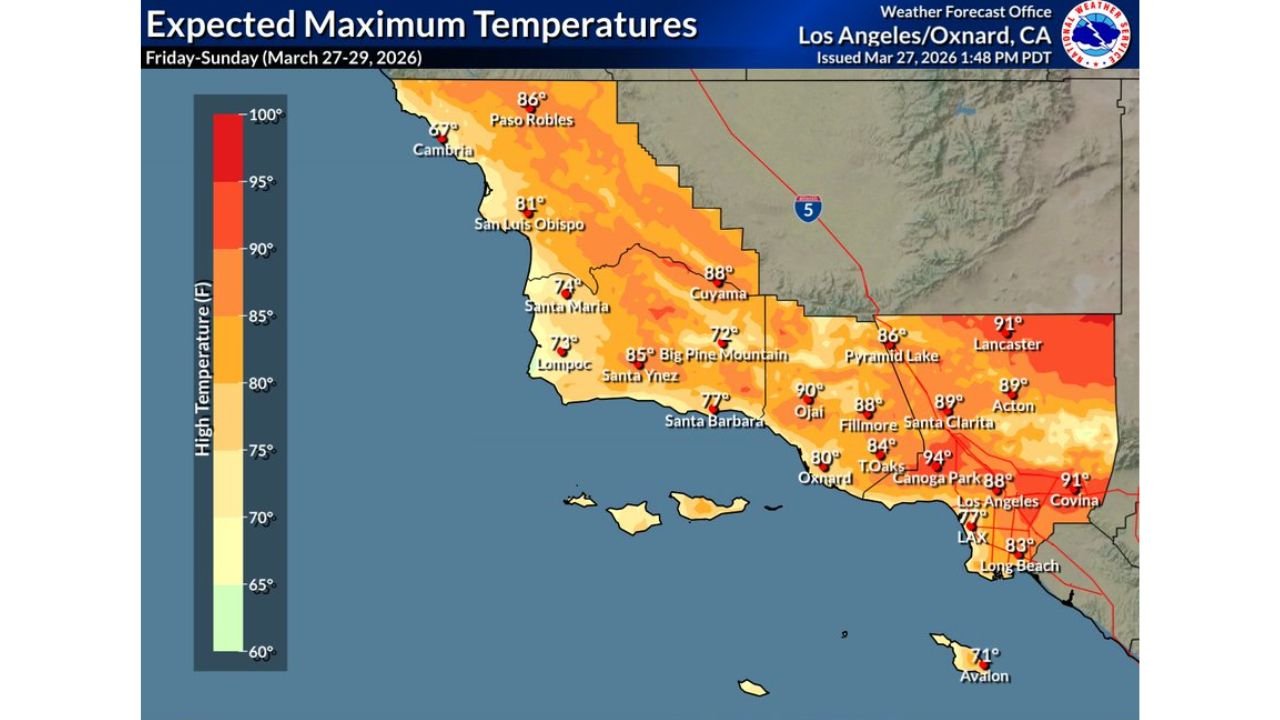
Cities and Areas in the Heat and Wind Zone
The NWS Los Angeles/Oxnard forecast shows extreme maximum temperatures and significant wind gusts across a wide corridor of Southern California:
- Los Angeles: Highs near 88°F, wind gusts to 14 mph
- Lancaster: Highs up to 91°F, gusts reaching 25 mph
- Canoga Park: Blazing 94°F expected — among the hottest readings in the region
- Santa Clarita: Highs near 89°F, gusts to 15 mph
- Acton: Highs of 89°F with significant gusts up to 26 mph
- Covina: Highs reaching 91°F, gusts to 15 mph
- Ojai: Highs of 90°F with relatively lighter gusts near 9 mph
- Fillmore: Highs near 88°F, gusts to 17 mph
- Thousand Oaks: Highs around 84°F, gusts to 18 mph
- Oxnard: Highs of 80°F, gusts near 16 mph
- Santa Barbara: Highs of 77°F, gusts to 12 mph
- San Luis Obispo: Highs of 81°F, gusts to 21 mph
- Santa Maria: Highs near 74°F with gusts to 24 mph
- Paso Robles: Highs of 86°F, gusts to 13 mph
- Long Beach: Highs of 83°F, gusts near 14 mph
- LAX / Coastal Los Angeles: Highs of 77°F — cooler marine layer keeping the coast more comfortable
Primary Threats This Weekend
The NWS Los Angeles office and forecast data are highlighting several key hazards across Southern California:
- Temperatures 10 to 20 degrees above normal for late March across inland and valley areas
- Minor risk for heat-related illness — particularly for outdoor workers, elderly residents, and those without air conditioning
- SW wind gusts of 25 to 40 mph across the mountains and deserts
- Fire weather concerns — the combination of heat, low humidity, and gusty winds creates elevated fire weather conditions across vulnerable terrain
- Saturday the warmest day — the peak of the heat event before any gradual moderation Sunday
Why This Heat Event Stands Out for the Los Angeles Region
For late March, temperatures in the 88°F to 94°F range across the Los Angeles basin and inland valleys are strikingly anomalous. The typical high for Los Angeles in late March sits closer to the mid-60s, meaning communities like Canoga Park at 94°F and Lancaster and Covina at 91°F are running nearly 25 to 30 degrees above climatological norms for this time of year.
The mountain and desert communities face a compounded threat. SW winds gusting to 40 mph combined with extreme heat and low relative humidity create the kind of conditions that fire weather forecasters take very seriously across Los Angeles, Ventura and San Luis Obispo counties. Residents near wildland-urban interface areas should remain especially alert this weekend.
Multi-Day Pattern: Heat Peaks Saturday Before Gradual Easing
Saturday, March 28 is forecast to be the warmest day of the weekend across Southern California, with Sunday expected to bring a very modest easing in temperatures as the overall pattern begins a slow shift. However, the moderation will be gradual — Sunday will still be well above normal across most of the region, and wind gusts may persist through the day across the mountains and high desert communities including Lancaster and Acton.
There is no significant cooling event on the immediate horizon for Los Angeles and Southern California, meaning residents should plan for an extended stretch of above-normal warmth heading into the final days of March.
What to Watch Next
As the weekend develops, key items to monitor include:
- Saturday peak temperatures across inland valleys and the Los Angeles basin
- Wind gust intensity across mountains and deserts — particularly near Lancaster, Acton and Pyramid Lake
- Fire weather watches or warnings that may be issued for vulnerable terrain
- Heat-related illness reports from outdoor events and vulnerable communities
- Sunday temperature trends and whether cooling arrives faster or slower than currently forecast
Residents across Los Angeles, Ventura, Santa Barbara and San Luis Obispo counties should limit strenuous outdoor activity during the hottest afternoon hours, stay hydrated, and check on elderly neighbors and family members this weekend.
WaldronNews.com will continue monitoring this heat and wind event and provide updated information as the weekend forecast evolves.