
Dangerous Ice and Extreme Cold Grip North Carolina and South Carolina Tonight, Making Travel Highly Discouraged as Roads Flash-Freeze After Sunset
SOUTH CAROLINA — Dangerous travel conditions are rapidly developing across large portions of western and central North Carolina and upstate South Carolina tonight as temperatures plunge well below freezing, strong winds continue, and any remaining wet or slushy roads freeze solid shortly after sunset.
Weather officials are urging residents to avoid unnecessary travel, warning that conditions will deteriorate quickly through the evening hours as daylight fades and surface temperatures continue to fall.
Flash-Freezing Roads Creating Major Travel Hazards
With sunset approaching, road conditions are expected to worsen rapidly, even in areas where roads appeared merely wet earlier in the day.
Forecasters warn that:
- Any slush or standing water will freeze quickly
- Bridges and overpasses will ice first
- Rural and untreated roads will become extremely slick
- Visibility may be reduced at times due to blowing snow in higher elevations
Once ice forms, road crews will have limited ability to improve conditions overnight due to persistently cold temperatures.
Bitter Cold and Strong Winds Add to the Danger
Temperature forecasts show single-digit lows and teens across much of the region, with mountain areas dropping to near or below 0°F.
At the same time, gusty winds of 30 to 45 mph, especially along the Blue Ridge and foothills, are driving dangerous wind chills:
- Wind chills of −10°F to −20°F in mountain locations
- Single-digit or below-zero wind chills spreading into foothills
- Prolonged exposure could lead to frostbite in as little as 30 minutes
The combination of ice-covered roads and extreme cold significantly increases the risk of vehicle accidents, breakdowns, and exposure emergencies.
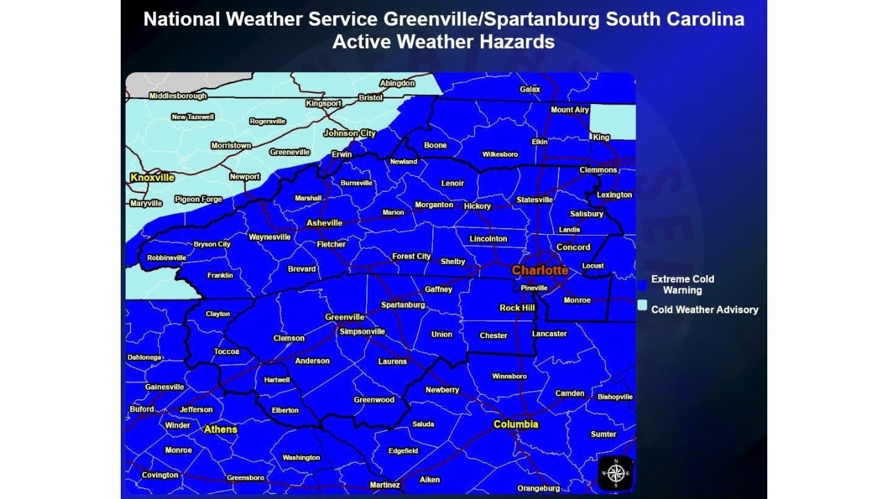
Extreme Cold Warnings and Advisories Remain in Effect
Much of North Carolina and South Carolina remains under Extreme Cold Warnings or Cold Weather Advisories, reflecting the seriousness of the situation.
These alerts highlight:
- Elevated risk to anyone stranded outdoors
- Increased likelihood of frozen pipes
- Danger to pets, livestock, and vulnerable populations
- Additional strain on power and heating systems
Officials stress that this is not a typical cold night for the Carolinas, but rather a high-impact Arctic event.
What Residents Should Do Tonight
Emergency managers and weather officials strongly recommend:
- Avoiding travel after dark unless absolutely necessary
- Carrying emergency supplies if travel cannot be avoided
- Keeping pets indoors and livestock protected
- Checking on elderly neighbors and those without reliable heat
- Allowing faucets to drip to reduce pipe freezing
Even short trips can become dangerous if a vehicle slides off the road or stalls in sub-zero wind chills.
When Conditions May Improve
Temperatures are expected to remain dangerously cold through the night, with only gradual improvement possible during the day Sunday. However, any ice that forms tonight may linger well into Sunday, especially in shaded and higher-elevation areas.
For now, officials emphasize one clear message: tonight is not the night to be on the roads.
Are conditions already icy where you live? Share what you’re seeing locally and stay with WaldronNews for continued updates on dangerous winter weather across North Carolina and South Carolina.