
Dangerous Ice Storm Targets Pennsylvania With Freezing Rain, Hazardous Travel on I-80, and Power Outage Risk Friday
PENNSYLVANIA — A high-impact ice storm is set to affect large portions of the state on Friday, with freezing rain expected to create hazardous travel conditions, especially within the Ice Storm Warning area and along major corridors such as Interstate 80. Forecasters warn that even small amounts of ice can make roads treacherous, while heavier accretion raises the risk of downed trees and power outages.
The greatest concern centers on northwestern and north-central Pennsylvania, where confidence is highest that freezing rain will persist long enough to produce meaningful ice buildup before warmer air arrives.
Freezing Rain Impacts Depend on Warm Air Timing
Meteorologists emphasize that how quickly warm air advances aloft will determine the severity and duration of freezing rain. If the warm layer arrives sooner, ice totals may be lower; a slower warm-air advance would allow ice to accumulate longer, increasing impacts.
Regardless of totals, officials stress that any ice accumulation is dangerous, particularly during the morning and evening travel windows.
Most Significant Ice Northeast of Pittsburgh
Forecast guidance indicates the most impactful ice accretion northeast of Pittsburgh, where prolonged freezing rain is most likely. In and around the Pittsburgh metro, a brief glaze at onset may still make roads slick before precipitation transitions to rain.
Areas farther northeast are expected to remain cold at the surface longer, allowing greater ice buildup on roads, bridges, trees, and power lines.
Ice Accumulation Amounts and Uncertainty Zone
Event-total ice maps show widespread glaze with locally higher amounts possible in favored corridors. A corridor of greatest uncertainty runs through parts of western Pennsylvania, where small temperature changes could swing outcomes between lighter icing and more damaging accretion.
Residents should be prepared for conditions to change quickly over short distances.
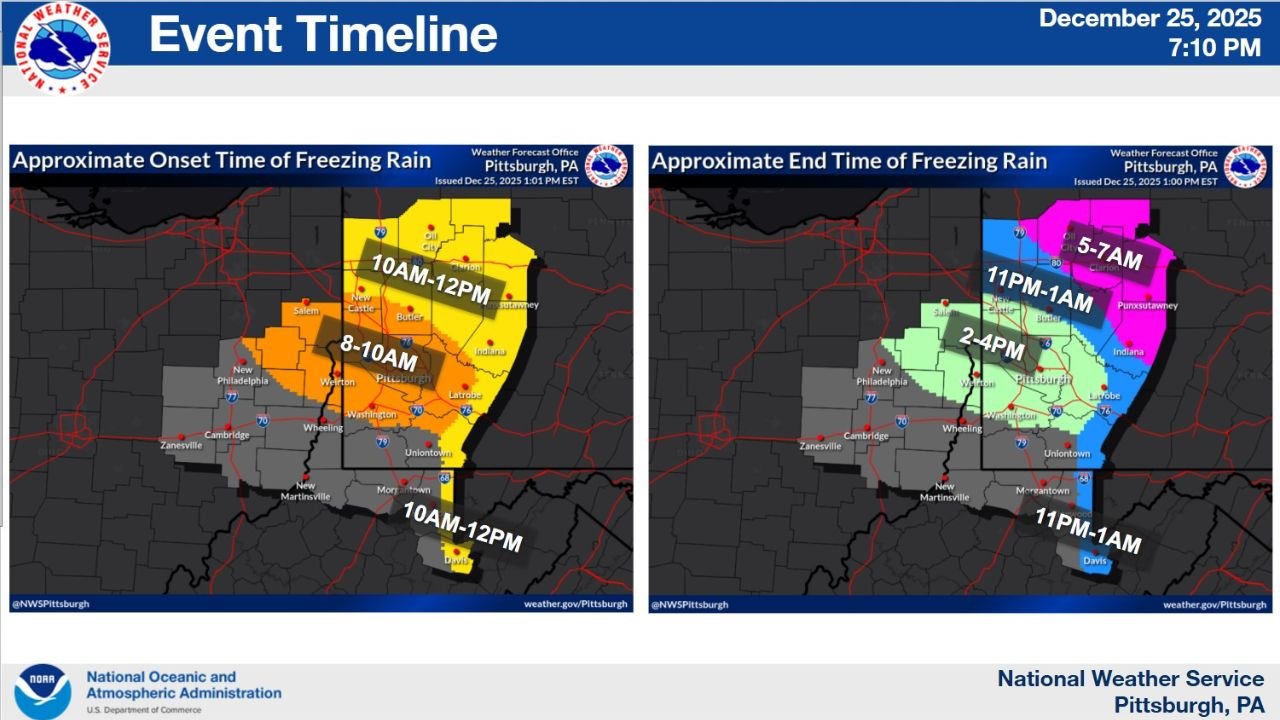
Timeline: When Freezing Rain Begins and Ends
- Onset: Freezing rain develops early Friday, spreading northeast through the morning.
- Peak impacts: Late morning through afternoon in the hardest-hit areas.
- End: Gradual improvement Friday evening into the overnight, though icy surfaces may linger well after precipitation ends.
Travel conditions may remain hazardous even after icing tapers, especially on bridges, overpasses, and untreated roads.
Travel and Power Outage Concerns
- Travel: Avoid unnecessary driving in warned areas; I-80 travel is strongly discouraged during icing.
- Power: Ice on trees and lines may cause scattered to localized outages.
- Safety: Prepare for possible outages, keep devices charged, and check on vulnerable neighbors.
Bottom Line
A dangerous freezing rain event will impact Pennsylvania on Friday, with hazardous travel—particularly on I-80—and a risk for power outages in areas that see prolonged icing. Because any ice is dangerous, residents should finalize preparations, limit travel, and monitor updates closely.
WaldronNews.com will continue to provide updates as new guidance and advisories are issued.