
Dangerous Severe Weather Outbreak Possible Friday From Dallas to Chicago as Enhanced Risk and Strong Tornado Potential Emerges Across the Plains and Midwest
UNITED STATES — Meteorologists are warning of a potentially dangerous severe weather outbreak on Friday, March 6, as a powerful storm system is forecast to sweep across the Southern Plains into the Midwest, creating conditions favorable for large hail, destructive winds, and strong tornadoes.
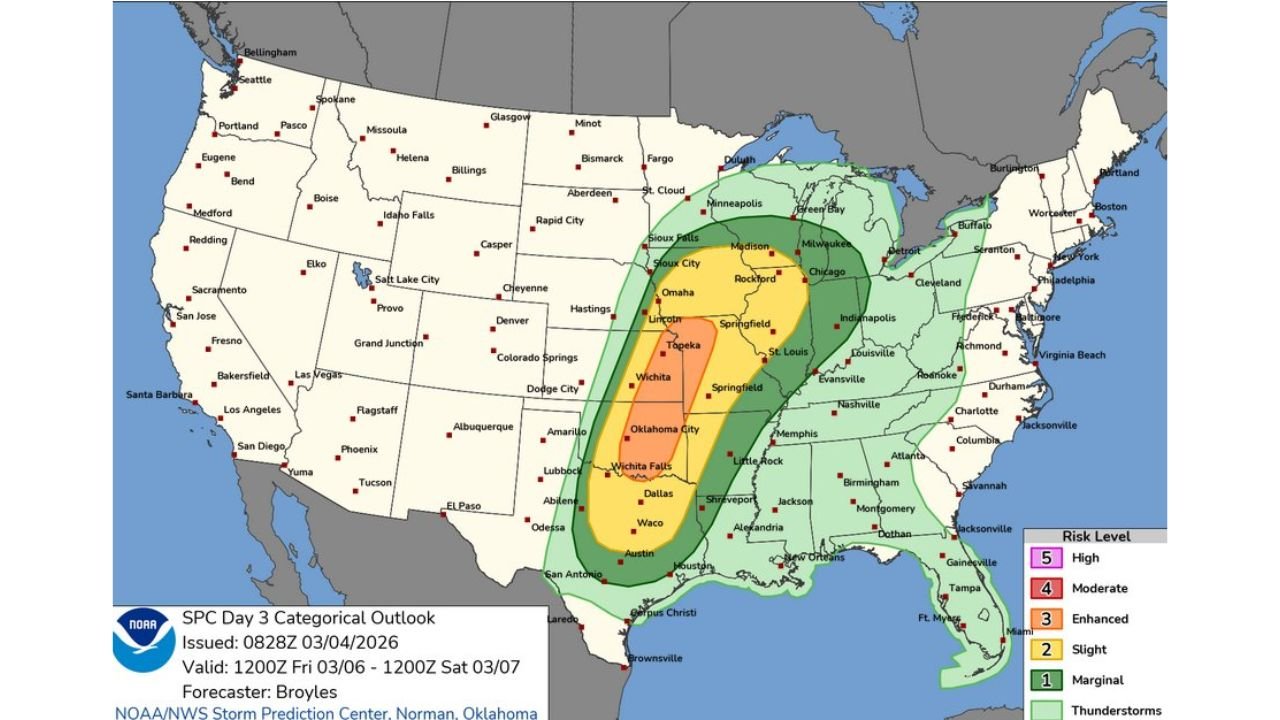
Forecast maps from the National Weather Service Storm Prediction Center (SPC) show a broad corridor of severe weather risk extending from central Texas through Oklahoma, Kansas, Missouri, Illinois, and into parts of Wisconsin and the Great Lakes region.
The system is expected to intensify during the afternoon and evening hours as atmospheric conditions align for organized thunderstorms.
Enhanced Risk Area Spans the Southern and Central Plains
The latest outlook places an Enhanced Risk (Level 3 of 5) across a large portion of the Southern and Central Plains into the lower to mid-Missouri Valley.
Cities within or near the higher risk zone include:
- Dallas and Waco, Texas
- Oklahoma City, Oklahoma
- Wichita and Topeka, Kansas
- Springfield and St. Louis, Missouri
- Rockford and Chicago, Illinois
- Madison and Milwaukee, Wisconsin
A broader Slight Risk (Level 2) surrounds this area and stretches farther south toward Austin and San Antonio, and northeast into the Great Lakes region.
Strong Upper-Level Jet Stream Driving Storm Development
Meteorologists say a strong upper-level trough moving eastward across the central High Plains will provide the large-scale energy needed to initiate storms.
Forecast data indicates a 65 to 85 knot mid-level jet stream will sweep across the region during the afternoon. These strong winds aloft will create moderate to strong wind shear, a key ingredient for severe thunderstorms.
Wind shear helps storms organize and rotate, increasing the risk of supercell thunderstorms capable of producing tornadoes.
Warm, Moist Air Fueling Instability
Ahead of the advancing cold front, warm air and moisture from the Gulf of Mexico will surge northward into the Plains and Midwest.
Surface dew points are forecast to reach the lower to mid-60s°F, creating a moist and unstable atmosphere.
By midday, moderate atmospheric instability is expected to develop across much of the region, providing fuel for thunderstorms once they begin forming.
Storms Likely to Develop Late Afternoon
Forecasters expect thunderstorm development to begin during the mid to late afternoon across the southern and central Plains, particularly along a strengthening frontal boundary.
Storms will likely track north-northeast from Texas and Oklahoma into Kansas, Missouri, and Illinois during the evening hours.
As storms intensify, they may initially form as discrete supercells before gradually merging into clusters or lines later in the night.
Strong Tornadoes, Large Hail, and Damaging Winds Possible
The severe weather threats across the region include:
- Strong tornadoes
- Very large hail (potentially larger than 2 inches)
- Damaging wind gusts
Meteorologists note that the combination of strong wind shear, moisture, and instability may support supercell storms capable of producing significant tornadoes, particularly across parts of Texas, Oklahoma, and Kansas.
The severe weather threat may continue into the evening and overnight hours as storms move into the Missouri Valley and Midwest.
Storms May Evolve Into Large Storm Clusters Overnight
As the system progresses into the night, individual supercells may merge into larger storm clusters or a severe line of storms.
This transition could expand the threat of widespread damaging winds across Missouri, Illinois, and neighboring states.
Communities across the Mid-Mississippi Valley and lower Missouri Valley should prepare for the possibility of strong storms continuing overnight.
WaldronNews Monitoring Potential Outbreak
Forecasters emphasize that Friday’s severe weather setup is still evolving, and small changes in storm timing or track could shift the areas most at risk.
Residents across Texas, Oklahoma, Kansas, Missouri, Illinois, and Wisconsin are encouraged to stay informed and review severe weather safety plans.
WaldronNews will continue monitoring this developing weather situation, providing updated forecasts and severe weather alerts as the storm system approaches.
Stay connected with WaldronNews.com for the latest coverage and real-time weather updates as this potentially significant storm outbreak develops.