
Daytona 500 Weather Watch: Fast-Moving Line of Rain Targets Florida Sunday Evening as Models Debate Timing Around 3PM Green Flag
FLORIDA — All eyes are on the radar this Sunday as a fast-moving line of rain threatens to move into central and northeast Florida later in the day — right as fans prepare for the Daytona 500.
Forecast models show a band of showers and embedded thunderstorms sweeping east across the Southeast, with the main concern centered on how quickly the rain reaches the Daytona Beach area.
The green flag is scheduled for around 3:00 PM, and the race typically runs approximately 3.5 hours, placing the potential finish window near early evening — right when some model guidance suggests the heaviest rain could approach.
Model Guidance Points to Late-Day Line
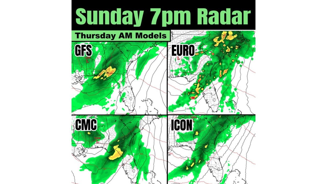
Thursday morning model runs from the GFS, EURO, CMC, and ICON all show a defined rain band progressing from the eastern Gulf Coast into northern and central Florida by Sunday evening.
Key takeaways from model consensus:
- A main line of showers and storms moves west to east.
- Heavier precipitation is focused along a narrow corridor.
- The system appears progressive and fast-moving.
- Rain totals are generally projected to remain under one inch due to forward speed.
The EURO model has trended slightly slower compared to earlier runs — a development that may be favorable for race timing if the bulk of rainfall holds off until later in the evening.
Question Mark: Spotty Showers Before the Main Line
While the primary band of rain looks organized and relatively fast-moving, some model solutions suggest the possibility of lighter, scattered showers ahead of the main line during the afternoon.
This is tied to a coastal Atlantic flow setup that sometimes produces hit-or-miss showers before the main frontal boundary arrives.
Those lighter showers are less certain and could determine whether the race begins on time or sees minor delays.
Timing Is Everything for Daytona Beach
The biggest factor for Daytona International Speedway will be:
- Whether the main rain band arrives before 6–7 PM
- Or whether it holds off until after the bulk of the race is completed
If the line maintains a faster progression, rain could move through relatively quickly, limiting total accumulation and reducing prolonged delays.
If the system slows, however, the overlap with race timing becomes more problematic.
Rainfall Totals Likely Limited
Because the system is expected to be moving steadily, rainfall totals across central and northeast Florida are currently projected to stay below an inch in most areas.
That reduces concerns for flooding but does not eliminate the possibility of temporary track delays due to lightning or heavier downpours embedded in the line.
What Fans Should Expect
For fans traveling to Daytona Beach or tuning in Sunday:
- The early afternoon may remain mostly dry.
- Spotty showers cannot be ruled out.
- The primary rain threat looks more likely later in the afternoon into the evening.
- The faster movement of the line is a favorable sign.
As always with coastal Atlantic setups, small timing shifts of just a few hours can make a major difference in impacts.
Waldronnews.com will continue tracking updated model runs and timing trends as Sunday approaches to see whether the Daytona 500 can stay ahead of the rain.