
Deep Freeze Tonight Followed by a Cloudy Thaw Tuesday Across Pennsylvania, New Jersey, Delaware, and Eastern Maryland
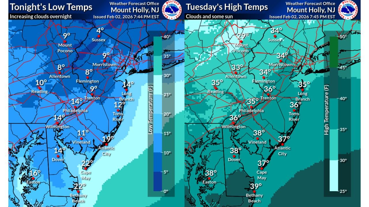
UNITED STATES — Several parts of the Mid-Atlantic managed to climb just above the freezing mark Monday afternoon, but the brief moderation is giving way to another sharply cold night, followed by a cloudier but milder Tuesday across the region. New temperature maps from the Mount Holly forecast office show a stark overnight chill setting up from eastern Pennsylvania through New Jersey and Delaware before daytime highs rebound closer to — and in many spots above — freezing on Tuesday.
Bitter Overnight Lows Settle In Late Monday
As clouds gradually increase overnight, temperatures are expected to drop well below freezing across much of the region, especially inland and north of the I-95 corridor.
In eastern Pennsylvania, overnight lows are forecast to fall into the single digits in several locations. Reading is expected to bottom out near 10°F, while Allentown dips to around 8°F. The coldest air settles farther north and west, with Mount Pocono plunging to near 9°F and Sussex, New Jersey dropping as low as 4°F, marking one of the coldest readings on the map.
Along the I-95 corridor, temperatures remain cold but slightly less extreme. Philadelphia and Wilmington are both forecast to reach lows near 14°F, while Trenton settles around 9°F. Morristown, New Jersey also drops to approximately 9°F, reinforcing how widespread the cold air mass is overnight.
Coastal Areas Avoid the Worst of the Freeze
Closer to the coast, the Atlantic Ocean helps moderate temperatures slightly, though conditions will still be frigid. Atlantic City is forecast to dip to around 19°F, while Cape May and Bethany Beach both hover near 22°F. Long Branch and Toms River remain colder than the immediate shoreline, with lows near 14°F and 12°F, respectively.
Even with cloud cover increasing overnight, the cold air remains entrenched, preventing temperatures from leveling off until closer to sunrise.
Tuesday Brings Clouds and a Modest Warm-Up
By Tuesday afternoon, a noticeable temperature rebound is expected across much of the region, although cloud cover will be more persistent, limiting how much warming occurs. Most inland locations rise back into the lower to mid-30s, while coastal and southern areas approach the upper 30s.
In eastern Pennsylvania, highs are forecast to reach around 33°F in Allentown, 35°F in Reading, and 36°F in Philadelphia. Farther north, Mount Pocono struggles to warm, topping out near 29°F, making it one of the few areas that may stay below freezing all day.
Across New Jersey, Trenton reaches approximately 36°F, Morristown climbs to 34°F, and Long Branch and Toms River both reach the mid-30s. Vineland and Dover warm more efficiently, with highs near 38°F, while Bethany Beach reaches around 39°F, the mildest spot on the map.
What This Means for the Region
The combination of hard overnight freezes followed by daytime thawing may lead to refreezing issues on untreated roads, sidewalks, and bridges, especially in areas that saw melting Monday afternoon. While no precipitation is indicated in the data, lingering moisture could refreeze overnight before improving conditions Tuesday afternoon.
Residents should be prepared for another cold start to the day, with winter coats and cold-weather precautions necessary during the morning commute. The gradual warming Tuesday offers some relief, but temperatures remain near seasonal lows for early February.
As clouds linger and temperatures hover near freezing, winter’s grip remains firm across the Mid-Atlantic.
Stay with Waldronnews.com for continued weather updates, regional forecasts, and developing conditions across Pennsylvania, New Jersey, Delaware, and beyond.