
Delaware and Southern New Jersey Bury Under 15–20 Inches While Maryland and I-95 Corridor See Sharp Drop-Off — Coastal Jackpot Storm Leaves Dramatic Snow Divide
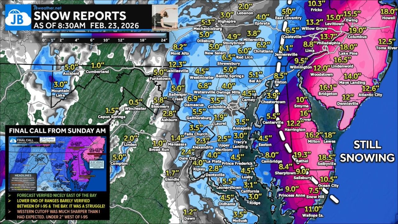
DELAWARE — Final snowfall reports from the February 23, 2026 coastal winter storm reveal a dramatic and highly localized jackpot zone stretching from the Delmarva Peninsula through southern New Jersey, while areas just west of the Chesapeake Bay and along the I-95 corridor saw totals fall off sharply.
The storm, which tracked close to the coast, produced a textbook example of a coastal-focused snowfall event — with heavy bands hugging the Atlantic side of Delaware and New Jersey, and much lighter accumulations farther inland across Maryland and northern Virginia.
Jackpot Zone: Delaware and Southern New Jersey
The highest snowfall totals were reported across coastal Delaware and southern New Jersey, where persistent ocean-enhanced bands set up overnight.
Notable totals include:
Delaware
- Bethel, DE – 19.3 inches
- Lewes, DE – 18 inches
- Milton, DE – 16.2 inches
- Selbyville, DE – 18.5 inches
- Harrington, DE – 12.2 inches
- Smyrna, DE – 10 inches
- Dover, DE – 16 inches
- Ocean City area (near DE coast) – 10.5 inches
- Wallops Island (near VA/DE line) – 11 inches
Southern New Jersey
- Columbus, NJ – 19 inches
- Lake Pine, NJ – 18 inches
- Lindenwold, NJ – 16.5 inches
- Mays Landing, NJ – 14 inches
- Bridgeton, NJ – 16.1 inches
- Woodstown, NJ – 12 inches
- Atlantic City, NJ – 12.6 inches
- Toms River, NJ – 12.5 inches
- Ewing, NJ – 15.5 inches
- Levittown, NJ – 15 inches
Snow was still falling in parts of coastal New Jersey at the time of reporting, suggesting localized totals could climb even higher in some communities.
Sharp Cutoff Across Maryland’s Eastern Shore
Just west of the heaviest bands, totals stepped down quickly across eastern Maryland.
Some representative totals:
- Cambridge, MD – 8 inches
- Easton, MD – 4.5 inches
- Chestertown, MD – 3.9 inches
- Elkton, MD – 8.5 inches
- Annapolis, MD – 3 inches
- Upper Marlboro, MD – 2.5 inches
- Prince Frederick, MD – 4.5 inches
- Leonardtown, MD – 5.5 inches
The gradient was striking — areas near the Delaware line approached double digits, while locations only 20–40 miles west saw totals cut in half.
I-95 Corridor: 3–6 Inches in Many Spots
Along the I-95 corridor through Maryland, snowfall totals generally fell into the 3 to 6 inch range, with some localized higher amounts north of Baltimore.
Examples include:
- Baltimore-area communities – around 4 to 6 inches
- Owings Mills, MD – 4 inches
- Columbia, MD – 3.5 inches
- Laurel, MD – 1.9 inches
- Gaithersburg, MD – 5.5 inches
- Damascus, MD – 6.9 inches
- Watersville, MD – 6.8 inches
Northern Maryland and southern Pennsylvania saw moderate accumulations:
- Shrewsbury, PA – 6.5 inches
- Red Lion, PA – 6 inches
- Dillsburg, PA – 5 inches
- Mechanicsburg, PA – 5.3 inches
West of I-95: Totals Collapse to 1–3 Inches
The western cutoff was even more dramatic.
Across western Maryland and into parts of northern Virginia and West Virginia, snowfall struggled to accumulate significantly:
- Winchester, VA – 0.5 inches
- Broad Run, VA – 1 inch
- Falls Church, VA – 1.4 inches
- Manassas, VA – 1 inch
- Glendie, MD – 1.7 inches
- Dawn, MD – 1.2 inches
- Cumberland, MD – 1 inch
- Mountain Lake, WV – 3 inches
- Accident, MD – 5 inches
In several locations west of I-95, totals remained under 2 inches — confirming that the western edge of the snow shield was much sharper than originally anticipated.
Forecast Verification: Coastal Win, Inland Bust
Forecast discussions noted that:
- The heaviest snow verified nicely east of the Chesapeake Bay.
- Lower-end totals were more common between I-95 and the Bay.
- The western cutoff was significantly sharper than expected.
- Under 2 inches was common west of I-95 in multiple communities.
This pattern underscores how coastal storms can produce dramatic snow gradients, where a shift of just 25–50 miles determines whether a location receives nearly two feet of snow or barely a coating.
A Classic Coastal Setup
This event serves as a textbook example of how Atlantic moisture and banding can lock onto coastal zones, especially across:
- Delaware
- Southern New Jersey
- Eastern portions of Maryland
Meanwhile, interior communities in Maryland, northern Virginia, and West Virginia were left on the lower end of snowfall expectations.
WaldronNews.com will continue tracking winter weather patterns as late-season systems remain possible across the Mid-Atlantic in the coming weeks.