
Denver and Colorado’s Front Range Shiver Through Cold Friday Before a Dramatic Warm-Up — 70s and 80s Return Saturday Through Monday as Active Pattern Looms for Tuesday
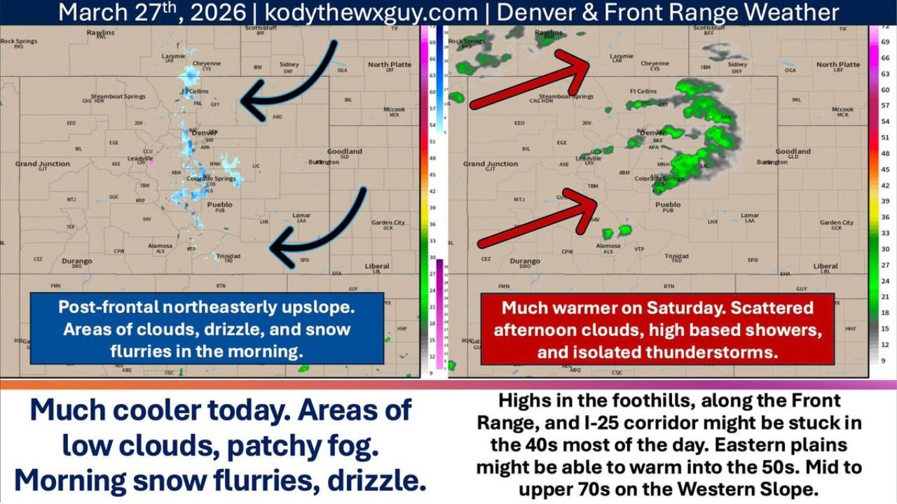
DENVER, COLORADO — Friday is shaping up to be a tale of two Colorados — and honestly, that’s just Colorado being Colorado. A cold, cloudy and blustery Friday has settled across Denver, the Front Range and the I-25 corridor behind the departing cold front, with post-frontal northeasterly upslope flow delivering the classic combination of low clouds, patchy fog, morning snow flurries and drizzle to much of the region. But the cold doesn’t last long — by Saturday, temperatures flip hard, with 70s to low 80s returning to the Front Range and 80s to low 90s possible across the eastern plains of Colorado by Sunday.
Then, starting Tuesday, the pattern gets complicated — and active — all over again.
Colorado Regions in the Forecast Zone
Friday’s cold and Saturday’s dramatic warm-up affect distinct areas of Colorado very differently:
Friday — Cold and Cloudy:
- Denver metro, Front Range and I-25 corridor — highs stuck in the 40s to near 50°F, low clouds, patchy fog, morning flurries and drizzle
- Fort Collins, Colorado Springs, Pueblo — same post-frontal upslope setup, limited sunshine, cloud breaks possible by afternoon
- Eastern Plains of Colorado — slightly warmer, pushing into the 50s as upslope weakens through the day
- Western Slope (Grand Junction corridor) — a completely different story at mid to upper 70s — because Colorado makes zero sense and never will
Tonight into Saturday Morning — Wind Event:
- East of I-25 corridor — low level jet kicks in overnight, southerly winds ramp up with gusts of 30 to 50 mph possible
- Nebraska border and western Kansas — wind gusts extending into Nebrasky and western Kansas overnight
- Secure trampolines, trash cans and any loose outdoor items before Friday night
Saturday through Monday — Warm-Up:
- Denver and Front Range — 70s to low 80s Saturday through Monday
- Eastern Colorado plains — Sunday could bring highs of 80s to low 90s as mid-level moisture creeps in from the southwest
- Afternoon clouds each day with widely scattered high-based showers and isolated thunderstorms — nothing widespread, just enough to keep things interesting
Primary Weather Impacts Friday Through Monday
Here is what Denver, Colorado residents and travelers should expect across the multi-day period:
- Friday morning — patchy fog, snow flurries and drizzle along the Front Range and I-25 corridor — watch for slick spots
- Friday afternoon — upslope flow weakens, fog and flurries back off, cloud breaks possible across Denver metro and Colorado Springs
- Friday highs — 40s to near 50°F along the Front Range, 50s on the Eastern Plains, mid to upper 70s on the Western Slope
- Friday night — southerly winds gusting 30 to 50 mph developing east of I-25 stretching into Nebraska and western Kansas
- Saturday — dramatic warm-up to the 70s to low 80s across Denver and the Front Range, afternoon clouds with isolated thunderstorm chances
- Sunday — similar to Saturday along the Front Range, 80s to low 90s possible on the far eastern Colorado plains
- Monday — continued warmth, afternoon convective storm chances persist
Why the Western Slope Temperature Difference Is So Dramatic
The Western Slope of Colorado — centered around Grand Junction — is forecast to reach the mid to upper 70s on the same Friday that Denver is barely reaching 50°F. This extreme temperature contrast is the result of the post-frontal northeasterly upslope flow, which funnels cold air up the eastern slopes of the Rockies while the Western Slope sits in a completely different air mass entirely — sheltered from the cold easterly flow and benefiting from dry, subsiding air on the lee side of the mountains. It is a uniquely Colorado meteorological quirk that produces head-scratching temperature differences across the state on a near-weekly basis.
Active Pattern Arrives Tuesday — The Great Basin and Rockies Shift
Starting Tuesday, global models and ensemble guidance are lining up on a more active weather pattern across the Great Basin and Rocky Mountain region. The specifics for Denver and Colorado are still a bit fuzzy at this range, but the general pattern signals:
- Cooler temperatures returning to Denver, the Front Range and eastern Colorado
- Better precipitation chances as the active pattern establishes itself
- Busier weather overall as the region transitions from the warm stretch into a more dynamic early-April setup
The pattern shift aligns with the broader national transition already underway — March goes out warm, April comes in active across much of the central United States including Colorado.
What to Watch Next
Key items to monitor for Denver and Colorado heading into the weekend and beyond:
- Friday night wind gusts — particularly east of I-25 through the Burlington and Lamar corridors into Nebraska and western Kansas
- Saturday and Sunday thunderstorm timing along the Front Range — afternoon convective initiation possible each day
- Eastern Plains temperature peaks — whether Sunday hits the low 90s in the Lamar, Burlington and Tribune corridors
- Tuesday pattern shift — when global models and ensembles lock in on timing and precipitation type for Denver and Colorado
- Western Slope temperatures — whether the warm trend continues or the active pattern reaches Grand Junction by next week
Residents across Denver, Fort Collins, Colorado Springs, Pueblo and the broader Front Range should enjoy the weekend warmth — but keep an eye on afternoon storm chances each day and stay alert for the pattern shift arriving by Tuesday.
WaldronNews.com will continue tracking Colorado’s rapidly evolving weather pattern and provide updated forecasts for Denver, the Front Range and eastern Colorado as the Tuesday active pattern comes into better focus.