
Denver, Boulder and Colorado Foothills Preparing for Quick-Hitting Friday Snow as Cold Front Brings Wet Bands and Mountain Totals Up to 12 Inches
COLORADO — A quick-moving late winter storm is expected to bring wet snow across Colorado’s Front Range early Friday, with the heaviest accumulations expected in the foothills and mountain communities west of Denver and Boulder. Forecast projections show light snow for the lower elevations but significantly higher totals in the foothills and higher terrain, where colder air and elevation will allow snow to accumulate more efficiently.
Meteorologists say the system will arrive after a cold front sweeps through Thursday night, bringing gusty winds and rapidly falling temperatures ahead of the snowfall.
Cold Front Arrives Thursday Night Ahead of Snow
The weather pattern will begin shifting late Thursday evening as a cold front moves into the Front Range, bringing gusty winds and dropping temperatures overnight.
By the early morning hours Friday, colder air will allow rain showers to transition into widespread wet snow, especially between 2 a.m. and sunrise across northern Colorado.
As temperatures continue falling toward the freezing mark, snow coverage will expand across the Denver metro area, Boulder County, and nearby foothill communities.
Snow Expected During the Morning and Midday Hours
The most consistent snowfall is expected between early Friday morning and mid-afternoon, with forecasters indicating that snow could become moderate to briefly heavy at times during the morning commute.
Cities likely to see snowfall during this period include:
- Denver
- Boulder
- Longmont
- Broomfield
- Westminster
- Fort Collins
- Aurora
However, the event is expected to be relatively short-lived, with snow gradually tapering off by Friday evening as the system exits the region.
Lower Elevations Likely to See Limited Accumulation
Because of relatively warm ground conditions and daytime temperatures near freezing, snowfall accumulation in the lower elevations may remain limited.
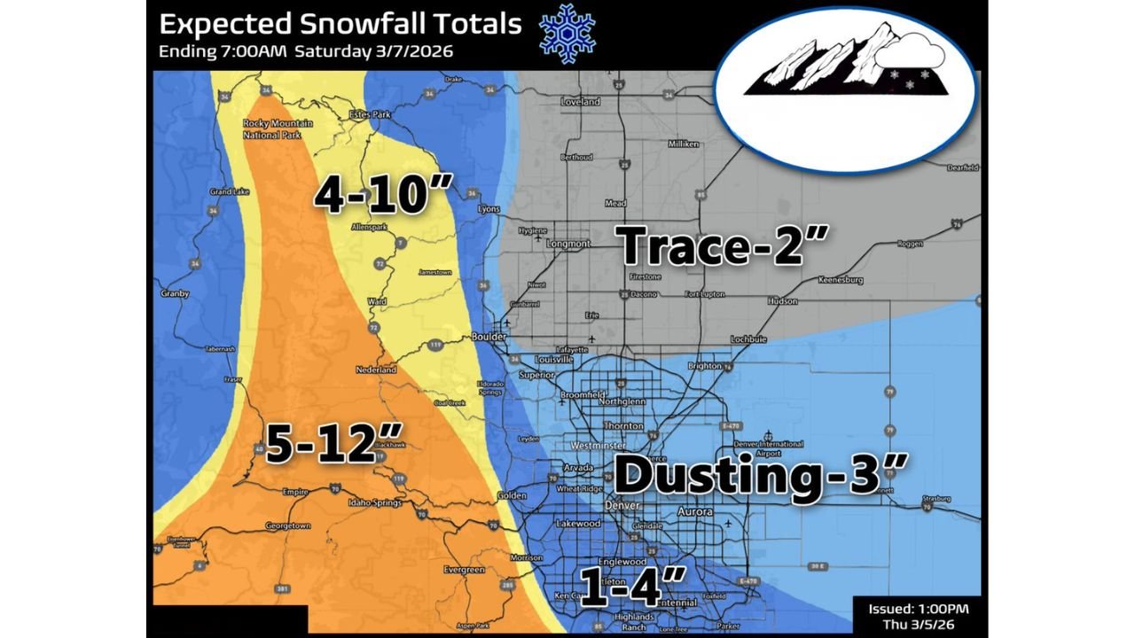
Forecast totals across the northeast plains and northern Front Range communities are expected to range from a trace to around 2 inches.
In the Denver metro area, snowfall totals could vary significantly depending on location, with projections generally showing a dusting to around 3 inches, though some southern metro areas could receive closer to 1 to 4 inches where snowfall rates briefly intensify.
Meteorologists note that melting on roadways will likely occur during parts of the day, reducing overall travel impacts in many areas.
Foothills and Mountain Communities Could See Much Heavier Snow
While lower elevations will see lighter totals, foothill and mountain locations west of Boulder and Denver could receive substantially higher snowfall amounts.
Forecast projections show:
- 4 to 10 inches across the foothills near Estes Park and Nederland
- 5 to 12 inches possible in higher mountain terrain west of Boulder
- Locally higher amounts possible where snowfall bands persist
Areas such as Evergreen, Idaho Springs, and mountain communities along the Front Range foothills may see the most significant accumulation during this event.
Travel Impacts Expected Mainly in Higher Terrain
Despite the snowfall, travel impacts across the Denver metro area may remain relatively limited because of melting conditions and the short duration of the storm.
Roads in the lower elevations are expected to remain mostly wet with slushy conditions possible during heavier bursts of snow.
However, drivers traveling through mountain passes and higher elevation roads may encounter more significant snow-covered conditions and reduced visibility.
Sunshine and Warmer Weather Expected This Weekend
The winter weather will move out quickly Friday evening, with skies expected to clear overnight as temperatures drop sharply into the mid-teens to lower 20s across the Front Range.
By the weekend, conditions will improve dramatically, with sunny skies returning and temperatures warming into the 50s on Saturday and potentially the 60s by Sunday.
The rapid return of mild weather should help melt remaining snow in lower elevations across the Denver metro area.
Stay with WaldronNews for continuing updates on Colorado’s changing weather conditions as this quick-moving Front Range snow event develops.