
Denver Rain Showers After 3PM While Mountain Snow Above 7,000 Feet Targets Winter Park and I-70 Ski Corridors; 60s Return by Sunday and Monday
DENVER, COLORADO — Increasing clouds will thicken across the Front Range today, with rain showers likely developing in Denver after 3 p.m., while colder air over higher terrain turns precipitation to snow above 7,000 feet — creating slick travel conditions in the mountains after dark.
Early afternoon highs in Denver are expected to reach the upper 50s before showers move in. The setup favors rain across the metro area, but the story changes quickly west of the city.
Rain for Denver, Snow for the Mountains
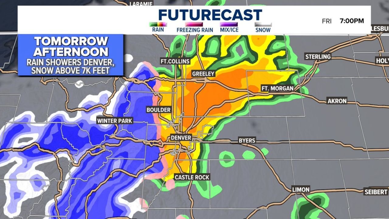
Futurecast guidance shows precipitation expanding from west to east by early evening. Key impacts include:
- Denver: Spotty to scattered rain showers late afternoon into evening
- Boulder: Rain likely, with nearby foothills transitioning to snow
- Castle Rock: Rain showers, possibly mixed briefly in higher elevations
- Fort Collins and Greeley: Showers spreading northward into the evening
- Fort Morgan and Akron: Periods of rain as activity moves east
Meanwhile, snow intensifies across higher elevations west of the metro:
- Winter Park: Steady mountain snow
- I-70 west of Denver: Snow-covered stretches possible after sunset
- Higher passes above 7,000 feet: Slushy to slick road conditions
Travelers heading into the high country late today should be prepared for winter driving, especially after dark as temperatures cool.
Timing: Late Afternoon Through Evening
The most active period appears to be late afternoon through early evening, with precipitation peaking around the 7 p.m. timeframe in the Denver area.
Rain totals in the metro look light to moderate, but elevation will play a major role in impacts. Just a short drive west of downtown Denver, precipitation shifts to snow.
The rain-snow line is projected near the foothills, meaning neighborhoods at higher elevations could briefly see a mix before changing back to rain.
Weekend Outlook: Drier and Warmer
Conditions improve quickly tomorrow with drier air returning. Highs in Denver are again expected in the upper 50s.
By Sunday and Monday, temperatures are forecast to spike into the 60s across the metro area, marking a noticeable warm-up compared to recent days.
Mountain snow from today’s system will taper off, and road conditions should gradually improve by late tomorrow.
What This Means for Residents
- Metro commuters: Expect wet roads late today
- Ski travelers: Plan for snow-packed stretches after sunset
- Weekend plans: Improving conditions and warmer temperatures
While today brings a brief return to unsettled weather, the warm-up heading into Sunday and Monday will likely melt much of the lower-elevation moisture quickly.
WaldronNews.com will continue tracking Colorado’s shifting weather pattern and provide updates if mountain travel impacts increase this evening.