
Early April Storm Pattern Brings Active but Disorganized Weather Across the Plains and Midwest — Forecasters Warn of Split Flow and Low Severe Weather Potential
UNITED STATES — The much-discussed early April storm pattern is taking shape across the Plains, Midwest and Mississippi Valley, but veteran forecasters are urging caution before raising expectations too high. While the pattern is expected to be active and stormy, a dominant split flow and progressive setup across the upper atmosphere is limiting the ingredients needed for truly organized, high-end severe weather. The bottom line: storms are coming, but the classic tornado outbreak setup this is not — at least not yet.
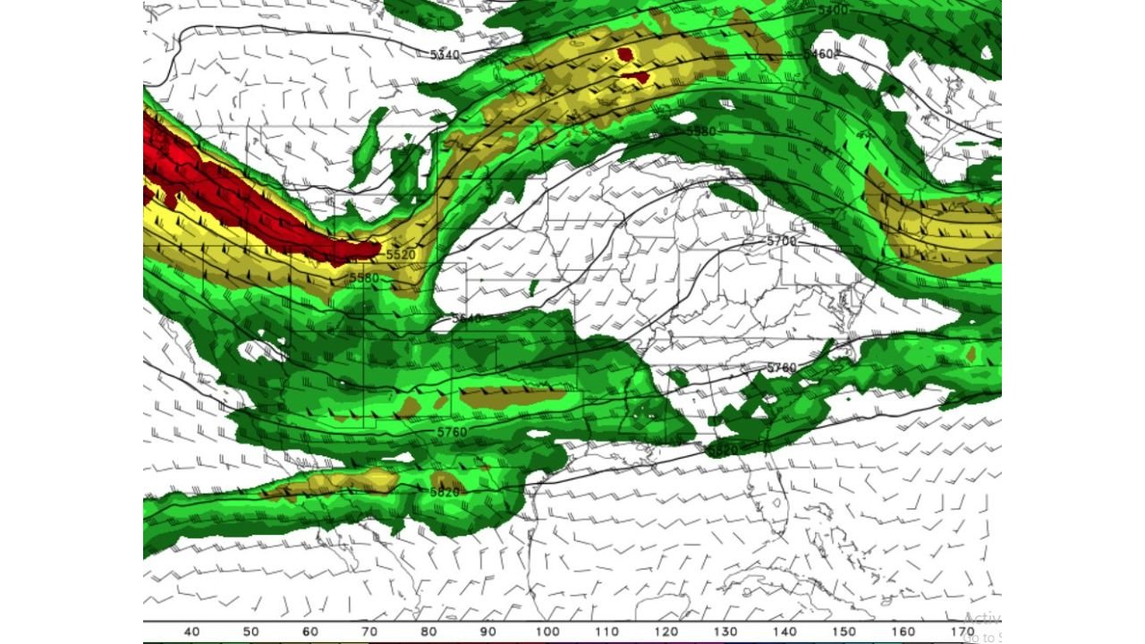
The upper-level jet stream analysis shows a strongly amplified split flow pattern, with the most intense energy displaced well to the north and west across the Pacific and northern Canada, while a separate branch tracks across the southern United States. This configuration is a key reason why meteorologists are tempering expectations despite the stormy overall look.
States and Regions in the Storm Zone
The active weather pattern is focused across a broad corridor of the central and eastern United States:
- Kansas, Oklahoma, Texas — within the southern branch jet stream corridor, active storm potential but disorganized setup
- Missouri, Arkansas, Tennessee — primary zone where split flow energy could trigger scattered storms
- Illinois, Indiana, Kentucky — active and stormy conditions expected but limited severe weather organization
- Ohio, West Virginia, Virginia — eastern fringe where progressive disturbances will bring rain and some thunder
- Mississippi, Alabama — southern edge of the active corridor, storm chances present
- Iowa, Nebraska — northern portions of the active zone under the split flow influence
Primary Threats in the Pattern
Despite the disorganized setup, the early April storm pattern carries real hazards worth monitoring:
- Widespread rain and thunderstorms across Missouri, Arkansas, Tennessee, Illinois and Kentucky
- Scattered severe weather possible — but split flow progressive pattern limits potential for organized supercell development
- Mesoscale boundaries and outflow boundaries could locally enhance severe potential if they develop across Kansas, Oklahoma and Missouri
- Heavy rainfall across portions of the Ohio Valley and Mid-Atlantic remains a concern regardless of severe weather organization
- Multiple disturbances tracking rapidly through the pattern — storms arrive and depart quickly rather than lingering
Why This Pattern Is Less Threatening Than It Looks
The jet stream map tells the real story. A classic, high-end severe weather setup requires a single, strongly phased jet stream delivering deep wind shear and lift across the target area. What the current April pattern shows instead is a split flow — energy divided into a northern branch and a southern branch — with each branch weaker than a unified jet would be.
Forecasters describe this as progressive nonsense — disturbances move through quickly, storms fire but lack the sustained organization needed for long-track tornadoes or significant supercell activity. This is early April, not mid-May, and the atmosphere simply has not reached the level of instability and deep moisture that produces the most dangerous severe weather setups of the season.
Mesoscale boundaries and outflow boundaries — small-scale atmospheric features left behind by earlier storms — could still locally enhance conditions enough for isolated strong or severe storms across Kansas, Oklahoma, Missouri and Tennessee. But the overall picture favors scattered activity rather than a widespread, organized severe weather outbreak.
Multi-Day Pattern: Low-End Temptation With Uncertainty
Meteorologists are characterizing this as a low-end temptation pattern — stormy enough to keep attention but falling short of the dramatic setups that make it onto national news. The split flow is expected to remain the dominant pattern feature through at least the first week of April, meaning multiple rounds of rain and storms are possible across Missouri, Illinois, Indiana, Ohio and Tennessee without any single event standing out as particularly dangerous.
The wild card remains mesoscale features — if outflow boundaries from early storms set up favorably across Kansas, Oklahoma or the Missouri Bootheel, localized severe weather enhancement remains possible even within this overall disorganized pattern.
What to Watch Next
As the early April storm pattern evolves, key items to monitor include:
- Jet stream phasing — whether the split flow consolidates into a more organized, unified pattern
- Mesoscale boundary development across Kansas, Oklahoma and Missouri — the key wild card for severe potential
- Outflow boundary positioning after any early storm clusters across Arkansas and Tennessee
- Rainfall totals across Illinois, Indiana, Ohio and Kentucky where heavy rain risk remains regardless of severe weather potential
- SPC outlook issuance — watch for any day 1 or day 2 severe weather outlooks targeting Missouri, Illinois or Tennessee
- Pattern evolution beyond April 7–8 to see if a more favorable severe weather setup develops
Residents across Kansas, Oklahoma, Missouri, Arkansas, Tennessee, Illinois, Indiana, Kentucky and Ohio should stay weather-aware through the first week of April, keep alerts enabled on mobile devices, and monitor local forecasts closely even as the overall severe weather potential remains below what the stormy overall pattern might suggest.
WaldronNews.com will continue tracking this evolving early April pattern and provide updates as storm timing, rainfall totals and any severe weather potential become clearer in the days ahead.