
East Coast Florida Rain Surge From West Palm Beach To Cape Canaveral Brings 6 To 8 Inches So Residents Should Watch Flooding Risk Before Pattern Ends Thursday
FLORIDA — A significant rainfall event has unfolded along Florida’s east coast over the past several days, with multiple locations reporting over 6 inches of rain and some areas approaching 8 inches, raising concerns about localized flooding before the system exits.
The heaviest rainfall has been concentrated along a narrow coastal corridor stretching from West Palm Beach through Port St. Lucie and up to Cape Canaveral, where persistent bands of rain have repeatedly moved over the same areas.
Heavy Rain Totals Pile Up Along Coastal Corridor
Recent rainfall data shows impressive totals across several cities:
- Port St. Lucie: around 6.6 inches
- Fort Pierce / nearby areas: over 6 inches
- Jensen Beach and Stuart: widespread 6+ inch totals
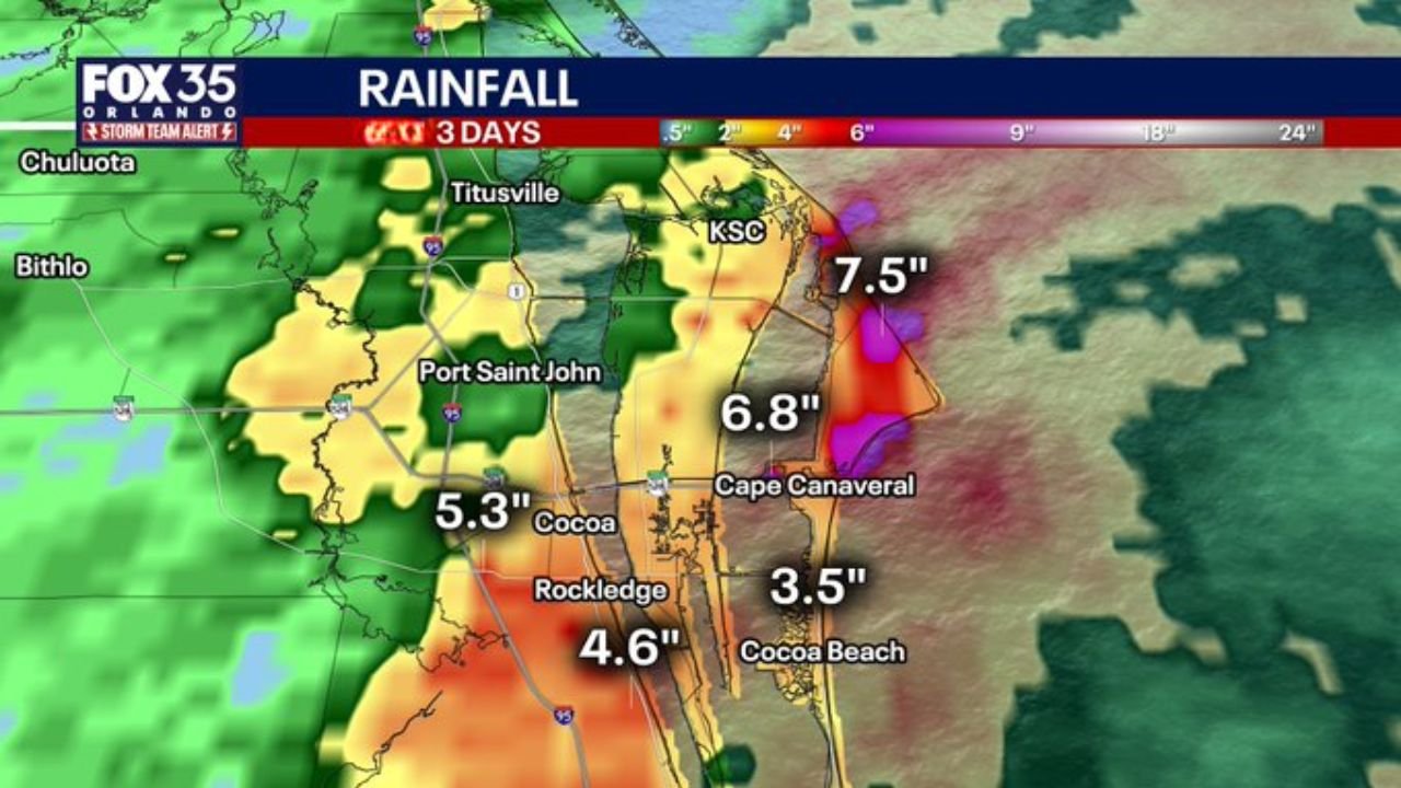
- Cape Canaveral area: around 6.8 inches
- Kennedy Space Center region: nearing 7.5 to 8 inches
- Cocoa, Florida: around 5 inches
- Rockledge: approximately 4.6 inches
- Cocoa Beach: near 3.5 inches
These totals reflect rainfall accumulated since Monday, with the most intense bands focusing just inland and along the immediate coastline.
Rain Bands Continue To Target Same Areas
Radar and rainfall distribution maps show a focused axis of heavy rain running north to south along the east-central Florida coast.
This setup has allowed:
- Repeated rainfall over the same locations
- Gradual buildup of high totals over multiple days
- Increased risk of localized flooding in low-lying areas
Areas slightly inland have seen lighter totals, highlighting how narrow and concentrated the heaviest rain zone has been.
One More Day Of Rain Before Pattern Ends
The current weather pattern is expected to persist into Thursday, bringing:
- Additional rounds of showers and storms
- Continued localized heavy rainfall potential
- Gradual tapering later in the day
After Thursday, conditions are expected to improve as the pattern shifts and rain coverage decreases.
Flooding Concerns Remain Elevated
With several inches of rain already on the ground, even additional moderate rainfall could lead to:
- Ponding on roadways
- Minor flooding in poor drainage areas
- Rising water levels in canals and retention areas
The risk is especially higher in locations that have already received 6 to 8 inches of rain.
Why This Event Stood Out
This rainfall event was driven by:
- Persistent moisture flow along Florida’s east coast
- Slow-moving rain bands
- Repeated storm development over the same region
These factors combined to produce high rainfall totals over a relatively short period, particularly along the coastal strip.
Final Outlook
The east coast of Florida has experienced a notable multi-day rainfall event, with some areas nearing 8 inches of total accumulation.
While the pattern is expected to wind down after Thursday, the immediate concern remains localized flooding in the hardest-hit areas.
Residents from West Palm Beach to Cape Canaveral should remain cautious through the final round of rain before conditions improve.
Stay with WaldronNews.com for continued updates on Florida weather and developing conditions.